

10th yet?�
(Florida's hurricane season peaks the 10th of September and the number of hurricanes��diminishes progressively from then on.)
|
|||||||||||||||||||||||||||||||||||||||||||||||||||||||||||||||
| ������������� Frances On My Mind | |||||||||||||||||||||||||||||||||||||||||||||||||||||||||||||||
| 5:22 p.m., Thursday, 09-02-04: | |||||||||||||||||||||||||||||||||||||||||||||||||||||||||||||||
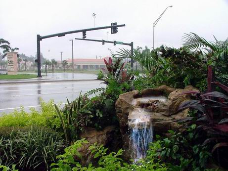
| At the time of this writing, she is still some 300+ miles offshore, slowing down her travel speed to some 10 mph while still packing maximum winds of 145+ mph extending 40 miles from the center.� 500 miles in length and roughly the size of Texas, she sure is taking her time, intent on making her grand entrance in her own fashion.� The worrisome thing is when she makes landfall, her slow speed will take her one day (forecast to be from Saturday to Sunday) to traverse the distance between Central and Northern Florida.��� | |||||||||||||||||||||||||||||||||||||||||||||||||||||||||||||||
| According to weathermen, Frances is almost identical to the September 1928 "Lake Okeechobee Hurricane," also a Category 4, causing the death of 1,836 people (the second deadliest on record, mainly because this was before radar-technology and people didn't know what was coming). | |||||||||||||||||||||||||||||||||||||||||||||||||||||||||||||||
| Weathermen also say that the last time two hurricanes hit Florida within three weeks was in 1950, when one came in from the Gulf and then another came in from the Atlantic Ocean. | |||||||||||||||||||||||||||||||||||||||||||||||||||||||||||||||
| �7:47a.m., Friday,� 09-03-04: | |||||||||||||||||||||||||||||||||||||||||||||||||||||||||||||||
| Frances is beginning to act like a reluctant debutante and is dragging her feet, slowing down to 9 mph, and has become a Category 3 with slower winds of 125mph (although she is forecast to go up to Category 4 again before making landfall).� The bad news is that it will take up to 18 hours for her to traverse Florida and "git the hell outta here."� This also means she will dump up to 24 inches of rain on us, worse if she stalls offshore for a while and then come in. �So now we are under a Flood Watch as well as a Hurricane Watch. | |||||||||||||||||||||||||||||||||||||||||||||||||||||||||||||||
| This surely is going to be an agonizingly slow dance with a wild and tempestuous lady!� Already she has ravaged our usually-sunshine-laden Bahamas Islands neighbors with incessant downpour and blistering winds. | |||||||||||||||||||||||||||||||||||||||||||||||||||||||||||||||
| Forecasters all say she will make landfall very close to our north, give or take a few miles� with the weather beginning to go downhill as early as this afternoon.� Those living or staying (there are thousands of tourists here for the Labor Day weekend) east of US1 (close to the shoreline, for those not familiar with Southern Florida maps) have been asked to evacuate as early as yesterday.� Those who choose to stay are asked the chilling question: "Will you give us the names of your next of kin then?" | |||||||||||||||||||||||||||||||||||||||||||||||||||||||||||||||
|
|||||||||||||||||||||||||||||||||||||||||||||||||||||||||||||||
| Newscasters on all local channels have stayed on the air continuously for the last 24 hours, with eye bags and drowsy stares giving away the heavy toll they have to pay for staying on-the-air longer than they would have wanted.� Now, if only some of them would stop saying "the hurricane is revolving around..." already.� :D | |||||||||||||||||||||||||||||||||||||||||||||||||||||||||||||||
|
|||||||||||||||||||||||||||||||||||||||||||||||||||||||||||||||
| 11:43 p.m., 09-03-04: | |||||||||||||||||||||||||||||||||||||||||||||||||||||||||||||||
| A lady photographer friend in Colorado earlier emailed suggesting I pray that the hurricane veer away and I said I've got some conscience qualms about that because that would be like saying spare us and send the storm over to our friends upstate. So she said then pray that the storm disintegrate offshore and I replied fat chance. But you know what? Frances did disintegrate offshore, lost her eye even, so instead of one big blob, we're just getting "feeder bands " of strong (70mph) winds and rain but at least these only stay for an hour or so and then disappear. | |||||||||||||||||||||||||||||||||||||||||||||||||||||||||||||||
| The main bulk of Frances, though, together with her reforming eye, is forecast to make landfall by tomorrow (Saturday) morning at around 8 a.m. moving at a snail pace 4-5mph. At this slow speed, it will take her one day to traverse the state crosswise, longer if she decides to long lengthwise. :( So we'll know for sure tomorrow if we really what lies ahead.. | |||||||||||||||||||||||||||||||||||||||||||||||||||||||||||||||
|
|||||||||||||||||||||||||||||||||||||||||||||||||||||||||||||||
| 10:05 a.m., Saturday, �09-04-04: | |||||||||||||||||||||||||||||||||||||||||||||||||||||||||||||||
| True to her "diva" form, Frances decided last night to squat directly over Freeport, Bahamas and dumped her wrath on the already-drenched populace.� She had been stationary for some eight hours but has now begun to move, at a slow 5 mph pace, and now forecast to make landfall in West Palm Beach on the Eastern shoreline of �Florida.� ��In the past, hurricanes that stalled have either backtracked or gone in the opposite direction. And the same thing is happening to Frances. Even now, forecasters are saying that she has picked up a more westerly track than her previous north-northwest path.� This means that we in South Florida are bound to get more rainfall and gusty winds than we would have had if Frances had come faster and in a more northerly direction | |||||||||||||||||||||||||||||||||||||||||||||||||||||||||||||||
| 11:25 a.m., �09-04-04: | |||||||||||||||||||||||||||||||||||||||||||||||||||||||||||||||
| The other consequence of Frances' tantrums is that it now seems like she is taking forever to make landfall. A few days back, she had been forecast to hit Florida Thursday afternoon, then Friday morning, then Saturday morning and now she is expected to hit late night Saturday or early Sunday morning.� Geez! �Numerous residents and stranded tourists alike -- especially children -- are beginning to suffer from "cabin fever" (boredom, anxiety, claustrophobia) from being cooped up in evacuation centers (a total of 55,000 people are now huddled in several of these) and dark, shuttered houses, some for the last three days.� To them, this is just like "waiting for Christmas" but in a negative way.� So while some pester emergency authorities to downgrade the Hurricane Warning toHhurricane Watch, others are just itching to let Frances come over and get it over and done with already.�� Added to their frustration is the realization that their hope of salvaging at least one day (Monday, the actual Labor Day holiday) from their aborted holiday weekend has even now been lost. | |||||||||||||||||||||||||||||||||||||||||||||||||||||||||||||||
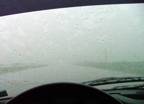
| Because Frances will be moving ever so slowly once she's over Florida, we expect to be pummeled by strong, 70-80 mph gusts, of hurricane-force winds and up to 25 inches (up to 30 inchess in the storm center) of rainfall for the next 18 hours or so (considering that the eye or storm center is preceded by wide storm feeder bands; and long after the center has gone ashore and left Florida altogether, the tail turbulence still has to do so).� Flooding now becomes a concern, too, along with (are you ready for this?) strong thunderstorms, small tornadoes and waterspouts, flying debris and downed power lines. | |||||||||||||||||||||||||||||||||||||||||||||||||||||||||||||||
| The eye of Frances is now estimated to be 70 miles wide (an indication of how disorganized she has become) and her center circulation is still packing 100mph winds even though she's been downgraded to Category 2.� Things are said to get worse before they get better so we have been advised to "expect the worst but hope for the best." | |||||||||||||||||||||||||||||||||||||||||||||||||||||||||||||||
| The staccato raindrops pelting the metal shutters over my window and the banshee moans of gusty winds are now competing with the TV weather update and the keyboard sounds I am making as I type. �I expect the power to go out any minute now.� Already, we've had power hiccups (power outages and surges) so I am saving this every 30 second or so. | |||||||||||||||||||||||||||||||||||||||||||||||||||||||||||||||
| Is Frances one mean lady or what? | More to follow... so keep tuned, folks! | ||||||||||||||||||||||||||||||||||||||||||||||||||||||||||||||
| 3:30 p.m., Sunday, 09-05-04: | |||||||||||||||||||||||||||||||||||||||||||||||||||||||||||||||
|
|||||||||||||||||||||||||||||||||||||||||||||||||||||||||||||||
| We had an impromptu party in the garage last night with relatives, mainly because we had to clear out meat and stuff from freezers and refrigerators and cook these on a propane grill outside the house when power went pffft! early yesterday afternoon.�� We had so many flashlights and tabletop lanterns turned on that one neighbor went out and asked "You guys got electricity?"� :D | |||||||||||||||||||||||||||||||||||||||||||||||||||||||||||||||
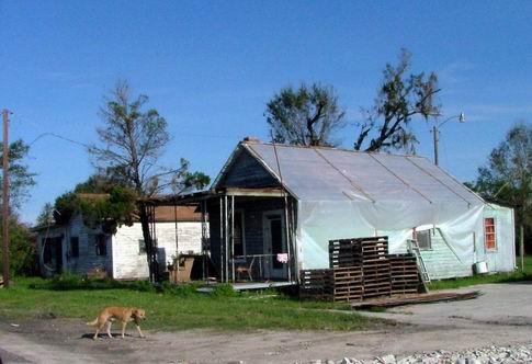
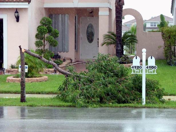
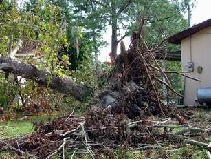
| This morning, we slowly emerged from our metal-shuttered shells in the morning like groggy gophers.� After a few seconds of the customary "look to da sky" and the upward-palms-checking-for-rain rituals, we scanned our surroundings to find that, save for a few bent or broken trees, we are none the worse for wear. �Other folks in the neighboring communities, and even more people up north were not so lucky.� One family's house disintegrated right before their eyes, devoured by winds so powerful as to send tree trunks hurtling as deadly projectiles.� A sinkhole has appeared right on the on-ramp of northbound Interstate 95 in Lake Worth.� A man watched helplessly as his bait boat-cum-residence sank right before his eyes in a waves-buffeted pier. | |||||||||||||||||||||||||||||||||||||||||||||||||||||||||||||||
|
|||||||||||||||||||||||||||||||||||||||||||||||||||||||||||||||
| Epilogue: | |||||||||||||||||||||||||||||||||||||||||||||||||||||||||||||||
| Although fiery Frances had fizzled into a whimpering Category 1 storm as she made landfall last night, she still did howl like a banshee gone berserk in the early morning making sure that weather-weary Floridians didn't dismiss her as "all bark and no bite."� And even as she exits the upper west coast of Florida as a "mere" tropical depression� as I write this, her tail -- moving at 50 mph -- executes a final west-to-east whiplash that reaches as far as Florida's southernmost Key West, dumping torrents into an already-waterlogged state. | |||||||||||||||||||||||||||||||||||||||||||||||||||||||||||||||
|
|||||||||||||||||||||||||||||||||||||||||||||||||||||||||||||||
| But as we say our prayers of Thanksgiving for being twice-blessed, spared from hurricanes Charley's and Frances' fury, we hope to be three-time-lucky as we cast a wary and weary glance at fast approaching Ivan, a weather disturbance near Puerto Rico that has been recently upgraded to a Category 3 hurricane and forecast to follow the very same track that Frances had taken. �In 1964, three Category 3 hurricanes hit Florida one after the other.� So unless Providence steps in his way and nudges Ivan up north and into the Atlantic before it hits Florida, this may very well be "d�j� vu all over again." | |||||||||||||||||||||||||||||||||||||||||||||||||||||||||||||||
|
|||||||||||||||||||||||||||||||||||||||||||||||||||||||||||||||
| Isn't it September 10th yet?� |
|||||||||||||||||||||||||||||||||||||||||||||||||||||||||||||||
| Early this year, U.S. weathermen predicted that as a result of the driest May in years, Florida will have a very active hurricane season in 2004. And true enough, two major hurricanes -- Charley and Frances -- have already wreaked havoc on the "Sunshine State" and one more, Ivan, is on its way. (Florida's hurricane season peaks the 10th of September and the number of hurricanes��diminishes progressively from then on.) |
|||||||||||||||||||||||||||||||||||||||||||||||||||||||||||||||
| �Back to Cosmic Visions | |||||||||||||||||||||||||||||||||||||||||||||||||||||||||||||||