|
|
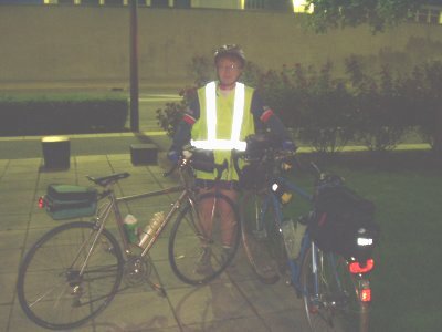
Monday May 20th 2002 The first climb to COL DU GALIBIER |
|
|
|
Monday May 20th 2002 The first climb to COL DU GALIBIER |
|
|
Every two years, BRA is organized in Grenoble. During this ride, you have to complete 250 kilometers in one day passing by "Col du Galibier" and "Col de la Croix de Fer". Last BRA has been organized in July 2001 and you can read the report by following this link. During winter season, "Col du Galibier" is closed. It has been opened again last Friday. So Isabelle and I decided to climb it for the first time of the year. This year, 2002, just before the col an old tunnel has been renewed and inaugurated. Before showing you this new tunnel, I propose you to follow this great ride with your browser... |
|||
|
|||
|
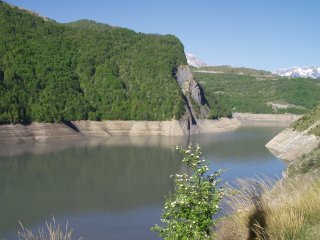
We have lights on our bike and thanks to them, we arrive at 08:00am in "Bourg d'Oisans" . Then the climb becomes steep. After a few tunnels, we arrive at a dam at 1044 meters of altitude. Here is this dam... |
|||
|
|||
|
When you are at this dam, you can see a little village above called "Mizoën"... |
|||
|
|||
|
The main road continues to climb a little to arrive in "La Grave". We are now in "Hautes Alpes" department, at the south of "Isere" and we can have a look on "Meije's glacier"... |
|||
|
|||
|
From this point, there are 10 kilometers left to reach "Col de Lautaret"... |
|||
|
|||
|
This large road is very quiet... |
|||
|
|||
|
After a bend, the road continues to climb towards the sky... |
|||
|
|||
|
|
|||
|
On your right, behind these mountains, the "Massif des Ecrins"... |
|||
|
|
|||
|
|||
|
|
|||
|
Here is now the last kilometer before "Col de Lautaret". On the background, this mountain is called "Pointe du Queyrellin"... |
|||
|
|
|||
|
|||
|
|
|||
|
After 88 kilometers from "Grenoble", we arrived at "Col du Lautaret". This col is easy, on the main road between "Grenoble" and "Briançon"... |
|||
|
|
|||
|
|||
|
|
|||
|
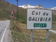
We leave this main road to take a smaller one, the D902 towards "Col du Galibier". We have to complete eight kilometers of easy climb to reach "Col du Galibier"... This climb is scenic... |
|||
|
|
|||
|
|||
|
|
|||
|
It begins to climb. A few bends further, you can see "Col du Lautaret" at the background... |
|||
|
|||
|
Suddendly, the climb is impressive. You climb this col with walls of snow on your left... |
|||
|
|||
|
The more we ride, the more we are close to the Col. The arrow shows you the Col. The new tunnel is just below... |
|||
|
|||
|
Later, we arrive at "Henri Desgranges" memorial. Henri Desgranges is the creator of the "Tour de France". This was the place of the first BRA control step in July 2001. There was less snow at that time... |
|||
|
|||
|
Besides this memorial is a chalet where you can buy food or souvenirs. The new tunnel is just here and if you want to go to "Col du Galibier", you have to climb 100 meters of altitude... |
|||
|
|||
|
Here is the entrance of the new tunnel ... |
|||
|
|||
|
This tunnel is narrow with no lights. It is forbidden to bikes except perhaps if you have lights and if there are no cars... |
|||
|
|||
|
We continue to climb to the col... |
|||
|
|||
|
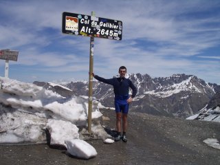
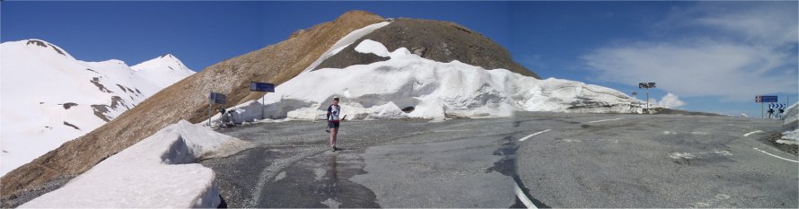
Here is "Col du Galibier". We are 96 kilometers far from "Grenoble" at 2645 meters of altitude... |
|||
|
|||
|
I am pleased to show you panoramic views taken from the col... |
|||
| Arriving from the south side, here is the Col... | |||
|
|
|||
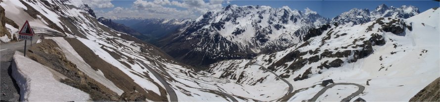
| A panoramic view on the south side, towards Col du Lautaret... | |||
|
|
|||
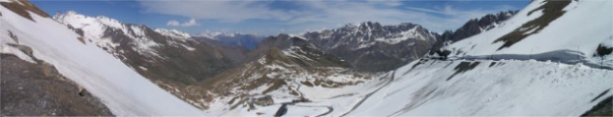
| A panoramic view on the north side, towards Valloire... | |||
|
|
|||
|
Before leaving you, I offer to you some pics of the descent towards tunnel entry, on the other side... |
|||
|
|||
|
What an impressive road with walls of snow.... |
|||
|
|||
|
Later in the descent, the road is closed due to an avalanche. You have to carry the bike if you want to continue the descent... |
|||
|
|||
|
Here is the last bend before the tunnel entry... |
|||
|
|||
|
|
|||
|
Are you ready to climb Col du Galibier ? |
|
|
Page ridden and written by Jean-Philippe BATTU May2002 |
|