| 3/27/01 - Hiked from Amicalola visitor center to Stover Creek Shelter (11.3 miles). Did not plan to hike approach trail but very glad we did. This already puts us one day off schedule. Made fire with 4 others at shelter. Will get into the 20� F tonight. |
| 3/28/01 - Stover Creek Shelter to Justus Creek Campsite. Campsite is a little more crowded today - caught up with some hikers ahead of us! Hiked 11.1 miles today - will hike less tomorrow since we had some pain today. :) Took side trail to Long Creek Falls - gorgeous! Another nice day but drizzling now (after dark - 8:00?) |
| 3/29/01 - Justus Creek Camp to Woody Gap Camp - 6.4 miles. Hiked in
rain all day - made camp early to get out of rain. It started last night @ bedtime.
Trail was OK today - Straight up & down mountains (no switchbacks).
Switch Back - |
| 3/30/01 - Hiked Woody Gap to Neels Gap - 10.7 miles over Blood Mt. Highest pt. on AT in GA. Morning sunny, clouds & fog in afternoon. Shuttle from Neels Gap to town to stay in cabin & dry out from rain, we are staying in cabin w/ another thru-hiker, Debbie from AZ. |
| 3/31/01 - Goose Creek Cabin - Neels Gap to White Oak Stamp Gap (unmarked campsite) - 7.3 miles, AT miles today. Hiked 11:00 am to 4:15. Armie bought new boots today "My feet feel soooo much better!" |
| 4/1/01 - Blue Mountain Shelter - 10.5 AT miles. Broke camp just in time today, it started to sleet as soon as we got on the trail. Today was very windy & cold. Sleet stopped. Now sunny & cold. Still windy. Spending night in the shelter with 5 others & 1 dog. |
| 4/2/01 - Blue Ridge Swag Campsite - 11.1 AT miles. Nice hiking today. Beautiful views from Tray Mt. Our bodies are adjusting to hiking - not many aches & pains. Tomorrow we head into town to resupply & EAT!! Watched sunrise from atop Blue Mt. - was cold, it snowed a little the night before. |
| 4/3/01 - The Blueberry Patch Hostel - 7.2 miles. We made it through our 1st thunderstorm last night. Woke up to rain & packed up as quick as possible. We are now at a hikers hostel. Enjoyed a shower & are staying in a bunkroom w/ 5 other thru-hikers. Looking forward to dinner in town tonight. |
| 4/4/01 - Left Blueberry Patch Hostel 9am - What a blueberry pancake breakfast!! I want to go back!! Lots of fog in the morning, but it cleared up & turned into a great day for hiking!! Crossed into NC today, yeah!! The climb out of Bly Gap (were state line exist) was very very steep. I will have Irene write a letter to the trail people, we both think that should fix it. We made it to muskrat creek shelter, 11 miles and Irene is saying this letter is to long so I must stop now! Armie |
| 4/5/01 - Carter Gap Campsite - Foggy & drizzle again today. Climbed our highest mountain yet - a 5,000 footer called standing Indian. April showers make wet hikers. Tent, backpacks, etc are wet/damp. We went 12.5 miles today - our longest distance yet. It wasn't too bad since the grade of the trail was less steep. |
| 4/6/01 - Mystery?? Campsite - Foggy & drizzle started the day - but the sun is peeking through this evening. Climbed Albert Mt. today - supposed to be good views but we were in a cloud. Passed our 100 mile mark today! Picked a campsite not near shelter to get away from shelters/crowds/weekend hikers/boy scouts/etc.) |
| 4/7/01 - Wine Spring Campsite - Back with a group at this campsite - nice to meet up with them again. Today was much nicer - clear views from Siler Bald. Got warm today, too. Hiked 13.5 miles. |
| 4/8/01 - Wesser Bald Campsite/Shelter - Beautiful hiking again today! Went up the lookout tower on Wesser Bald & we could see Lake Fontana & the Smoky's! We will be there by the end of the week. |
| 4/8/01 - Nantahala Outdoor Center - Hiked 5.7 miles to this outdoor
center along the trail. Spending 2 nights here to eat & rest our legs/bodies.
Tomorrow will be our 1st 0 day & we will hang out here & get stuff done
(laundry, calls, letters, etc.). There is a river here & lots of kayakers/etc
going by. TRAIL NAMES, THEY HAVE TRAIL NAMES - Irene aka "Honey", Armie aka "Moon" together they are the "Honeymooners" They have also been referred to as "The Kramden's" They even have a logo: |
| 4/17/01 RANGER RESCUE - I received a call today from Armie. He said they were proceeding toward Newfound Gap. The temperature was 20 degrees (without the wind-chill), the wind was blowing fierce, and there was 5 inches of snow. They were to meet up with another couple hiking, who had friends picking them up at the Gap, to take all of them to Gatlinburg for the evening. Irene and Armie made it to Newfound Gap an hour early. All they saw at the Gap was a park service truck. The driver told them that the roads were closed to the Gap. Instead of camping the night in a bathroom (seriously), the driver of the park truck contacted the Ranger who took them to Gatlinburg for the evening. THEY ARE BOTH OK. Ok, so it wasn't a dramatic rescue, but they did have to get off the trail because of the weather. One other thing, Irene has poison sumac which I'm told is healing nicely. |
| 4/10/01 - Nantahala Outdoor Center - Took a rest day today. This place is very cool. They have whitewater rafting, kayaking, mountain biking, etc... We just choose to hand out & eat!! |
| 4/11/01 - Locust Cover Gap Campsite - The hike out of NOC was LONG. It was 7 miles uphill to Cheoah Bald. It was nice up there with good views. We left early this morning to beat the heat. It was sunny & hot but not as it has been (90�). |
| 4/12/01 - Cable Gap Shelter/Campsite - Great day to hike - nice breeze & cooler temps. It sprinkled a couple of times this evening & may rain overnight. Seeing a lot of wildflowers starting to bloom in the mountains. |
| 4/13/01 - The Hike Inn - Fontana Dam - 6.9 miles. Friday the 13th Started out unlucky buy our luck has turned! It started out pouring rain & we packed up as quick as possible. We then hiked to the Dam & got a shuttle here. We are getting our food, packs, etc ready for the Smokies. The sun is out & everything is drying. Can't wait to begin the Smokys tomorrow! |
| 4/14/01 - Russell Field Shelter - 13.5 miles Our first day in the Smoky Mountains was beautiful! Great views from the firetower on Shuck Stack Mt. We are staying in the shelter because storms are forecast & our packs are heavy enough (w/ Easter Candy) without having a wet tent fly & packs! |
| 4/15/01 - Derrick Knob Shelter - 9.2 miles. Thunderstorms moved in last night & this morning. The trail was SUPER muddy & the going was slow. Took shelter for 1 1/2 hours this morning during the worst of it. Hopefully tomorrow will be nicer. The AT is on the border of NC/Tenn so we have entered our 3rd state! (Tennessee) |
| 4/16/01 - Mt. Collins Shelter. 13.5 miles. Today was great! It started out cold & foggy, then very windy & we were getting pelted with ice falling from the trees. Then the sun came out! We had terrific views from Clingmans Dome, the highest point on the AT @ 6643ft. It may snow tonight & we are all in our sleeping bags in the shelter trying to stay warm. |
| 4/17/01 - Gatlinburg - 5.5 miles. We ar in Gatlinburg, about 12 miles from Newfound Gap. We woke to flurrys. As we started hiking it turned into a full snowstorm. We were going to get a ride at the Gap but the road was closed! Rangers gave 5 of us a ride down & we are sitting out the storm in town. Hopefully we will get back on the trial tomorrow. |
| 4/18/01 - Gatlinburg - 0 miles. Stuck here due to bad weather. Still very cold in Smokys! Road to trail was closed this morning so we will leave tomorrow for sure! This town is like being in Wildwood w/o the boardwalk - good for a couple of hours but we are ready to be hiking again. |
| 4/19/01 - Pecks Corner Shelter - 10.4 miles. Had great hiking weather. The snowstorms are gone & the sky is clear. The trail was a bit icy, but the views were fantastic. It feels great to get out of Gatlinburg & back on the trail. Tonight we are tenting near the shelter & the shelter is packed w/ thru-hikers who have finally escaped town. |
| 4/20/01 - Cosby Knob Shelter - 12.9 miles. Tonight is our last night in the Smokys. We are tenting near the shelter. Today was nice hiking again. We got real lucky going through the Smokys - some hikers have rain every day. This is the worst shelter yet - Mt. Goat called it the "Ghetto Gap Shelter"! Glad we are in the tent. |
| 4/21/01 - Painter Branch Campsite - 12.7 miles. We made great time getting out of the Smokys - 8 miles in 4 hrs! We had a long lunch break at 'Mountain Mamas', a local cheeseburger/grill/convienence store. We continued on to this campsite in 80� & sunny weather. What a change from earlier in the week. |
| 4/22/01 - Max Patch Mountain - 11.8 miles. Another HOT day again today. This campsite makes up for it! We are camping on a bald, which is basically a huge, grassy, mountaintop. We have views in every direction. We are a little below the summit & will be going up there to watch the sunset. |
| 4/23/01 - Deer Park Mt. Campsite - 16.1 miles! Got an early start today so we were able to go pretty far. Another hot day, but at least the terrain was not as steep as yesterday. We have a short day tomorrow as we hike int Hot Springs, finally we can shower! You can not imagine how bad we smell after 6 days on the trail, especially in this heat! Argh.... We just found 2 gravesites near our campsite. Hopefully we make it through the night..... |
| 4/24/01 - Hot Springs - 3.2 miles. We are staying in Hot Springs tonight. We found an awesome place to stay called Elmers. They are all vegetarian & serve breakfast & dinner! Woohoo!! This is an old victorian house & we have a room upstairs. They have a huge porch & LOTS of books! I am in heaven... There is also a pub in town. We may never leave :) |
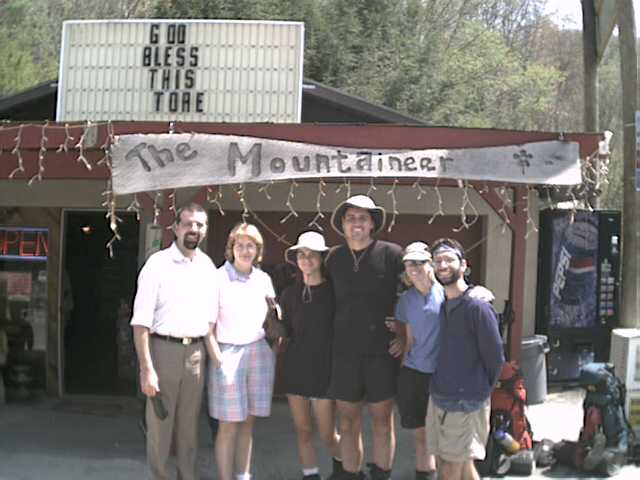
| FIRST VISIT - After a brief 3 mile hike off the trail, Honey, Moon, Mt.
Goat, and Hip Bone stopped by Bret and Tina Wooton's tore, I mean Store. Bret is the
Webmasters brother-in-law (Barbs Brother)
Click on the image for a larger pic. From left to right: Bret, Tina, Honey, Moon, Mt. Goat, and Hip Bone |
A couple of comments from Armie when the webmaster spoke with him:
"The tent is much heavier when it's wet"
"You have too many clothes on going up the mountain and it's hotter"
"You don't have enough clothes going down the mountain and it's colder"
A visitor at the visitor center to Irene & Armie:
"You walked 200 miles?, that's what they have planes for"
Note: The webmaster is not responsible for grammar or misspellings, the notes are as taken from the trail.