Deseret Peak
Tooele County
16 September 2000
Hikers
Jared Tolman, Tom Tolman
The Story
Our hike to Deseret Peak began over six years ago. We did take a break as I served a mission and graduated from college, but Dad and I were introduced to the mountain in 1994, and we finally realized the goal of standing on top of it in 2000.
I had a month between the time I finished my freshman year at BYU and the time I entered the MTC. I wanted to fill this month with as much Utah scenery and family bonding time as possible. So one weekend, Dad and I strapped on the backpacks and headed for the hills near Deseret Peak. We ran into a lot of snow, and as it turns out, we weren't as close to the peak as we thought. It was sure a fun, memorable trip though. I remember setting up our tent that evening on probably the only flat, dry place around; then the next morning, opening up our tent door to look out over the Tooele valley as we played our now-famous UNO game.
Let me tell you about this UNO game. We made up our own rules, which evolved to allow addition, subtraction, multiplication, and division. Say I put down a "5." With all our new rules in effect, Dad could put down a bunch of cards in combination, like a "9," a "3," a "4," an "8," and a "1" on his turn. This works because 9 divided by 3 times 4 minus 8 plus 1 equals 5, the number on the card I had played. I would then have to find a combination of cards to equal 1, the number on the last card Dad played.
Now fast forward to Y2K. Once again we found ourselves in the Stansbury Mountains–this time with a little bit better idea of how to get to the peak and with a lot less snow, but without UNO cards. The trail didn't seem familiar at all at first. A lot can change over a little bit of time, including the way you picture a certain place you've been before.
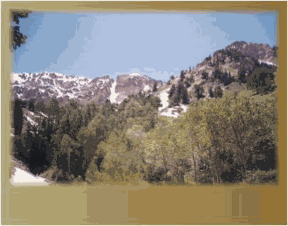
This time, we took the left fork just across the river less than a mile into the hike. The full loop eventually brought us back to this spot. The trail on the first part of this hike is lined with aspens and pines. This woodsy area seems a bit out of place amidst the Tooele County desert landscape; it's beautiful.
Things open up after a while, as the trail leads up a peaceful meadow that turned out to be steeper than it looked. Of course, my being miserably out of shape, and thus out of breath, didn't do much to ease the difficulty any. One incentive to keep a' movin' along was introduced suddenly by a subtly ominous noise, something like an "arrrrrrrrrrrrrrrgghhh," coming from somewhere in the woods not far from where we were taking our first rest stop. That stop soon became a go, as visions of bears or mountain lions–or whatever creature might be capable of making that angry noise–danced in our heads. Perhaps the sound was the growl of an animal not accustomed to visitors on his lonely mountain. Perhaps it was a tired old tree squeaking in the wind. It wasn't a loud sound, but it was enough to convince us to be on our way and to keep an eye out for trouble.
Trouble was kept at bay as we meandered up the meadow to a ridge, where we were met with hang-on-to-your-hat-or-anything-else-you-don't-want-to-part-with chilly wind, which was being funneled through this mountain gap. It was just that one spot that was crazy windy; as we went on our way, winds weren't much of a factor at all. The ridge led us to Deseret Peak, after passing by one peak that faked us into thinking it was the real deal.
We made it to the top, where we sat and ate lunch in a Flintstones-style-hot-tub-looking wind shelter made of large stacked rocks. The view was incredible of the Great Salt Lake and Bonneville Salt Flats on one side, the Wasatch Mountains peaking over the Oquirrhs on another, and wide open valleys all around.
We completed the loop, traveling down what the sign called "Pockets Fork." This is where we hooked into the trail we had traveled last time. Things finally started looking more familiar as past and present came together for the last couple miles of the trail. We now had a better idea of where we had been before in relation to where we were now. However, as the mountain we had just climbed came again into view, we looked up to see where we had been this time, and we never did pinpoint where the actual peak was. Things looked a lot different from below; I guess they always do.
We had to settle for shakes at a Midvale McDonalds because the two Grantsville shake shops were out of business or just plum closed for some reason. Our taste buds had waited over six years for a return trip to Robin's Drive-In. Alas, it appears this classic eating establishment has gone the way of Salem's once-thriving, now-abandoned Burger Barn.
Well, we made it home safe and sound, but there was little rest for the weary; there were demons to destroy. I cleaned up, then went with friends Ryan Morrison and Brian Pugh to the Festival of India in Spanish Fork. In the field between the llama pen and the nearly completed Krishna Temple, the ten-headed demon Ravana went up in flames, while we threw stones in his general direction.