AYP
EDOA
SI
2002
Competence Test
Log
Book
by
Leung Shun Ting, Group A
前言
這次是SI的Competence
test,顧名思義是一個「評核」。
旅程之前,自己都有估計這將會是一次較為辛苦的旅程。
是一次挑戰之餘,也正是一次回顧SI
Part 1的好機會!
簡介
性質:
遠足
日期:
28/09/2002 – 29/09/2000
地區:元朗,大欖
集合地點:
Kowloon Tong Kent Garden
(集合時間):
8:30 am
營地:
Po Leung Kuk Tai Tong Holiday Camp (座標
JK
957 847 )
地圖編號:
HM20C no.6
個人資料
|
Name
|
Nickname
|
Mobile
no.
|
E-mail
address
|
|
Leung
Shun Ting 梁舜婷
|
Jackie
|
93223431
|
[email protected]
|
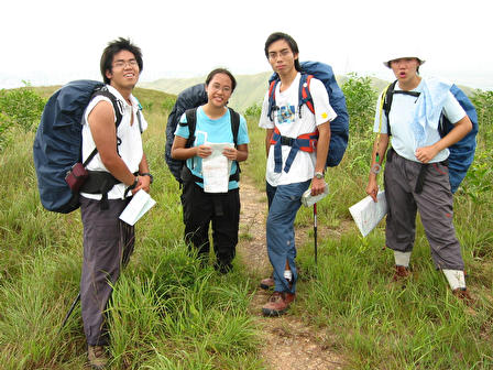
組員資料
Day
1 28/09/2002
Group A
|
Name
|
Nickname
|
Mobile
no.
|
E-mail
address
|
組員觀感
|
|
Chong
Wai Lung
莊偉龍
|
Johnlone
|
92803057
|
[email protected]
|
他是一個教中文的老師,常把一些上課時的趣事告訴我們。頗為健談。
|
|
Lo
Lai Lai, Natalie
勞麗麗
|
麗麗
|
98749664
|
[email protected]
|
她是我的中學同學,曾一起考Silver
Exped。和她很有默契。
|
|
Tsang
Chung Wing, Tommy
曾鍾鑅
|
曾鍾
|
98661097
|
[email protected]
|
一個住元朗的好笑人。
笑聲響亮。
|
|
Tsui
Tik On
徐迪安
|
Andy
|
82010091
|
[email protected]
|
參加RP時認識的朋友。
臉上常有笑容。
|
Day
2 29/09/2002
Team 4
|
Name
|
Nickname
|
Mobile
no.
|
E-mail
address
|
組員觀感
|
|
Wong
Ka Cheong
黃家昌
|
阿昌
|
94173518
|
[email protected]
|
他和我一起參加Gold
Exped.,但那時的認識不深。熱愛行山,體能不錯。
|
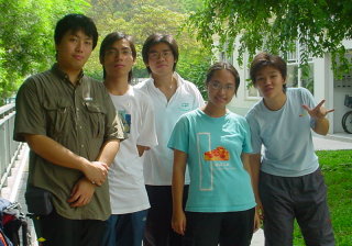
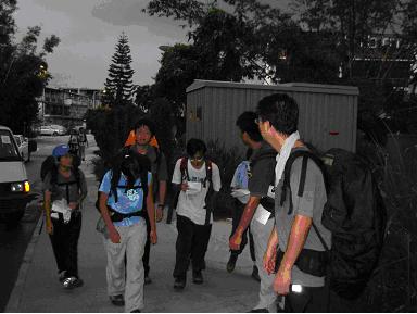
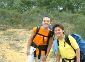
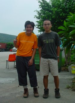
 <--(From
the Left)
<--(From
the Left)
Johnlone, Andy, 曾鍾,
麗麗
and Jackie
Jackie
and 阿昌-->
導師資料
<--SI
Course總導師:文志雄
觀感:文Sir常常有一些今人意想不到的獎品,是一個很
considerate,很有經驗的導師。
Group
A 導師:CHAN
Ying Shu-->
觀感:陳Sir是一位非常有經驗的導師,聽說他是instructor001。陳Sir的樣子帶點童真,有幽默感!
|
裝備
|
數量
|
|
背囊
|
1
|
|
指南針
|
1
|
|
哨子
|
1
|
|
電筒
|
2
|
|
後備電池
|
1
AAA
|
|
後備燈泡
|
1
|
|
水壼
|
1L
*1 500ml *2
|
|
個人食具
|
1
|
|
雨衣
|
1
|
|
風衣
|
1
|
|
替換衣物
|
2
|
|
梳洗用具
|
P
|
|
紙筆
|
1
|
|
零用紙
|
2
|
|
身份證
|
1
|
|
二
人
營
幕
|
營柱
|
3
|
|
營身
|
1
|
|
天幕
|
1
|
|
地蓆
|
1
|
|
酒精爐
|
1
|
|
酒精
|
300ml
|
|
炊具
|
1
set
|
|
地圖
|
no.6×1
|
|
後備食水
|
500
ml
|
|
數碼相機
|
1
|
|
打火機
|
2
|
|
個人藥囊
|
1
|
|
萬用刀
|
1
|
藥囊裝備
|
用品名稱
|
數量
|
|
1”х10yds
薄紗布
|
1
|
|
纖維關節繃帶
|
1
|
|
三角巾
|
1
|
|
葯用膠紙
|
1
|
|
高山求救書
|
2
|
實際行程表
Day 1 28/09/2002
|
CP
|
GR
|
Landmarks
|
Distance(km)
|
Height(m)
|
Actual Time
|
Remarks
|
|
actual
|
total
|
up
|
down
|
Departure
|
Arrival
|
Time Taken
|
|
Start
|
JK 957 847
|
凹頭宿舍
|
1.8
|
1.8
|
220
|
40
|
1047
|
1219
|
1:32'
|
|
|
1
|
966 835
|
山頂220m
|
1.5
|
3.3
|
160
|
100
|
1219
|
1417
|
1:58'
|
休息15min
|
|
2
|
968 824
|
山頂250m
|
2
|
5.3
|
220
|
200
|
1417
|
1600
|
1:43'
|
休息23min
午餐40min
|
|
3
|
959 810
|
高程點
267m
|
3.9
|
9.2
|
200
|
40
|
1600
|
1751
|
1:51'
|
休息10min
|
|
4
|
940 825
|
車路
|
1.5
|
10.7
|
40
|
0
|
1751
|
1822
|
0:31'
|
休息20min
|
|
Camp
Site
|
942 813
|
大棠渡假營
|
|
|
|
|
|
|
|
|
Day 2 29/09/2002
|
CP
|
GR
|
Landmarks
|
Distance(km)
|
Height(m)
|
Actual Time
|
|
actual
|
total
|
up
|
down
|
Departure
|
Arrival
|
Time Taken
|
|
Camp
Site
|
JK 942 813
|
大棠渡假營
|
1.00
|
1.00
|
0
|
40
|
0739
|
0758
|
29’
|
|
1
|
934 819
|
車路
|
2.00
|
3.00
|
140
|
0
|
0758
|
0831
|
33’
|
|
2
|
928 803
|
車路交界
|
0.30
|
3.30
|
20
|
0
|
0831
|
0850
|
19’
|
|
3
|
927 800
|
沖溝
|
3.30
|
6.60
|
80
|
120
|
0850
|
0947
|
57’
|
|
4
|
946 797
|
廟
|
2.80
|
9.40
|
140
|
60
|
0947
|
1106
|
1:19’
|
|
5
|
964 790
|
小徑交界
|
4.18
|
13.58
|
300
|
280
|
1106
|
1233
|
1:27’
|
|
6
|
955 773
|
山頂
|
4.66
|
18.24
|
240
|
480
|
1233
|
1525
|
2:52’
|
|
End Point
|
934 764
|
大欖涌村
|
|
|
|
|
|
|
|
total
distance in 2 days: 28.94km
*
行程圖 à Map
食譜
|
|
第一天
|
第二天
|
|
|
食物名稱
|
份量
|
食物名稱
|
份量
|
|
早
|
|
|
雞蛋
雜豆
米粉
|
1隻
半盒
1包
|
|
午
|
瑞士卷蛋糕
蘋果
|
1個
1個
|
孖寶蛋糕
蘋果
|
1個
1個
|
|
晚
|
雞蛋
比目魚
雜豆
米粉
|
1隻
2片
半盒
1包
|
|
|
|
|
食物名稱
|
份量
|
|
後備食糧
|
罐頭茄汁魚
瑞士卷蛋糕
|
1罐
2個
|
|
緊急食糧
|
巧克力
|
2條
|
交通資料
|
交通工具
|
路線
|
服務時間
|
費用
|
備註
|
|
KMB
|
968
|
銅鑼灣開:06:30
- 00:40
元朗開:05:25
- 23:30
|
20.7
|
銅鑼灣<-->元朗
|
|
KMB
|
64K
|
元朗市開:05:40
- 24:00
大埔墟:05:40
- 00:10
|
6.9
|
元朗市<-->大埔墟(經十八鄉)
|
|
KMB
|
960
|
建生開:05:30
– 23:10
灣仔碼頭開:06:50
– 00:30
|
18.2
|
建生<-->灣仔碼頭(經大欖)
|
|
KMB
|
961
|
山景開:05:30
– 23:10
灣仔會展開:06:50
– 00:30
|
18.2
|
山景<-->灣仔會展(經大欖)
|
求救資料
|
機構名稱
|
座標
|
聯絡電話
|
|
緊急求救熱線
|
Nil
|
999
|
|
醫療輔助隊
|
Nil
|
27622027
/ 27622028
|
|
民安隊
|
Nil
|
28056020
|
|
凹頭政府宿舍
|
JK
957847
|
Nil
|
|
石塘村
|
JK
958842
|
Nil
|
|
南坑排
|
JK
945821
|
Nil
|
|
大棠村
|
JK
936820
|
Nil
|
|
楊家村
|
JK
935814
|
Nil
|
|
郊野公園管理站(大棠)
|
JK
947807
|
|
|
郊野公園管理站(吉慶橋)
|
JK
959796
|
|
|
民安隊圓墩營
|
JK
956770
|
28056028
|
|
大欖懲教處
|
JK
935770
|
2404
4100
|
|
郊野公園管理站(深井聚水塘)
|
JK
966767
|
|
|
大欖郊野公園
|
Nil
|
24774896/24989326
|
天氣報告
|
|
最高氣溫
|
最低氣溫
|
相對濕度
|
雨量
|
天氣慨況
|
|
28/9
|
28.7
|
26
|
80-92%
|
0.8
毫米
|
天晴
|
|
29/9
|
27.2
|
24.7
|
74-97%
|
4.4 毫米
|
天晴
|
 簡報:這兩天的天氣都很適合遠足,有陽光,間中有風。28/9大部份時間的都在山頂或高地,兩旁沒有大樹,太陽頗猛。
29/9大部份的路程都在林間,沿途有不少大樹作遮蔭,加上風勢比昨天強,感覺上比昨天舒服
|
物品
|
金額
|
|
28/9
lunch
|
瑞士卷蛋糕一個
|
$4
|
|
蘋果一個
|
$1.5
|
|
28/9
dinner
|
米粉一個
|
$2.5
|
|
雞蛋一隻
|
$1
|
|
比目魚
|
$18
|
|
29/9
breakfast
|
米粉一個
|
$2.5
|
|
雞蛋一隻
|
$1
|
|
29/9
lunch
|
孖寶蛋糕一個
|
$4
|
|
蘋果一個
|
$1.5
|
|
後備食糧
|
罐頭茄汁魚一罐
|
$10
|
|
瑞士卷蛋糕兩個
|
$8
|
|
緊急食糧
|
巧克力兩條
|
$10
|
|
TOTAL
|
$64
|
營地報告
營地:
Po Leung Kuk Tai Tong Holiday Camp (座標
JK
957 847 )
營位數量:約二十個
衛生環境:良好
煮食環境:良好。有燒烤場在露營地點隔離,有水源。
評語:由於營地在渡假村之中,多方面的環境都十分理想。唯一的缺點是營地設於營舍旁邊,泠氣機的聲響甚大。
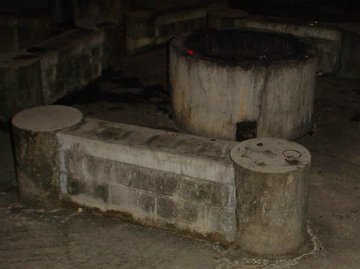
<--煮食地點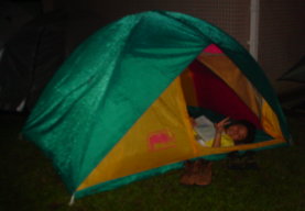
my
tent-->
旅程描述
Day
1 28/09/2002
Start
Point – Check Point 1
Our
start point was Au Tau Government Quarter. After having a short briefing, we
started our journey. We left the main road, and joined on a path leading to a
village. Along the road, there were second-handed cars for sale.
On
the left side of the path, we joined another path going uphill and soon started
accent. Sometimes later, we saw 2 power 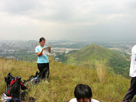 lines
above us, also we could see the hill
with tri. station 220 in front of us and Ho Hok Shan behind us. The weather was
not very hot, sometimes with mild wind, indeed quite good for hiking. As we went
higher, we could see the water treatments works station on the left, the highway
beneath, also the small villages on our right.
lines
above us, also we could see the hill
with tri. station 220 in front of us and Ho Hok Shan behind us. The weather was
not very hot, sometimes with mild wind, indeed quite good for hiking. As we went
higher, we could see the water treatments works station on the left, the highway
beneath, also the small villages on our right.
We
took a rest on the hill-top of tri. station 220. The view there was quite good.
We could see the coming paths. Then we walked under a cable pylon and reached
our check point 1, which was another hill-top.
<--CP1
Check
Point 1 – Check Point 2
After
a short rest at check point 1, we continued our journey. With our next
destination in front of us, we walked downhill. The path along was
well-maintained, though sometimes it’s a bit sandy. We found the signals along
the path are quite new, and guessed it should be a new trail for family walk.
The
path towards the lower part was a little bit messy, but it’s still okay (a bit
difficult for “family trip”). Yet, the path going uphill was quite clear.
The
path in the later part was more gentle. Along the path, we could still see the
features below. There are 2 pavilions along.
CP2 -->
Check
Point 2 – Check Point 3
The
path was just similar to those before. There are sign posts along. Sometimes the
path was a bit grassy, but generally still suitable for a leisure walk or family
trip.
Check
Point 3 – Check Point 4
We
kept hiking downhill gently from check point 3 to check point 4. Not leaving
check point 3 for very long time, we joined a clear path. There are signals
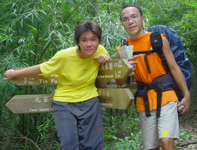
showing the way to Tin Fu Tsai and Nam Hang Pai. Along the path, we saw some
other hikers. We guessed it is quite a popular path for leisure hiking, with
public transport nearby and quite a number of country park facilities.
 Sometimes
later, we entered the area of Nam Hang Pai. We saw a store and some houses, also
some small ponds. Then we were at the junction with one path going into the
village and one going out to the road. We chose the one going towards the road.
We walked along the road towards our campsite.
Sometimes
later, we entered the area of Nam Hang Pai. We saw a store and some houses, also
some small ponds. Then we were at the junction with one path going into the
village and one going out to the road. We chose the one going towards the road.
We walked along the road towards our campsite.
There
are houses along the road and very often boards about the holiday campsites
nearby. Then we saw a path on our left leading to Nam Hang Pai, the junction was
our check point 4.
<--CP 4
Check
Point 4 – Campsite
We
walked up to our campsite, Po Leung Kuk Tai Tong Holiday Camp, along a road
without very busy traffic. Very often, there are signals showing the way to our
campsite and 荔枝山莊.
After passing the way to荔枝山莊for
some time, we arrived at our campsite.
Day
2 29/09/2002
 Campsite – Check Point 1
Cheong
and I together formed team 4, we were the fourth to leave the campsite. We
walked down the road we walked up last night and arrived at a road junction,
then joined the road on the left. There were quite a number of village houses
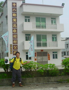
along. Walking towards the end, we saw黃泥墩村村公所, and that’s our check point 1.
<--CP 1
Check
Point 1 – Check Point 2
Then
we continued our journey, we turned left at that road junction and walked along
the small river. Towards the end of the road, we crossed a bridge and reached
the other side of the river. We entered 楊家村and saw a piece of cultivated land and some
ponds. The path was quite sandy, sometimes with a bit mud.
Sometimes later, we started hiking uphill. As we accented, we could see the
villages down the hill and the col of Wong Nai Tun
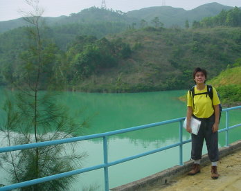 reservoir. We walked up for about 25 minutes, we saw the dam of the
reservoir. The road junction there was our check point 2,
there was a signal showing the way towards So Kwun Tan and bus stop
at Tai Tong.
reservoir. We walked up for about 25 minutes, we saw the dam of the
reservoir. The road junction there was our check point 2,
there was a signal showing the way towards So Kwun Tan and bus stop
at Tai Tong.
CP 2-->
Check
Point 2 – Check Point 3
Our check
point 3 was the沖溝on
a spur up Wong Nai Tun Reservoir. We walked across the
dam and started walking towards the river valley. There was a此路不通signal
at one side of the valley, yet we could see the path clearly, so we walked pass
the signal and went towards the valley. After crossing the river, we walked up
the spur. Man Sir, Chan Sir and Miss Wong were there to take
 our
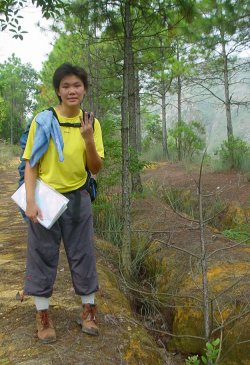
time. Then we went up the spur a bit to find the沖溝.
It’s quite interesting that there are some lowerings on the spur, still like
the miniature of a valley.
our
time. Then we went up the spur a bit to find the沖溝.
It’s quite interesting that there are some lowerings on the spur, still like
the miniature of a valley.
<--CP 3
Check
Point 3 – Check Point 4
After
taking photos next of the沖溝,
we walked down and back to check point 2 in order to join the road . We walked
along the reservoir, slightly going up. The weather was quite good, seemed to be
less shiny than yesterday.
After about 15 minutes, we reached a u-turn point on the road. The view
there was wonderful, we could see the Tai Lam Chung Reservoir down in front of
us. Lots of hikers were taking a rest there. We took a path on our left. There
was a signal showing the direction of Wong Lai Tun Reservoir and So Kwun Tan.
We
started walking uphill after joining the path. According to the map, we should
be going up a small hill and then go down it. However we actually took another
one, which was much more gentle than the one described in the map. We thought
that path was not written on the map, maybe it was opened by hikers to shorten
the path and reduce the ups and downs. The path was well-maintained, with
signals along the path, providing information to hikers.
Sometimes later we saw an abandoned hut, then we joined a road. There were
quite a number of countryside facilities along the
 road, the view on the right was very open, and sometimes we could see Tai Nam
Chung Reservoir. Then we saw Lau Sir and Chan Sir(Chan Kwok Pui). There, on our
left, was an information board about the
Pak
Kung
Temple
, which was our check point 4. There was also a path going towards Tai Nam Chung
Reservoir.
road, the view on the right was very open, and sometimes we could see Tai Nam
Chung Reservoir. Then we saw Lau Sir and Chan Sir(Chan Kwok Pui). There, on our
left, was an information board about the
Pak
Kung
Temple
, which was our check point 4. There was also a path going towards Tai Nam Chung
Reservoir.
CP 4-->
Check
Point 4 - Check Point 5
We
didn’t choose the path, we kept using the road, still going towards Tai Nam
Chung Reservoir. We walked gently downhill. There were lots of countryside
facilities along, including chairs, tables and signals.
After
20 minutes, we reached a bridge. We crossed it, but found that it was not the
one we wanted. We returned and took a rest on the chairs there. Then we found
another bridge, which was the correct one. Unfortunately, the water level was
too high that the
bridge was flooded. We couldn’t cross the bridge, so we changed our mind,
taking the further way to check point 5. We walked towards the “R-point” and
cross the river on a bridge before it.
After
a short while, we saw a path going uphill, we took that to our check point 5.
Sometimes later we reached a path junction, which we could see the original path
we had chosen if the bridge was not covered by water. Then we walked up a little
bit, reaching a path junction with a signal, and that’s our check point 5.
<-- CP 5
Check
Point 5 – Check Point 6
We
chose the 圓墩郊遊徑
after leaving check point 5. We walked along the contour, without going
up or down much. The path was well-maintained, with lots of trees on the two
sides. It is quite suitable for leisure hiking or family trips. Also there were
often signals along the path.
After about 50 minutes, we joined a road. There was a notice board and a
management counter there. The weather was just too good and we took a rest
there. There were 3 roads at the junction, 2 going up and 1 going down. We took
the one going
down, going towards Yuen Tun. We walked for about 30 minutes, passing across 2
road junctions, we reached the Civil Aid Service Yuen Tun Holiday Camp. After a
short rest, we found a path next to its grassland, going towards our check point
6.
CP 6-->
Sometimes later, we joined
an unsurfaced road. We walked across it, joining圓墩郊遊徑again,
what we hope was to go up the small hill-top on our right. We spent sometimes
finding the path leading to the hill-top, but we failed. So we went back to the
unsurfaced road, and walked along it to the hill-top. That was our check point
6, we saw Miss Wong and Lee Sir there to mark our time.
Check Point 6 – End Point
We
spent sometimes discussing, with Miss Wong and Lee Sir, about the path we
couldn’t find. Miss Wong said that path was actually there. Then we left check
point 6, aiming at our end point, 大欖涌村. We had decided
 to
choose the unsurfaced road. The road was very clear and obvious, with some post
of town gas along. Along the road, as we went up and down the hill-tops, the
view was wonderful. We could see the Tsing Ma Bridge and Tsing Yi, also the
coast at Tsing Lung Tau and Tai Nam Chung. The aim was just very clear, we could
see our end point clearly, also the villages, roads and landscape down the hill.
We took a long rest on the highest point of the route,
enjoying the view and wind there.
to
choose the unsurfaced road. The road was very clear and obvious, with some post
of town gas along. Along the road, as we went up and down the hill-tops, the
view was wonderful. We could see the Tsing Ma Bridge and Tsing Yi, also the
coast at Tsing Lung Tau and Tai Nam Chung. The aim was just very clear, we could
see our end point clearly, also the villages, roads and landscape down the hill.
We took a long rest on the highest point of the route,
enjoying the view and wind there.
Then
we went downhill. After crossing a river, we could see the path, as described on
the map, leading to the road above
Tai
Nam
Chung
Village
. Sometimes later, we reached the col with the cultivated land described in the
map. We spent more than half hour searching for the path going down right to
Tai
Nam
Chung
Village
, but we failed. So we decided to change our planned route. We used the
unsurfaced road and joined the road leading to the Correctional Institution
there. Then we walked along the river and reached our end point.
感想
最初聽到這次Competence
Test,一心以為會是一次很harsh的旅程。
剛進了大學,這陣子的睡眠非常不足,前陣子又弄傷了腰,旅程前的一晚又弄傷了背脊;
星期六起床時真的覺得自己不太能夠應付這次「test」,在start
point時確實有想過不參加這次旅程。
過了第一天的旅程,才覺得這次test比想像中輕鬆。
過了第二天,心中更慶幸自己沒有在start
point quit。
一方面很高興自己和大部份同學都能夠pass這個test,
另一方面又覺得,SI的part
one這麼快便完了嗎?
回頭一想,instructor
course到今天已經四個多月了,學過的的確不少,
(其中印象最深刻的是黑夜mountain
rescue)
但是,我們有足夠的能力成為導師了嗎?
也許part
two才是真正的competence
test吧!