![]()
You may have been exposed to radiation released from Hanford if you lived in certain areas of Washington, Oregon or Idaho between 1944 and 1972. This does not mean that radiation harmed the health of everyone living in these areas. It does mean that you may be more at risk for health problems related to radiation than people who did not live in these areas.
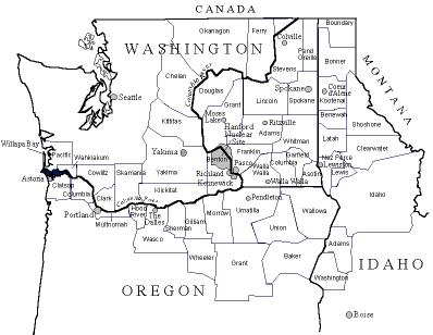
The Hanford Nuclear Reservation in southeastern Washington state released radioactive material into the air, soil and Columbia River. Most of the radioactive material was released from 1944 to 1972. The area exposed extends across Eastern Washington, northeastern Oregon, and much of Idaho, into Montana and Canada, and through the Columbia River downstream from Hanford to Pacific coastal areas. As many as 2 million people were exposed.
With the spread of radioactive material through air and water, no exact borders for the emissions can be determined. This map shows counties that are part of the study for the Hanford Environmental Dose Reconstruction (HEDR) Project. HEDR has estimated the amount or "dose" of radiation that representative individuals who were in this area may have received. (HEDR is a separate project, not affiliated with the Hanford Health Information Network.)
According to HEDR, the main way people were exposed to radiation released to the air was through drinking contaminated milk.The map also includes counties along the Columbia River downstream from Hanford. People were exposed to radioactive material through use of the river or from consuming contaminated food from the river and adjacent Pacific coastal areas.
|
|
![]()