|
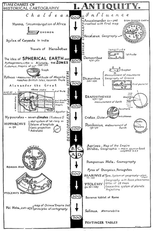
What did cartography and geography mean to the people of antiquity? In modern times it is defined as the art of drawing or compiling maps or charts. Geography, on the other hand, is the science that describes the surface of the Earth and its associated physical, biological, economic, political, and demographic characteristics, especially in terms of large areas and the complex of interrelationships obtained among them. The cartographers and geographers of the classical period, however, were not only interested in terrestial plotting, but also in cosmology. The nature of the universe itself was far more intriguing to these classical peoples, as such only at a basic level does geography, during this period, try to determine the shape of the topographical plane inhabited by humankind. The development of cartography and geography therefore in the ancient world dealt very closely with the nature of the Earth's shape and in doing so determined that the Earth was in fact a sphere. The period of time in which the Greeks were most active in both cartography and geography was between the 6th century BC and the 4th century AD. It may also be added that in the early period of this 800 year span the Greek contribution was speculative and theoretical rather than practical. As with astronomy the Greeks took over the art of map-making from the Mesopatamians and Babylonians. From them they accepted the theory that the earth was a flat circular disk surrounded by a primordial sea. There were two notions of the Earth during this period, the earth known as 'ge' and the inhabited Earth known as the 'oikumene'.
The earliest conception of the Earth entertained by the Greeks was the notion that the Earth was a flat disk covered by an inverted bowl of the sky. In the 6th century BC, however, Ionian philosophers disregarded the bowl shaped sky and divided the heavens into bands. The flat disk theory however still remained. The first person credited with drawing the first map was Anaximander who lived between 610 to 547 BC. Anaximander worked as both a craftsman and philosopher, as indeed most of the earlier geographers during this period did. Anaximander's map was improved 50 years later when Hecataeus, also constructed the first circuit of the Earth, known as the 'periodos ges'. |
|