
In 1993, a system of arterial route numbering in the Sydney metropolitan area was introduced called Metroads. These replaced National Routes and Highways and many State Routes throughout the Sydney region. Metroads are divided up into two types - radial Metroads, which connect the outer suburbs with the city centre of Sydney; and circumferential Metroads, which are major by-pass routes around the Metropolitan area.
There are now nine Metroads in Sydney numbered from 1 to 10 (Metroad 8 has been reserved for future use - my guess is that it will be used for the much needed and long awaited Western Sydney Orbital freeway).
The original Metroad system only had 6 routes - 1, 2, 3, 4, 5 and 7. Metroad 9 was added in 1997; Metroad 10 in 1998 and Metroad 6 in 1999. The Metroad system is in a continual process of refinement; routes are continually expanding and contracting and are often being adjusted.
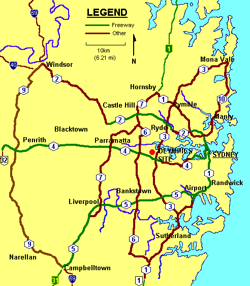
Below is a map of Sydney's Metroad system, showing all Metroads as they stood in January 2003. Freeway portions of the Metroads are in green. The National Routes and Highways and State Routes that radial Metroads meet up with on the metropolitan outskirts are also shown.

Metroad One
EXTREMITIES: Wahroonga to Waterfall
APPROXIMATE LENGTH: 68km (42 miles)
FREEWAY GRADE: 21km (13 miles)
REPLACED: National Route 1
NAMES: Princes Highway, Acacia Road, President Avenue, The Grand Parade, General Holmes Drive, Southern Cross Drive, Eastern Distributor, Cahill Expressway, Sydney Harbour Tunnel, Warringah Freeway, Gore Hill Freeway, Pacific Highway.

Metroad Two
EXTREMITIES: Milsons Point to Windsor
APPROXIMATE LENGTH: 60km (37 miles)
FREEWAY GRADE: 28km (17 miles)
REPLACED: National Route 1, State Route 28 (most), State Route 30 (most), and multiplexed with part of State Route 40
NAMES: Warringah Expressway, Gore Hill Freeway, Longueville Road, Epping Road, Hills Motorway (M2 Motorway), Old Windsor Road, Windsor Road.

Metroad Three
EXTREMITIES: Blakehurst to Mona Vale
APPROXIMATE LENGTH: 53km (33 miles)
FREEWAY GRADE: none
REPLACED: State Route 33 in its entirety
NAMES: King Georges Road, Wiley Avenue, Roberts Road, Centenary Drive, Homebush Bay Drive, Concord Road, Church Street, Devlin Street, Lane Cove Road, Ryde Road, Mona Vale Road.

Metroad Four
EXTREMITIES: Sydney to Lapstone
APPROXIMATE LENGTH: 58km (36 miles)
FREEWAY GRADE: 49km (31 miles)
REPLACED: National Route 32
NAMES: Western Distributor, Anzac Bridge, City West Link Road, Dobroyd Parade, Wattle Street, Parramatta Road, Western Motorway (M4 Motorway).

Metroad Five
EXTREMITIES: Sydney Airport to Campbelltown
APPROXIMATE LENGTH: unknown
FREEWAY GRADE: entire length
REPLACED: National Highway 31 south of Casula
NAMES: South Western Motorway(M5 Motorway).

Metroad Six
EXTREMITIES: Heathcote to Carlingford
APPROXIMATE LENGTH: 40km (25 miles)
FREEWAY GRADE: none
REPLACED: State Route 45 in its entirety, former southern extremity of Metroad 7
NAMES: Heathcote Road, New Illawarra Road, Old Illawarra Road, Alfords Point Road, Davies Road, Fairford Road, Stacey Street, Rookwood Road, Joseph Street, Olympic Drive, Boorea Street, St. Hilliers Road, Silverwater Road, Stewart Street, Marsden Road.

Metroad Seven
EXTREMITIES: Casula to Wahroonga
APPROXIMATE LENGTH: 42km (26 miles)
FREEWAY GRADE: 3km (2 miles)
REPLACED:State Route 77 in its entirety
NAMES: Hume Highway, Cumberland Highway (Orange Grove Road, Joseph Street, Cambridge Street, New Cambridge Street, Palmerston Road, Smithfield Road, Warren Road, Betts Road, Jersey Road, Emert Street, Freame Street, Hart Drive, Old Windsor Road, Briens Road, James Ruse Drive, Pennant Hills Road).

Metroad Nine
EXTREMITIES: Campbelltown to Windsor
APPROXIMATE LENGTH: 61km (38 miles)
FREEWAY GRADE: none
REPLACED: State Route 69
NAMES: Narellan Road, Camden Valley Way, The Northern Road, Parker Street, Richmond Road, George Street, Macquarie Street.

Metroad Ten
EXTREMITIES: Artarmon to Mona Vale
APPROXIMATE LENGTH: 29km (18 miles)
FREEWAY GRADE: trace amount
REPLACED: State Route 14
NAMES: Pacific Highway, Falcon Street, Military Road, Spit Road, Manly Road, Burnt Bridge Creek Deviation, Condamine Street, Pittwater Road.