Foresthill
Water Resources
Features in Foresthill:
Sugar
Pine Dam
American
River
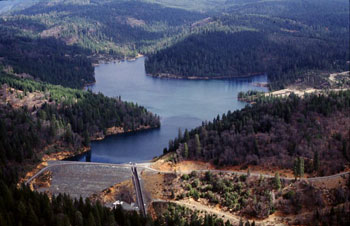
What:
-
205 ft. high dam with crest(top) length of
689 ft.
-
Largest river running through Foresthill.
-
30 miles long.
Where:
-
Sugar Pine located on North Shirttail Canyon.
-
7 miles north of Foresthill, CA.
-
American River Division consists of Folsom,
Sly Park, and Auburn-Folsom South Units.
-
midway between the northern and southern
extremes of the Central Valley in Sacramento, San Joaquin, Placer, and
El Dorado Counties.
-
Flowing South West to the Sacramento River.
Uses:
-
River led to the "California
Gold Rush" in 1849 due to the large quantity of gold it contained.
-
Provide water for irrigation, municipal,
and industrial uses to Foresthill Divide area.
-
Recreation: White water rafting, swimming,
fishing, etc.
Credits: DJ & AS(students in CAiS), CAiS(Computer
Applications in Science) - an elective of Richmond
High School, Science
& Industry Technology Partnership Academy (SITPA)
To send us feedback, please email our
teacher,
Hulda
Nystrom - [email protected]