| Scientific Fishing -- page 3 |
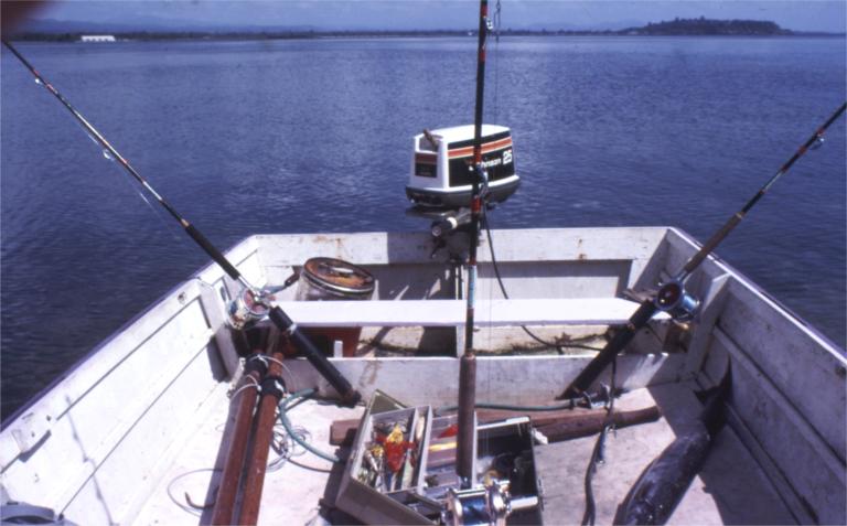
| As I said, David and I were both interested in water-sport. Apart from fishing, there was surfing and diving. Several of us would often body-surf after work at a nearby beach. As the waves were short and steep, we all became expert at riding dumpers without risking our necks. David and I were also part of a group who would regularly scuba-dive. What does this have to do with scientific fishing? Well, the surfing is not part of the story, but the diving certainly is. While diving we occasionally noticed large solitary mackerel swimming just off the edge of a coral reef, in about twenty fathoms of water; they would loiter there waiting for a meal to present itself. Our diving experience also taught us how to judge reefs and the depth of water by its colour. The right place was where the sea changed from green to blue. Sea fishermen usually rely on "marks" to find fishing spots: the fisherman lines up two conspicuous landmarks in one direction and two more in a direction roughly at right-angles to the first. Mostly they find these marks in the first place by accident or with the aid of an echo-sounder. And fisherman usually keep details of these marks secret. How were we to find the fishing hot-spots? I got hold of a marine chart entitled "Approaches to Wewak". This chart covered exactly the area of the Bismarck Sea that interested us, and in very good detail. We pored over the chart, using the contour-lines to identify places we thought would be hot fishing spots: areas where reefs dropped suddenly into deep water. There were plenty of these: the 100-fathom line was only 50 metres or so from shallow reefs in several places. Having identified these hot-spots on the chart, how were we to find them on the water? I had bought a hand-bearing compass, thinking that it would come in handy for general navigation. Using the chart I made up a table which gave cross-bearings to a few conspicuous land-marks. Using these cross-bearings put us approximately in the right spot. The colour of the sea would show exactly where we should be fishing. Having found a good general locality, we would explore the area, trying to find a more-or-less straight run that would keep the boat in the right depth of water. Then we would drop a buoy at both ends of this run and troll between the buoys. All the large mackerel we had seen while diving were in mid-water, not near the surface at all. To ensure that our baits were down where the mackerel were, we used a fairly heavy lead bullet-shaped sinker and trolled very slowly, with the motor not much more than idling. We very quickly learnt that it was important for the bait, which was well-and-truly dead of course, to swim in a lifelike manner. Baits that didn't swim were left untouched and those that looked natural would be attacked. So, we would watch each bait in the water before letting it run out behind the boat. If it didn't swim we would haul it out and manipulate it to straighten out the kinks and make it flexible. We rejected baits that could not be made to swim, as we knew it was a waste of time trolling them. So we had the right place, the right gear and the right bait. The only other element was time. This was, we realised, going to be just after sunrise, which meant being on the water well before sunrise. It was not easy to get out of bed early enough, but we were dedicated to catching fish. |