Highest Mountains in the
World
Ranked in Order
|
Rank |
Feet |
Mountain |
Region |
|
1 |
29,029 |
Everest (Qomolangma Feng) |
China & Nepal |
|
2 |
28,251 |
K2 (Qogir Feng, Godwin Austen) |
China & India |
|
3 |
28,169 |
Kangchenjunga |
India & Nepal |
|
4 |
27,766 |
Makalu |
China & Nepal |
|
5 |
26,906 |
Cho Oyu |
China & Nepal |
|
6 |
26,795 |
Dhaulagiri |
Nepal |
|
7 |
26,781 |
Manaslu |
Nepal |
|
8 |
26,657 |
Nanga Parbat |
India (Kashmir) |
|
9 |
26,545 |
Annapurna |
Nepal |
|
10 |
26,470 |
Gasherbrum |
India (Kashmir) |
|
11 |
26,286 |
Xixabangma (Gosainthan) |
China (Tibet) |
|
12 |
25,869 |
Distaghil Sar |
India (Kashmir) |
|
13 |
25,659 |
Masherbrum |
India (Kashmir) |
|
14 |
25,643 |
Nanda Devi |
India (Kashmir) |
|
15 |
25,551 |
Rakaposhi |
India (Kashmir) |
|
16 |
25,446 |
Kamet |
China & India |
|
17 |
25,446 |
Namcha Barwa |
China (Tibet) |
|
18 |
25,354 |
Gurla Mandhata |
China (Tibet) |
|
19 |
25,338 |
Muztag |
China |
|
20 |
25,325 |
Kongur |
China |
|
21 |
25,230 |
Tirich Mir |
Pakistan |
|
22 |
24,790 |
Gongga Shan |
China |
|
23 |
24,757 |
Muztagata |
China |
|
24 |
24,590 |
Pik Kommunizma |
Tajikistan |
|
25 |
24,406 |
Pik Pobedy (Tomur Feng) |
Kyrgyzstan & China |
|
26 |
22,835 |
Aconcagua |
Argentina |
|
27 |
22,572 |
Ojos del Salado |
Argentina & Chile |
|
28 |
22,546 |
Bonete |
Argentina |
|
29 |
22,205 |
Huascarán |
Peru |
|
30 |
21,463 |
Sajama |
Bolivia |
|
31 |
21,276 |
Illampu |
Bolivia |
|
32 |
20,958 |
Ancohuma |
Bolivia |
|
33 |
20,702 |
Chimborazo |
Ecuador |
|
34 |
20,322 |
McKinley |
USA |
|
35 |
19,524 |
Logan |
Canada |
|
36 |
19,344 |
Cotopaxi |
Ecuador |
|
37 |
19,341 |
Kilimanjaro |
Tanzania |
|
38 |
18,698 |
Citlaltépetl (Orizaba) |
Mexico |
|
39 |
18,606 |
Damavand |
Iran |
|
40 |
18,510 |
El'brus |
Russia |
|
41 |
17,060 |
Kirinyaga (Kenya) |
Kenya |
|
42 |
16,864 |
Vinson Massif |
Antarctica |
|
43 |
16,808 |
Büyükagri (Ararat) |
Turkey |
|
44 |
16,765 |
Stanley (Margherita) |
Uganda & Zaire |
|
45 |
16,503 |
Jaya (Carstensz) |
Indonesia |
|
46 |
15,771 |
Mont Blanc |
France & Italy |
|
47 |
15,584 |
Klyuchevskaya Sopka |
Russia |
|
48 |
15,203 |
Monte Rosa (Dufour) |
Italy & Switzerland |
|
49 |
14,977 |
Meru |
Tanzania |
|
50 |
14,911 |
Dom (Mischabel) |
Switzerland |
|
51 |
14,872 |
Ras Dashen |
Ethiopia |
|
52 |
14,856 |
Kirkpatrick |
Antarctica |
|
53 |
14,787 |
Karisimbi |
Rwanda & Zaire |
|
54 |
14,692 |
Matterhorn |
Italy & Switzerland |
|
55 |
14,495 |
Whitney |
USA |
|
56 |
14,429 |
Elbert |
USA |
|
57 |
14,409 |
Rainier |
USA |
|
58 |
14,177 |
Elgon |
Kenya & Uganda |
|
59 |
13,796 |
Mauna Kea |
USA (Hawaii) |
|
60 |
13,665 |
Toubkal |
Morocco |
|
61 |
13,435 |
Cameroun |
Cameroon |
|
62 |
13,432 |
Kinabalu |
Malaysia |
|
63 |
12,448 |
Erebus |
Antarctica |
|
64 |
12,388 |
Fuji |
Japan |
|
65 |
12,349 |
Cook |
New Zealand |
|
66 |
12,198 |
Teide |
Spain (Canary Islands) |
|
67 |
11,424 |
Mulhacén |
Spain |
|
68 |
11,424 |
Thabana-Ntlenyana |
Lesotho |
|
69 |
11,204 |
Emi Koussi |
Chad |
|
70 |
10,902 |
Etna |
Italy |
|
71 |
7,310 |
Kosciusko |
Australia |
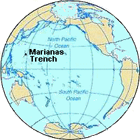
The Marianas Trench
or 'The Challenger Deep'
 The Marianas
Trench:
The Marianas
Trench:
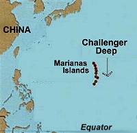
It's the deepest spot in any ocean of the world. It is located in the
Pacific Ocean, just east of the Phillippines.
Nearby is the island of Guam, a U.S. Territory inhabited by natives identified
as Chamorros.
The Marianas trench is sometimes called the 'Challenger Deep' because it was
located and named after His Majesty's Ship 'Challenger' of the British Royal
Navy in the 19th century.
The Marianas Trench's depth is about 10,924 m, or almost 11 km (7
miles). This is a height greater than any mountain on the surface of the earth!
What makes the Marianas Trench so interesting is the reason
why it exists in the first place.
To understand what caused it to be formed will require a little information
about plate tectonics, or the movement of pieces of the earth's crust.
Plate Tectonics is a description of the surface of the
earth. The interior of the earth, called the mantle, is hot, molten
lava. The solid crust, which is in pieces, floats on this magma, much
like the shell of chocolate on a dipped icecream cone sits on the icecream.
As hot magma rises through cracks in the crust, it pushes the pieces of
crust apart. In other places, pieces of crust are forced together, where they buckle
to form mountains.
The oceanic crust is much heavier than the continental
crust, so when these plates crash into each other, the oceanic plate
plunges downward toward the molten mantle, while the lighter, continental plate
rides up over the top. The forces driving the two plates together are really
intense, so the underlying oceanic plate (the 'subducted' plate) creates a trench
where it drags the edge of the continental crust down as it descends
underneath. (check out the picture).
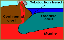
The really deep part of the ocean is in the bottom of the trench created
by this subducting ocean crust. The Marianas Trench, for example, marks where
the fast-moving Pacific Plate converges against the slower moving Philippine
Plate.
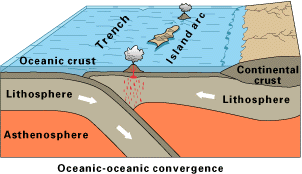
Subduction also results in the formation of volcanoes.
Over millions of years, the erupted lava and volcanic debris from the escaping
magma pile up on the ocean floor, until a submarine volcano rises above
sea-level to form an island volcano. The Phillippines, the Marianas
Islands are examples of this. Such volcanoes are typically strung out in chains
called island arcs. As the name implies, volcanic island arcs, which closely
parallel the trenches, are generally curved. Because of their nearness to the
the tectonic activity below, they experience numerous strong earthquakes.
Volcanoes can also form where the sea-floor crust passes over a 'hot spot' ...
a spot where the crust is very thin and the hot layers below have broken
through. As the moving crust passes over this hot spot, volcanoes form. The
volcanoes sometmes reach all the way to the surface of the ocean, forming
islands. As the crust continues to move, new volcanic islands are formed in
sequence. This is how the Hawaiian Islands were formed; the island of Hawaii is
currently over the hot spot. [Our thanks to Simon Jowitt of Camborne School
of Mines in Cornwall, UK for correcting an error we made here].
|
|
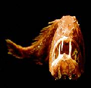
Many strange creatures live in the perpetual dark and
crushing pressure of this deep ocean floor ... but that's the subject of a
future science page!
Longest-Lasting Echo
The longest echo detected in any building lasted 15 seconds. It
was produced by closing the door of the chapel of the Mausoleum in Hamilton,
South Lanarkshire, Scotland, built 1840–55.
Longest River
The Nile is credited as the longest river in the world. Its main
source is Lake Victoria, in east central Africa. From its farthest stream in
Burundi, in eastern Africa, it extends 6,695 km (4,160 miles) in length.
Largest Swamp
The world's largest tract of swamp is the Pantanal, in the states
of Mato Grosso and Mato Grosso do Sul in Brazil. It is about 109,000 sq km
(42,000 sq miles) in area.
Largest River To Dry Up
For several months a year, the 5,464-km (3,442-mile) Yellow River
in China now dries up in Henan province. This is due to below-average rainfall,
increased irrigation, and the industrial demands of a growing population.
Largest Delta
The world's largest delta is that created by the Ganges and
Brahmaputra rivers in Bangladesh and West Bengal, India. It covers an area of
75,000 sq. km. (30,000 sq. miles).
Largest Basin
The largest river basin in the world is that drained by the
Amazon. It covers about 7,045,000 sq km
(2,720,000 sq miles).
Greatest River Flow
The Amazon Basin holds two-thirds of all the flowing water in the
world. This is due to the fact it flows through the Amazon rain forest – the largest
and wettest rain forest on the planet. The river is fed by over 1,000 tributary
rivers, many of which are over 1,600 km (1,000 miles) long.
WANT TO KNOW MORE?
So why is the River Amazon so
huge? Essentially because it is right on the equator. Around the "belt
line" of the Earth lies a warm, tropical zone with over 1,016 cm
(400 in) of rainfall every year. A lot of water falls onto the land
surrounding the river into the "Amazon River drainage basin". Imagine
this drainage basin is like a shallow dish covering the whole northern half of
the South American continent. Whenever rain falls and lands anywhere in the
basin, it all runs into the lowest place in the pan, which happens to be the
Amazon River.
CHECK THIS OUT...
The Amazon Rainforest is the home
of 250 species of mammals, 3,000 freshwater fish, 1,800 birds, 10,000 trees,
and 70,000 other plant species.
1. What country has the longest coastline?
Canada has the longest coastline of
any country. It is 56,453 miles long.
2. Which ocean is the deepest?
The Pacific Ocean has the greatest
average depth of about 4282 meters.
3. What is the longest coral reef?
The Great Barrier Reef, along the
continental shelf of northeastern Australia, is the longest coral reef
measuring about 1,243 miles long.
4. Where is the deepest point on the ocean floor?
The Challenger Deep is the deepest
point at 35,802 feet deep. It is located off the coast of Guam in the Marianas
Trench. This depth was recorded in 1960 by the TRIESTE, a manned submersible
owned by the U.S. Navy.
5. What is the longest river?
The Nile River, in Egypt, Africa,
is 4,160 miles long and flows northward into the Mediterranean Sea.
6. What is the longest mountain range?
The Mid-Ocean Ridge is Earth's
longest mountain range. The ridge circles the globe from the Arctic Ocean to
the Atlantic Ocean passing into the Indian Ocean and crossing into the Pacific
Ocean. This range is four times longer than the Andes, Rocky and Himalaya
Mountains combined.
7. How tall was the tallest iceberg?
The tallest iceberg, measuring 550
feet, was located in 1958 off the coast of Greenland. This iceberg was only 5
feet 6 inches shorter than the Washington Monument in Washington, DC.
10. Which mountain is the tallest?
Although Mount Everest, at 29,028
feet tall, is often called the tallest mountain; Mauna Kea, an inactive volcano
on the island of Hawaii is actually taller. Only 13,796 feet of Mauna Kea
stands above sea level, yet it is 33,465 feet tall if measured from the ocean
floor to its top. Mauna Kea would be 4400 feet taller than Mount Everest if
they were placed next to each other. Also, if Mauna Kea was placed in the
Marianas Trench, there would be about 2,000 feet between its top and the
surface of the ocean.
11. What is the deepest lake?
Baykal Lake in the USSR, just north of Mongolia, is the deepest lake with a maximum depth of 5,315 feet.
The Andes
Mountains are one of the longest and one of the highest mountain ranges in the
world. They are located in South America and stretch 4,500 miles from north to
south, along the west coast of the continent.
The Rocky Mountains, the great backbone of North America, extend
5,000 kilometers from New Mexico to Canada. The elevations range from about
1,500 meters along the plains to 4,399 meters, and the widths range from 120 to
650 kilometers (Lavender 1975).
The Rocky Mountains are composed of many mountain ranges with unique ecological
features. For example, 20 ranges make up the Rocky Mountains in and adjacent to
Wyoming (Knight
1994). The natural beauty, abundant wildlife, and fresh water have
attracted human inhabitants for the last 10,000-12,000 years (Fig. 1).
The Puerto Rico Trench is
the deepest part of the Atlantic Ocean, with water depths exceeding 8,400
meters (figure 1). Its depth is comparable to the deep trenches in the Pacific
Ocean. Trenches in the Pacific are located in places where one tectonic plate
subducts or slides under another one. The Puerto Rico Trench, in contrast, is
located at a boundary between two plates that slide past each other with only a
small component of subduction. The trench is less deep where the component of
subduction is larger. The unusually deep sea floor is not limited to the
trench, but also extends farther south toward Puerto Rico. The Puerto Rico
Trench is also associated with the most negative gravity anomaly on earth, -380
milliGal, which indicates the presence of an active downward force. Finally, a
thick limestone platform, which was originally deposited in flat layers near
sea level, is now tilted northward at a uniform angle. Its northward edge is at
a depth of 4,200 m, and its southern edge can be found on land in Puerto Rico
at an elevation of a few hundred meters. Many tectonic models have been
proposed to explain this geologically fascinating, tectonically active region;
however, none have gained acceptance, and the region remains poorly understood,
largely because its underwater location makes it difficult to study.
|
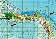
Puerto Rico, the Virgin Islands to its east, and eastern
Hispaniola to its west, are located on an active plate boundary zone between
the North American plate and the northeast corner of the Caribbean plate (figure
1). The Caribbean plate is roughly rectangular, and it slides eastward at about
2 cm/yr relative to the North American plate. Motion along its northern
boundary (in the plate boundary zone region) is dominantly strike-slip (a
geological fault in which an adjacent surface moves horizontally), with a small
component of shortening. In contrast, on its eastern boundary, the Caribbean
overrides the North American plate, creating the island arc of the Lesser
Antilles with its active volcanoes.
|
The geologic settings of Puerto Rico and the Virgin
Islands have created or contributed to several pressing societal issues related
to human safety, environmental health, and economic development. Over 4 million
U.S. citizens live on these islands, mostly along the coast. Because the island
lies on an active plate boundary, earthquakes are a constant threat, and the
densely populated coastal areas are vulnerable to tsunamis. Erosion is a
concern in many coastal areas, but is particularly serious to island economies
that rely heavily on the tourist industry.
The region has high seismicity and large earthquakes (figure 2). Examples
include a magnitude 7.5 earthquake centered northwest of Puerto Rico in 1943,
and magnitude 8.1 and 6.9 earthquakes north of Hispaniola in 1946 and 1953,
respectively. Historically, other large earthquakes have also struck the area,
such as one in 1787 (magnitude~8.1), possibly in the Puerto Rico Trench, and
one in 1867 (magnitude~7.5) in the Anegada Trough (figure 1). A draft U.S.
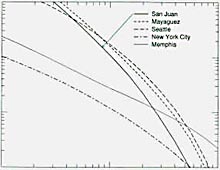
Geological Survey (USGS) hazard map places equal probability for damaging
ground motion for Mayaguez in western Puerto Rico as for Seattle, Washington.
Other Puerto Rican cities also have substantial risk.
|
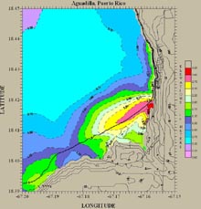
The
hazard from tsunamis is also apparent. Immediately after the 1946 earthquake, a
tsunami struck northeastern Hispaniola and moved inland for several kilometers.
Some reports indicate that nearly 1,800 people drowned. A 1918 magnitude 7.5
earthquake resulted in a tsunami that killed at least 91 people in northwestern
Puerto Rico (figure 4). Eyewitness reports of an 1867 Virgin Islands tsunami
gave a maximum wave height of >7 m in Frederiksted, St. Croix, where a large
naval vessel was left on top of a pier. Essentially, all of the known causes of
tsunamis are present in the Caribbean -- earthquakes, submarine landslides,
submarine volcanic eruptions, subaerial pyroclastic flows into the ocean, and
major tsunamis called teletsunamis. Because of its high population density and
extensive development near the coast, Puerto Rico has a significant risk for
earthquakes and tsunamis.