| Sudanese
Facts
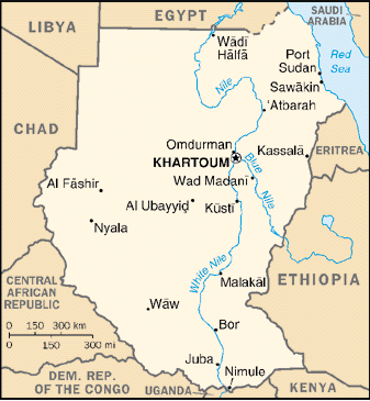
Sudan is located on Northern East Africa,With
Cordination of 15 00 N, 30 00 E, bordering 8 countries, Egypt 1273
Km (North),Eritrea 605 Km and the Red Sea 853 Km (East),Ethopia
(SE), Kenya 232 Km and Uganda 435 Km (South), Central Africa
Republic 1165 Km , Chad 1360 Km (West), and Libya
383 Km (NW).
Total area is 2,505,810
sq km
land constitutes 2.376 million sq km
waterconstitutes
129,810 sq km of the area.
Irrigation System
The Great Nile river and
its subsidiaries constitutes a large irrigation system. Runnung from South and East
towards North covering a large area of land. There are many Dams on it for Irrigation and
Electercity purposes.
The Northis arid, while the South is
tropical.The Rainy season from April to October
|
Natural Resources
|
|
Oil :
|
Utilized by a consortium of many companies
from Canda,Malasya,Qatar,... etc.Many fields
are in the West ans South West.Exportation will start in July 1999 (appox. 150,000 P/D).
A great long pipeline carrying it from South west to
the Refinery in Centre . |
|
Gold :
|
Now is utilized in East (Utilized by French
Companies (Approx. 5 Tonns/Year) .Also it
is available in some different areas. |
|
Small reserves
|
of iron ore, copper,
chromium ore, zinc, tungsten, mica, silver. |
| Population |
Population:
|
38,114,160 (July 2003 est.) |
| Birth rate: |
36.48 births/1,000 population (2003 est.) |
| Population growth rate: |
2.71% (2003 est.) |
| Projected population in 2025: |
61,338,891 (2025 estimate) |
| Projected population in 2050:
|
84,192,309 (2050 estimate) |
| Age structure: |
0-14 years: 45% (male 7,769,266; female 7,449,510)
15-64 years: 52% (male 8,818,018; female 8,778,485)
65 years and over: 3% (male 410,170; female 325,103) (July 1998 est.)
|
| Sex ratio: |
at birth: 1.05 male(s)/female
under 15 years: 1.04 male(s)/female
15-64 years: 1 male(s)/female
65 years and over: 1.26 male(s)/female (1998 est.) |
| Population density 39 persons per sq mi (2003
estimate) |
15 persons per sq km (2003 estimate) |
| Urban/rural distribution |
Share urban 37 percent (2001 estimate)
Share rural 63 percent (2001 estimate) |
| Largest cities, with population |
|
| |
Omdurman |
1,267,077 (1993) |
| |
Khartoum |
2,731,000 (2000 estimate) |
| |
Port Sudan |
305,385 (1993) |
| |
Kassalā |
234,270 (1993) |
| |
Nyala |
228,778 (1993) |
|
Nationality:
|
noun: Sudanese
(singular and plural)
adjective: Sudanese |
|
Ethnic groups:
|
black 49%, Arab 39%, Nubians 8%, Beja
3%,
others 1% |
|
Religions:
|
Sunni Muslim 70% (in north),
indigenous beliefs 12%, Christian 15% (mostly in south and Khartoum), Others
3% |
|
Languages:
|
Arabic (official), Nubian, Ta
Bedawie, diverse dialects of Nilotic, Nilo-Hamitic, Sudanic languages, English
|
| Helath |
| Death rate: |
9.59 deaths/1,000 population
(2003 est.) |
| Infant mortality rate: |
total: 65.59 deaths/1,000 live births
female: 64.85 deaths/1,000 live births (2003 est.)
male: 66.3 deaths/1,000 live births |
| Life expectancy:
|
56.6 years (men), 58.9 years (women) (UN) |
| Total fertility rate: |
5.1 children born/woman (2003
est.) |
| HIV/AIDS - adult prevalence rate: |
2.6% (2001 est.) |
| Education expenditure as a share of gross national product (GNP) |
0.4 percent (1998) |
|
Literacy:
|
age 15 and over can read and write
total population: 61.1%
male: 71.8%
female: 50.5% (2003 est.) |
| Number of years of compulsory schooling |
8 years (2000) |
| Number of students per teacher, primary school |
27 students per teacher (1999-2000) |
| Electricity production
|
|
Electricity from thermal sources
|
52.09 percent (2001 estimate) |
|
Electricity from hydroelectric sources
|
47.91 percent (2001 estimate) |
|
Electricity from nuclear sources
|
0 percent (2001 estimate) |
|
Electricity from geothermal, solar, and wind sources
|
0 percent (2001 estimate) |
| Communications |
|
Number of telephones per 1,000 people |
14 (2001)
Service Provider :
Sudatel |
Mobile cellular:
|
20,000 (2000)
Service Provider:
Mobitel |
|
Telephone system:
|
large, well-equipped system
by African standards, but barely adequate and poorly maintained by modern standards
domestic: consists of microwave radio relay, cable, radiotelephone communications,
tropospheric scatter, and a domestic satellite system with 14 earth stations
international: satellite earth stations�1 Intelsat (Atlantic Ocean) and 1
Arabsat |
|
Radio broadcast stations:
|
AM 11, FM 0,
shortwave 0 |
| Number of radios per 1,000 people |
406 (2000 estimate) |
|
Television broadcast stations:
|
3 Stations |
| Number of televisions per 1,000 people |
239 (2000 estimate) |
|
Internet users:
|
56,000 (2001) |
| Transportation |
Railways:
|
total: 5,978 km
narrow gauge: 4,578 km 1.067-m gauge; 1,400 km 0.600-m gauge plantation
line (2002) |
|
Highways:
|
total: 11,900 km
paved: 4,320 km
unpaved: 7,580 km (1996 est.) |
|
Paved road as a share of total roads |
36 percent (1999) |
|
Number of motor vehicles per 1,000 people |
12 (1997) |
|
Waterways:
|
5,310 km navigable |
|
Pipelines:
|
gas 156 km; oil 2,297 km; refined products 810 km (2003) |
|
Ports and harbors:
|
Juba, Khartoum, Kusti,
Malakal, Nimule, Port Sudan, Sawakin |
|
Merchant marine:
|
total: 4 ships (1,000 GRT or over) totaling 38,093 GRT/49,727 DWT
ships by type: cargo 2, roll-on/roll-off cargo 2 (1997 est.)
|
|
Airports:
|
65 (1997 est.) |
|
Airports�with paved runways:
|
total: 12
over 3,047 m: 1
2,438 to 3,047 m: 8
1,524 to 2,437 m: 3 (1997 est.) |
|
Airports�with unpaved runways:
|
total: 53
1,524 to 2,437 m: 13
914 to 1,523 m: 29
under 914 m: 11 (1997 est.) |
Heliports: 1 (1997 est.)
|