PROCEEDINGS INDONESIAN SEDOMENTOLOGISTS FORUM. 2nd regional seminar, Bandung 1999.
Herman Darman (Shell EP Companies in Indonesia)
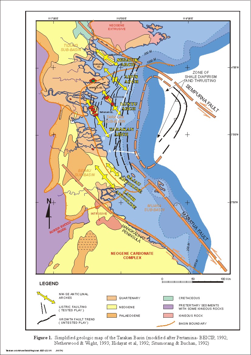
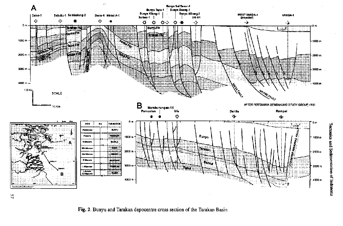
The Tarakan basin is generally a passive deltaic margin with a minor wrench tectonic over print, located in the North East Kalimantan. Oligocene and Miocene sediments thin westward and eventually onlap onto an Eocene Rift sequence. The Tarakan basin is divided into four sub-basins (Figure 1): Muara sub-basin, the southemmost depocentre developed exclusively offshore; Berau sub-basin mostly onshore and located in the south; Tarakan sub-basin, mostly offshore but including Bunyu and Tarakan Js- lands; and Tidung sub-basin, the most northerly basin and mainly onshore. The NW-SE treading Muara sub-basin is bounded to the SW by a wrench fault zone along the north shore of the Mangkalihat Peninsula. Towards the NE the Muara sub-basin is bounded by another wench fault zone which causes a basement high upon which the Maratua reefal islands have developed (Figure 1). Seismic data suggests the presence of 5000 metres of Oligocene to Recent carbonate rift and passive margin sediments in the Muara Sub-basin, resting on older volcanics. Little structuration is present in the Middle Miocene to Recent post rift portion of the section. 1be Berau sub-basin is bounded to the north and south by Pre-Tertiary outcrops. 1he southern margin, is the igneous Suikerbrood Ridge. East- wards the basin extends into the Tarakan Sub-basin (Figure 1). 1he division between the Tarakan and Berau Sub-basins is based upon the pinch-out of the Tarakan Formation of Pliocene age. Several NNW-SSE trending compressional features are present within the Berau Sub-basin. This structuration is related to left lateral movement along wrench zones accommodating the on- going spreading of the Makassar Strait. The thick clastic fill in the Tarakan sub-basin is an amalgamation of numerous Plio-Pleistocene clastic depocentres located below Bunyu and Tarakan islands and prograding further offshore (Figure 2). The Pliocene thins regionally to the west and south, onlapping Miocene highs and eventually pinching out. The Tidung Sub-basin is separated from the Tarakan Sub-basin by a carbonate platform, as de6ned by the northern pinchout of the Tarakan Formation. The Tidung sub-basin contains several NW trending tightly folded anticlines. thrusting also occurs along the coast In the north it is bounded by the Semporna fault zone exhibiting sinistral transform movement. The Tarakan Basin was initiated simultaneously with the formation of the Sulawesi Sea by rifting of north and west Sulawesi from east Kalimantan. Extension and subsidence began during the Middle to Late Eocene and had stopped by the end of the Early Miocene (Burollet and Salle, 1981; Situmorang, 1982, 1983). This extensional tectonic phase opened the Tarakan Basin east- ward as indicated by the predominance of enechelon block faulting heading to the east. 7he opening of the Sulawesi Sea has been interpreted as being related to the same tectonic episode responsible for the opening of the South China Sea (Rangin, 1991). Clastic sediments were transported from the Suikerbrood Highs to the northeast down to the basin during Late Eocene. Signi6cant carbonate sequence of Seilor-Formation developed intensively m the entire area during Early Oligocene and overlain by Mangkabua Shales during Late Oligocene. During Early Miocene the Tabalar Formation is encased in shales of the Birang Formation and the time equivalent Naintupo Formation due to the continuing transgression. 1he Tarakan Basin was more tectonically stable from the Mid. Miocene until the Pliocene with deltaic sedimentation from the west through several drainage systems. 1he delta front facies developed both in the north and south o f the basin, named Latih and Meliat Formation (Rustam, 1977), continued by eastward prograding deltaic complex. In the south carbonate complex developed well during Late Miocene. During this phase the combination of basin subsidence and gravity induced listric faulting (growth faults) created accommodation space for an increased volume of deltaic sediments. The growth faults are the most common structure in the Tarakan Sub-basin (Fig. 2). The faulting trends north-south in the southern portion of the basin, and changes to a more northeasterly orientation north of Bunyu Island. This change in orientation corresponds to the edge of the northerly Plio-Pleistocene depocentre. Here the faults are more laterally continuous and exhibit maximum displacement, A regional seismic dip line (Figure 2) shows the typical expression of the extensional regime and the north-south fault syste. The Tarakan and Sajau Formations of Pliocene age are composed of marine to supralittoral clastics and coals. These formations become carbonate dominated in the distal prodelta offshore, east of the Tarakan Sub-basin. The guarternary Bunyu and Waru Formations were deposited after the general marine onlap caused a global rise of sea level. This transgression has shifted back the Plioceae deltas westward adjacent to the present coastline. The latest tectonism phase is a reactivation of transform movement along the wrench faults crossing the Makassar Strait beginning in the uppermost Pliocene and continuing to present day. Three major dextral wrench fault zones, and several smaller scale wrench Faults are found in the Tarakan Basin. The Sempoma fault zone is the most northern wrench zone. 1t separates tbe volcanics of the Sempoma Peninsula from the Neogene sediments on Sebatik Island (Fig. 1). Further onshore it become a boundary between Cretaceous sediments in the north and Neogene sediments in the south. 'Ihe Maratua Fault zone occurs as a complex transpressional zone. It forms the boundary between the Tarakan and Muara Sub-basins (Fig. 1). The third major wrench fault forms the southern boundary of Muara Sub-basin, along the north shore of the Maagkalihat Peninsula. It appears as the extension of the Palu-Koro fault in Sulawesi (Fig. 1). Transpression during this period resulted in the formation of major dip oriented arches. Vitrinite reflectance, porosity and seismic data suggest approximately 1000 m of structural inversion occurred during arch formation. Five major arches dominate the western area, informally named firom north to south, the Sebatik, Ahus, Bunyu, Tarakan and Latih arches (Fig. 1). They are broad SE plunging flexures formed by NE-SW transpression and are oriented roughly NNW - SSE, changing to NW - SE further northwards. The age of compression appears to get younger northwards and is coeval with, but decoupled from, the major extensional system to the east. The intensity of folding also increases northwards where the broad arches give way to tight folds in the onshore area. The Latih arch and minor anticlines develop in the southern part of the Tarakan Basin. They are NW-SE oriented. These anticlines have been drilled and had oil shows and gas flows from thin turbidite sand stones.