-Africa-
Africa straddles the equator and stretches from Cape Blanc in the north to Cape Agulhas in the south. The Sinai Peninsula connects it with Asia and the Mediterranean Sea, on the west and south by the Atlantic Ocean and on the east and south bound it on the north by the Indian Ocean. The largest offshore island is Madagascar, other islands include St. Helena and Ascension in the south Atlantic Ocean, Sao Tome, Principe, Annobon, and Bioko in the Gulf of Guinea, the Cape Verde, Canary, and Madeira islands in the north Atlantic Ocean, and Mauritius, Reunion, Zanzibar, Pemba, and the Comoros and Seychelles in the Indian Ocean.
-Egypt-
Situated at the northeastern corner of Africa, Egypt is bordered on the north by the Mediterranean Sea, in the east by Israel and the Red Sea, in the south by Sudan, and to the west by Libya. The altitude of Egypt ranges from 132 miles below sea level in the Libyan Desert to about 2,629 miles at Mount Catherine in the Sinai Peninsula. The Nile delta is a broad alluvial land, sloping to the sea for 100 miles, with a 155 miles maritime front between Alexandria and Port Sa�id. South of Cairo, most of the country is a tableland rising to some 457 miles, and cliffs as high as 548 miles enclose the narrow valley of the Nile. A serious of cascades and rapids at Aswan, known as the First Cataract, forms a barrier to movement upstream. The Sahara, which north of Aswan is usually called the Libyan Desert, east of the Nile, covers the bulk of the country, the Arabia Desert extends to the Red Sea. The Western Desert consists of low-lying sand dunes and many depressions. The outstanding geographical feature is the Nile River, on which human existence depends for its annual floods provide the water necessary for agriculture.
-South Africa-
South Africa lies at the southernmost part of the African continent. Botswana and Zimbabwe border it to the north, to the north by Mozambique and Swaziland and to the northwest by Namibia. On the east coastline lies the Indian Ocean, the southern coastline the confluence of the Indian and Atlantic Oceans, and Atlantic Ocean on the western side. South Africa completely surrounds Lesotho. Most of South Africa has elevations of over 914 miles and at least 40% of the surface is at an elevation of ever 1,220 miles. Parts of Johannesburg are 1,829 miles above the sea level. Resembling an inverted saucer, the land rises steadily from west to east to the Drakensberg Mountains, the tallest of which is Mont-aux-Sources at 3,300 miles. The coastal belt in the west and south varies from 3 to 30 miles in width, is between 152 miles to 182 miles above sea level, and is very fertile, producing citrus fruits and grapes, particularly in the Western Cape. North of the coastal belt stretch, the Little and the Great Karol, which are bounded by mountains.
-Libya-
Libya is situated on the coast of North Africa and is the fourth largest country on the continent. It borders with Egypt in the east, Sudan in the southeast, Chad and Niger in the south, Algeria to the west and Tunisia in the northwest and the Mediterranean Sea in the north. Libya forms part of the North African plateau extending from the Atlantic Ocean to the Bed Sea. The highest poing is 10,335 feet, a peak in the extreme south. The main geographical areas are Tripoli Tania, Cyrenaica, and Fezzan. Tripoli Tania consists of a series of terraces rising slowly from sea level along the coastal plain of the Jakarta to sharp escarpments commonly called the Cabal. These are the most important agricultural areas of Tripoli Tania. South of the Cabal is an upland plateau of sand, scrub and scattered masses of stone. Further south are depressions extending from east to west. Here are found many oases and artesian wells. An upland plateau rising to 2,000 feet gives a rugged coastline to Cyrenaica. This plateau, the Green Mountain contains three of Libya's leading cities-Benghazi, El Banda and Darnah. Further south, the desert is studded with oases such as Jalu and Jaghbub. South of Cyrenaica are the Tibetan Mountains. The Fezzan is largely a series of depressions with occasional oases. There are no perennial rivers in the whole country.
-Algeria-
Algeria is the second-largest country in Africa and it is situated in northwestern Africa, with the northern coastline running along the Mediterranean Sea. Tunisia and Libya border it on the east, on the southeast and south by Niger, on the south and southwest by Mali, on the west by Mauritania and on the west by Marco. The northern parallel mountain ranges of the Saharan Tell or Maritime Atlas, comprising coastal massifs and inland ranges, and the Saharan Atlas divide Algeria into three longitudinal zones running generally east and west: the Mediterranean zone, the high plateaus, and the Sahara which covers some 85% of the entire area. About half of Algeria are 914 miles or more above sea level, and about 70% of the area if from 762 miles to 1675 miles in elevation. The lowest point is Cot Melrhir-40 miles and the highest Tahiti at 3,003 miles. Only the main rivers of the Tell have water all year round, and even then the summer flow is small. None the rivers are navigable. The mountainous area of the High Plateaus are poorly watered, most of the rivers and streams flow irregularly, since they depend on erratic rainfall for water. In the High Plateaus lie many salt marshes and dry or shallow lakes. Further south, the land becomes increasingly arid, merging into the completely dry Sahara Desert.
-Asia-
Asia, the world's largest continent, 17,139,000 square miles, with about 3.3 billion people, nearly three fifths of the world's total population. Climate and topography, with the monsoons and the fertile alluvial plains determining the areas of greatest density govern the distribution of Asia's huge population. Such are the Ganges Plain of India and the Chang River and northern plain of China, the small alluvial plains of Japan, and the fertile volcanic soils of Java and Indonesia. Urbanization is greatest in the industrialized regions of Japan, Korea, and Taiwan, but huge urban centers are to be found throughout the continent. Although Asia's economy is predominantly agricultural, regions where power facilities, trained labor, modern transport, and access to raw materials are available have developed industrially. Japan, China, Russian Asia, South Korea, Taiwan, Turkey, and Israel are distinguished for their industrialization. China and India are making considerable strides in this direction. The most spectacular industrialization has occurred in Japan, Taiwan, Korea, Singapore, and Hong Kong. The economies of Thailand, Indonesia, and South China are booming thanks to Japanese investment in plants and to cheap indigenous labor. The development of railroads is greatest in the industrialized countries, with Japan, China, India, and Russian Asia having the greatest track mileage.
-Australia-
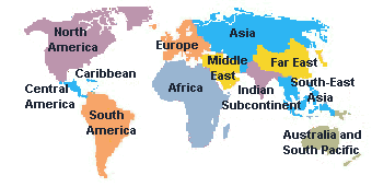
Introduction -Europe- -North America-
-South America-
-Chile-
-China-
Officially People's Republic of China. The most populous country in the world. China has a 4,000 miles coast that fronts on the Yellow Sea, the East China Sea, and the South China Sea. Russia and North Korea elsewhere bound it on the east, on the north by Russia and Mongolia, on the west by Tajikistan, Kyrgyz Stan, Kazakhstan, Pakistan, and Afghanistan, on the south by India, Nepal, Bhutan, Myanmar, Laos, and Vietnam. China's capital is Beijing; Shanghai is its largest city. China is one of the world's major mineral-producing countries. Coal is the most abundant mineral, high-quality, easily mined coal is found throughout the country, but especially in the north and northeast. There are also extensive iron-ore deposits; the largest mines are at Ashen and Benxi, in loaning province. China used to import about 90% of its petroleum, but oil fields discovered since the 1960s have made the country a net exporter. By the early 1990s, China was the world's fifth-ranked oil producer. Off shore exploration has also become important, massive deposits off the coasts are believed to exceed the entire world's known oil reserves. The Han Dynasty made up approximately 92% of the total population. They are linguistically homogeneous in the north, where they speak Mandarin, while in the south speak Cantonese. The written language is universal, Chinese ideographs are common to all the dissects. To the extent that a general statement about the climate of such a large country can be made, China may be described as wet in the summer and dry in the winter. Regional differences are found in the highlands of Tibet, the desert and steppes if Xinjiang and Inner Mongolia, and in China proper.
-Japan-
Occupying an archipelago off the coast of East Asia. The capital is Tokyo, which along with neighboring Yokohama forms the world's most populous metropolitan region. Japan's principal religions are Shinto and Buddhism. Most Japanese adhere to both faiths. While the development of Shinto was radically altered by the influence of Buddhism, which was brought from China in the sixth century. Japan's farming population has been declining steadily and was about 6% of the total population in the 1990s; agriculture accounted for only 2% of the GNP. Arable land is intensively cultivated, farmers use irrigation, terracing, and multiple cropping to coax rich crops from the overworked soil. Rice and other cereals are the main crops, some vegetables and industry crops are also grown, and livestock is raised.
-Singapore-
It consists of the island of Singapore and about 60 small adjacent islands at the southern tip of the Malay Peninsula, Southeast Asia Singapore city, the capital, the largest city, and the chief port, is administratively coextensive with the republic. The distinction between Singapore and Singapore City has virtually disappeared, as almost the entire island has become urbanized. Singapore is one of the world's greatest commercial centers, with a large, modern port. Commerce has historically been the chief source of income. For many years the largest importer in Southeast Asia. Singapore is a free port and an entrepot that exports more than half of what it imports, notably rubber, petroleum, textiles, timber, and tin. It also exports locally manufactured goods such as computer and telecommunications equipment, petroleum products, oil drilling equipment, plastics, rubber products, and processed food and beverages. The country imports most of its food requirements.
-India-
India's land frontier stretches from the Arabia Sea on the west to the Bay of Bengal in the east and touches Pakistan, China, Nepal, and Bhutan. Bangladesh, which forms an enclave in the northeast, and Myanmar. New Delhi is India's capital and Bombay is its largest city. Most towns are connected by state-owned railroad systems, one of the most extensive networks in the world. The train system is made mainly of broad-gauge track but includes a variety of rail gauges, which makes frequent transshipment necessary. The country is in the process of converting all tracks to broad gauge. Transportation by road is increasing, with the improvement of highways and the introduction of ordinary and luxury bus service on long-distance routes, but in rural India the bullock cart is still an important means of transportation. There are international airports at New Delhi, Calcutta, Kochi, and Vishakhapatnam. The leading exports are gems and jewelry, clothing, engineering goods, chemicals, cotton thread, fabric, and handicrafts. The chief imports are machinery, petroleum, fertilizers, and chemicals.
Australia became a commonwealth of the British Empire in 1901. It was able to take advantage of its natural resources and to make a major contribution to the British effort in World War I and World War II. Long-term concerns include pollution, particularly depletion of coastal areas, especially the Great Barrier Reef. A referendum to change Australia's status, from a commonwealth headed by the British monarch to an independent republic, it was defeat in 1999.
Geography
Australia is the world��s smallest continent. It is the sixth largest country. It is a continent between the Indian Ocean and the South Pacific Ocean. It has a tropical climate in the north part, generally arid to semiarid, and temperate in the south and east.
History
Australia was uninhabited before stone-culture peoples arrived, perhaps by boat across the waters separating the island from the Indonesia archipelago about 40,000 years ago. Portuguese, Spanish, Dutch, and English explorers observed the island before 1770, when Captain Cook explored the east coast and claimed it for Great Britain.
On January 26, 1788, the First Fleet under Captain Arthur Phillip landed at Sydney, and formal proclamation of the establishment of the Colony of New South Wales followed on February 7. Many but by no means all of the first settlers were convicts, condemned for offenses that today would often be thought trivial. The mid-19th century saw the beginning of government policies to emancipate convicts and assist the immigration of free persons. The discovery of gold in 1851 led to increased population, wealth, and trade.
The six colonies that now constitute the states of the Australian Commonwealth were established in the following order: New South Wales, 1788; Tasmania, 1825; Western Australia, 1830; South Australia, 1836;Victoria, 1851; and Queen land, 1859.
Settlement had proceeded these dates in most cases. Discussions between Australian and British representatives led to adoption by the British Government of an act to constitute the Commonwealth of Australia in 1900. The first federal parliament was opened at Melbourne in May 1901 by the Duke of York (King George V). In May 1927, the seat of government was transferred to Canberra, a planned city designed by an American, Walter Burley Griffin. The first session of Parliament in that city was opened by another Duke of York (King George VI). Australia passed the Statue of Westminster Adoption Act on October 9, 1942, which officially established Australia��s complete autonomy in both internal and external affairs. It passage formalized a situation that had existed for years. The Australia Act (1986) eliminated the last vestiges of British legal authority.
Flag Description
Blue with the flag of the United Kingdom in the upper hoist-side quadrant and a large sever-pointed stars in the lower hoist-side quadrant; the remaining half is a representation of the Southern Cross constellation in white with one small five-pointed stars and four, large seven pointed stars.
Economy
Australia has a prosperous Western-style capitalist economy, with a per capita GDP at the level of the four dominant West European economies. It is rich in natural resources. Australia is a major exporter of agricultural products. Minerals, metals, and fossil fuels. Commodities account for57% of the value of total exports, so that downturn in world commodity prices can have a big impact on the economy. The government is pushing for increased exports of manufactured goods, but competition in international markets continue to be server. While Australia has suffered from the low growth and high unemployment characterizing the OECD countries in the early 1990s and during the recent financial problems in East Asia, the economy has expanded at a soled 4% annual growth pace in the last five years. Canberra��s emphasis on reforms is a key factor behind the economy��s resilience to the regional crisis and it��s stronger than expected growth rate. Growth in 2001 will depend on key international commodity prices, the extent of recovery in nearby Asians economies, and the strength of European market and US.
Government
The Commonwealth government was created with a constitution patterned partly on the US Constitution. The powers of the Commonwealth are specifically defined in the constitution, and the residual powers remain with the states.
Australia is an independent nation within the Commonwealth. Queen Elizabeth II is the sovereign and since 1973 has been officially styled ��Queen of Australia��. A governor general and a governor in each state represent the queen throughout Australia.
The federal parliament is bicameral, consisting of a 76 member��s senate and a 148 member House of Representatives. 12 senators from each state and two from each territory are elected for 6-year terms, with half elected every 3 years. The members of the House of Representatives are allocated among the states and territories toughly in proportion to population. In ordinary legislation, the two chambers have coordinate powers, but all proposals for appropriating revenue and imposing taxes must be introduced in the House of Representatives. Under the prevailing Westminster parliamentary system, the leader of the political party wins a majority of the seats in the House of Representative named Prime Minister. The Prime Minister and the cabinet wield actual power and responsible to the parliament. A premier, who is the leader of the party with a majority, heads each state. Australia also has two self-governing territories, the Australia Capital Territory and the Northern Territory, with political systems similar to those of the states.
It is actually a vast peninsula of the great Eurasian landmass. By convention, it is separated from Asia by the Urals and the Ural River in the east, by the Caspian Sea and the Caucasus in the southeast, and by the Black Sea, the Bowsprits, the Sea of Marmora, and the Dardanelle in the south. The Mediterranean Sea and the Strait of Gibraltar separate it from Africa. Europe is washed in the north by the Arctic Ocean and in the west by the Atlantic Ocean, with which the North Sea and the Baltic Sea are connected.
-England-
The largest and most populous portion of the United Kingdom of Great Britain and Northern Ireland. Wales and the Irish Sea bound it on the west and Scotland on the north. The English Channel, the Strait of Dover, and the North Sea separate it from the continent of Europe. The Isle of Wight, off the southern mainland in the English Channel, and the Scaly Islands, in the Atlantic Ocean off the southwestern tip of the mainland, are considered part of England. Landon, the capital of Great Britain, is located in the southeastern portion of England. The Thames and the Severn are the longest rivers.
-France-
France is bordered by the English Channel, the Atlantic Ocean and the Bay of Biscay, Spain and Andorra, the Mediterranean Sea, Switzerland and Italy, and Germany, Luxembourg, and Belgium. The natural land frontiers are the Pyrenees, along the border with Spain, the Jury Mountains and the Alps, along the border with Switzerland and Italy, and the Rhine River, which is part of the border with Germany. France��s capital is Paris. France is one of the world��s major economic powers. Agriculture plays a larger role than in the economies of most other industrial countries. A large proportion of the value of total agricultural output derives from livestock. The mountain areas and northwest France are the livestock regions. The country��s leading crops are wheat, sugar beets, corn, barley, and potatoes, with the most intensive cultivation north of the Loire; the soil in the Central Massif is less fertile. Fruits growing are important in the south. France is among the foremost producers of wine in the world.
-Spain-
It consists of the Spanish mainland, which occupies the major part of the Iberian Peninsula of the Balearic Islands in the Mediterranean Sea, and of the Canary Islands in the Atlantic Ocean. Spain is divided into 50 provinces. The division into 17 geographic and historic regions, generally corresponding to the old Christian and Moorish kingdoms of Spain, has been maintained for most practical purposes.
-Germany-
Located in the center of Europe. The official capital is Berlin, but many administrative functions are still carried on in Bonn, the former capital of West Germany. The Federal Republic of Germany has for many years benefited from a highly standard of living and an extensive social welfare program. Since unification, has Germany faced the economic challenge of transforming the former East Germany from a deteriorating command economy dependent on low-quality heavy industrial products to a technologically advanced market economy. The reconstruction and integration of the country��s economy is widely thought to require carefully calibrated economic policies to entice investment capital to the east without disturbing the western half��s continued economic growth.
-Italy-
The country includes the large Mediterranean islands of Sicily and Sardinia and several small islands, notably Elba, Capri, Itchier, and the Lipari Islands. Vatican City and San Marino are two independent enclaves on the Italian mainland. Rome is the capital. Italy began to industrialize late in comparison to other European nations and until World War II was largely so that by the 1990s industry contributed about 35% of the annual gross domestic product and agriculture less that 4%. The principal farm products are fruits, sugar beets, corn, tomatoes, potatoes, soybeans, grain, olives and olive oil, and livestock. In addition, much wine is produced from grapes grown throughout the country. There is a small fishing industry.
-Sweden-
It borders on Norway in the west, on Finland in the northeast, on the Gulf of Bothnia in the east, on the Baltic Sea on the south, and the Skagerrak in the southwest. Stockholm is Sweden��s capital. Sweden is a highly industrialized country and has one of the highest living standards in the world. Since 1940 there has been a great moment of workers from farms to cities, nevertheless, agricultural output has increased considerably with the application of scientific farming methods. In the 1990s manufacturing contributed about 20% of the annual national income and agriculture about2%. Transportation, communication, and trade are also important. Farming is concentrated in the southern part of the country; the leading commodities produced are dairy products, grain, sugar beets, and potatoes. Large numbers of poultry, hogs, and cattle are raised.
It is the third largest continent, the northern of the two continents of the Western Hemisphere. North America includes all of the mainland and related offshore islands lying North of the Isthmus of Panama. The term ��Anglo-America�� is frequently used in reference to Canada and the United States combined, while the term ��Middle America�� is used to describe the region including Mexico, the republics of Central America, and the Caribbean. The continent is bounded on the north by the Artic Ocean, on the west by the Pacific Ocean and the Bering Sea, and on the east by the Atlantic Ocean and the Gulf of Mexico, Hudson Bay is by far the largest body of water indenting the continent; others include the Gulf of St. Lawrence and the Gulf of California. There are numerous islands off the continent��s coasts; Greenland and the Arctic Archipelago, the Greater and Lesser Antilles, the Alexander Archipelago, and the Aleutian Islands are the principal groups. Mt. McKinley, Alaska, is the highest point on the continent.
-Canada-
Canada occupies all of North America north of the United States except for Greenland and the French islands of St. Pierre and Miquelon. The Atlantic Ocean, on the north bound it on the east by the Arctic Ocean, and on the east by the Pacific Ocean and Alaska. A transcontinental border formed in part by the Great Lakes divides Canada from the United States, Mares and Davis straits separate Canada from Greenland. The Arctic Archipelago extends far into the Arctic Ocean.
Canada has a very long and irregular coastline, Hudson Bay and the Gulf of St. Lawrence indent the East Coast and the Inside Passage extends along the West Coast. The ice-clogged straits between the islands of north Canada form the Northwest Passage. During the Ice Age all of Canada was covered by a continental ice sheet that scoured and depressed the land surface, leaving a covering of glacial drift, depositional landforms, and innumerable lakes and rivers. Aside from the Great Lakes, which are only partly in the country, the largest lakes of North America--Great Bear, Great Slave, and Winnipeg--are entirely in Canada. The St. Lawrence is the chief river of east Canada. The Saskatchewan, Nelson, Churchill, and Mackenzie River systems drain central Canada and the Columbia, Fraser, and Yukon rivers drain the western of the country.
Since World War II the development of Canada��s manufacturing, mining, and service sectors had led to the creation of an affluent society. Manufacturing is Canada��s mist important economic activity. The United States is by far Canada��s leading trade partner, followed by Japan and Great Britain. Manufactured goods comprise the bulk of imports, crude petroleum and motor vehicles and parts rank high among both the nations�� largest imports and exports. Other important exports are newsprint, lumber, wood pulp, wheat, machinery, aluminum, natural gas, hydroelectric power, and telecommunications equipment.
-United States-
Officially United States of America, republic, North America. The United States is the world��s third largest country in population and the fourth largest country in area. It consists of 50 states and a federal district. The conterminous United States stretches across central North America from the Atlantic Ocean on the east to the Pacific Ocean on the west, and from Canada on the north to Mexico and the Gulf of Mexico on the south. The state of Alaska is located in extreme northwest North America between the Arctic and Pacific Ocean, and Canada borders it on the east. The state of Hawaii, an island chain, is situated in east central Pacific Ocean southwest of San Francisco. Washington. D.C., is the capital of the United States, and New York is its largest city.
The conterminous United States may be divided into sever broad hypsographic divisions: from east to west, the Atlantic-Gulf Coastal Plain, the Appalachian Highlands, the Interior Plains, the Interior Highlands, the Rocky Mountain System, the Intermundane Region, and the Pacific Mountain System. An eighth division, the Laurent Ian Uplands, a part of Canadian Shield, dips into the United States from Canada in the Great Lakes region. It is an area of little local relief, with an irregular drainage system and many lakes, as well as some of the oldest exposed rocks in the United States.
-Mexico-
Officially United Mexican States, republic. It borders on the United States in the north, on the Gulf of Mexico and the Caribbean Sea in the east, on Belize and Guatemala in the southeast, and on the Pacific Ocean in the south and west. Mexico is divided into 31 states and the Federal District, which includes most of the country��s capital and largest city, Mexico City.
Most of Mexico is highland or mountains and less that 15% of the land is arable, about 25% of the country are forested. Most of the Yucatan peninsula and the Isthmus of Tehuantepec in the southeast are lowland, and there are low-lying strips of land along the Gulf of Mexico, the Pacific Ocean, and the Gulf of California.
The great majority of the population is of mixed Spanish and indigenous descent and speaks Spanish, the official language, as their first language. Various Mayan dialects are also spoken. Since 1920 the population of Mexico has a very high rate of growth, almost entirely the result of natural increase. Nearly 90% of the people are Roman Catholic. The country has numerous universities, notably in Mexico City, Saltville, Guadalajara, Monterrey, and Pueblo.
The southern of the two continents of the Western Hemisphere. It is divided politically into 12 independent countries--Argentina, Bolivia, Brazil, Chile, Colombia, Ecuador, Guyana, Paraguay, Peru, Suriname, Uruguay, and Venezuela. And the overseas department of French Guiana. The continent extends c.4,750 miles from Punta Gallants, Colombia in the north to Cape Horn, Chile in the south. At its broadest point, near where it is crossed by the equator, the continent extends c.3,300 miles from east to west. The Isthmus of Panama connects South America to North America, the Caribbean Sea, on the east washes it on the north by the Atlantic Ocean, and on the west by the Pacific Ocean.
-Argentina-
Argentina is bordered by Chile on the west, Bolivia and Paraguay on the north, Brazil and Uruguay o n the northeast, and the Atlantic Ocean on the east. Buenos Aires is the country's capital and largest city. Argentina has on of the highest per capita incomes in South America, and the wealth is fairly will distributed. Argentina's economy has traditionally been based on agriculture but the industrial and service sectors have also grown in recent years. Livestock and grains have long been the bulwark of its wealth, its cattle herds are among the world's finest. As an exporter of wheat, corn, flax, oats, beef, mutton, hides, and wool. Argentina rivals the United States, Canada, and Australia. Its other agricultural products include oilseeds, sorghum, soybean, and sugar beets. Argentina is the world's largest source of tannin and linseed oil. The Pampas is the nation's chief agriculture area. However, since the 1930s there has been a great rise in production in other areas, especially in the oases of the Monte and the irrigated valleys of north Patagonia.
-Brazil-
By far the largest of the Latin American countries. Brazil occupies nearly half the continent of South America, stretching from the Guiana Highlands in the north, where it borders Venezuela, Guyana, Suriname, and French Guiana, to the plains of Uruguay, Paraguay, and Argentina in the south. In the west it spreads to the equatorial rain forest, bordering on Bolivia, Peru, and Colombia. In the east it juts far out into the Atlantic toward Africa. It is a federation of 26 states and Brasilia, the federal district and site of the capital city of the same name. Its largest cities are Sao Paulo and Rio de Janeiro.
Brazil has one of the world's largest economies, with well-developed agricultural, mining, manufacturing, and service sectors. Vast disparities remain. However, in the country's distribution of land and wealth. Roughly one third of the workforce is involved in agriculture. The major commercial crops are coffee, citrus fruit, soybeans, sugarcane, rice, corn, cocoa, cotton, tobacco, and bananas.
West of the continental divide of the Andes Mountains. Peru borders Chile on the north, Bolivia on the northeast, Argentina on the east, and the Pacific Ocean on the west and south. Santiago is the capital and the largest city.
Chile's economy is based on the export of minerals, which account for about half of the total value of exports. Copper is the nation's most valuable resource, and Chile is the world's largest producer of the mineral. Agriculture is the main occupation of about 15% of the population; it accounts for about 10% of the national wealth, and produces less than half of the domestic needs. The production of an adequate food supply remains one of Chile's major economic problems. Wheat, potatoes, corn, beans, sugar beets, and fruit are the chief crops. A variety of vegetables, fruits, and grains are grown in the Vale of Chile, the country's primary agricultural area. The vineyards of the valley are the basis of Chile's growing wine industry. Livestock production includes beef and poultry. Sheep raising is the chief pastoral occupation, providing wool and meat for domestic use and for export. Fishing is also an important economic activity.
-Colombia-
Panama bound the only South American country with both a Caribbean and a pacific coastline, Colombia on the northwest on the northeast by Venezuela, on the south by Ecuador and Peru, and on the southeast by Brazil.
Agriculture has traditionally been the chief economic activity in Colombia. An extremely wide variety of crops is grown, depending on altitude, but coffee is by far the major crop and its price on the world market has affect Colombia's economic health. Among the commercial crops, coffee is grown between elevations of 3,000 and 6,000 feet. Bananas, cotton, sugarcane, oil palm, and tobacco are grown at lower elevations.
-Venezuela-
Venezuela has a coastline 1,750 miles long on the Caribbean Sea in the north. Brazil, on the west and southwest by Colombia, and on the east borders it on the south by Guyana. Dependencies include Margarita Island, Tortuga Island, and many smaller island groups in the Caribbean. The capital is Caracas.
Venezuela's mountains long impeded the nation's economic development because of the communications problems they presented. The country has developed a fine highway system, but goods are still carried primarily by ship. Oil accounts for about 80% of the export income, 50% of government earning, and 25% of the gross domestic product. Venezuela is the largest foreign supplier of oil to the United States. Other exports are iron ore, bauxite, aluminum, coffee, cocoa, rice, and cotton.