
The Stein of Dublin
The Stein of Dublin
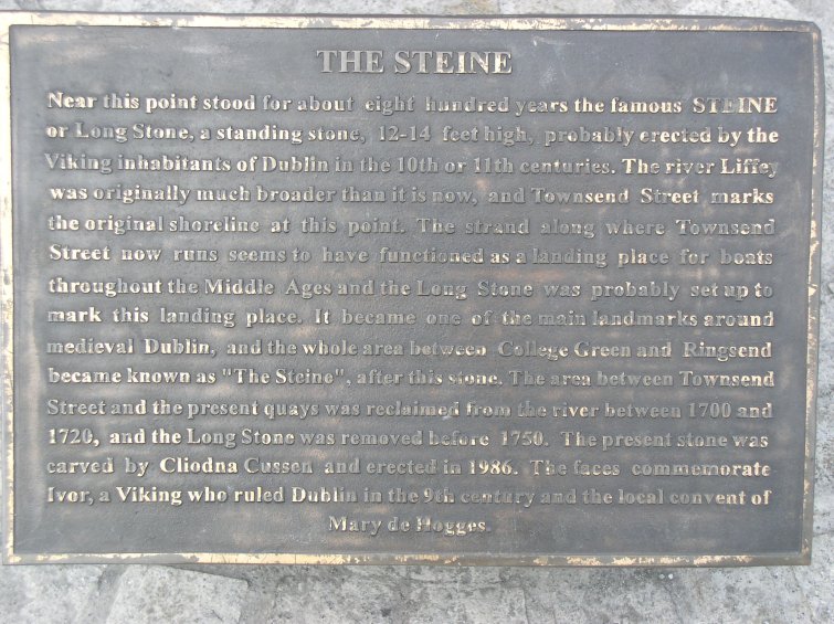
The oldest Anglo-Norman records in Ireland frequently refer to an extra mural district, east of Dublin, denominated "The Stein" or "Steine", a flat piece of land extending southwards from the strand of the Liffey to "the lands of the Rath", and eastward from near the city walls to the river Dodder.
 Previous to 1607, the whole
north side of Townsend Street, now covered with streets and quays, was the tidal
strand of the Liffey, and as such, was granted to Sir William Carroll under the
description of "the strand overflown by the sea between the point of land
adjoining the Staine, near the College (Trinity College) and
Ringsend". And by him, this strand was partly reclaimed. Another portion
was taken in 1663 when Hawkins built his great wall, carrying the shore further
toward the river. The embankments raised by Sir William Carroll, Hawkins and Sir
John Rogerson, together with subsequent encroachments on the strand of the river
have so greatly altered the outline of the Stein on the north side, that without
any maps or surveys of the area having been taken, it is impossible to now
identify the outline of the lands previous to the 17th century. However, there
was known to be an elevated ridge near the confluence of the rivers Liffey and
Dodder and was the place where the Dublin vikings generally landed. This point
of the Stein continued to be long used as a landing and embarking point for
travelers and trade as mentioned in the Memoranda Rolls of Henry IV mentioning
"the Stayne and Dodyr" with "the key of Dublin" as places from where merchandise
was exported.
Previous to 1607, the whole
north side of Townsend Street, now covered with streets and quays, was the tidal
strand of the Liffey, and as such, was granted to Sir William Carroll under the
description of "the strand overflown by the sea between the point of land
adjoining the Staine, near the College (Trinity College) and
Ringsend". And by him, this strand was partly reclaimed. Another portion
was taken in 1663 when Hawkins built his great wall, carrying the shore further
toward the river. The embankments raised by Sir William Carroll, Hawkins and Sir
John Rogerson, together with subsequent encroachments on the strand of the river
have so greatly altered the outline of the Stein on the north side, that without
any maps or surveys of the area having been taken, it is impossible to now
identify the outline of the lands previous to the 17th century. However, there
was known to be an elevated ridge near the confluence of the rivers Liffey and
Dodder and was the place where the Dublin vikings generally landed. This point
of the Stein continued to be long used as a landing and embarking point for
travelers and trade as mentioned in the Memoranda Rolls of Henry IV mentioning
"the Stayne and Dodyr" with "the key of Dublin" as places from where merchandise
was exported.
But the vikings would have had a particular reason for selecting this as their landing place. Their ships were long and shallow draft vessels, lightly built and often with little or no deck area. Their ships were beached when they landed and during winter, were drawn ashore until the fairer winds and seas of late spring. The banks of a river, especially a flat sandy strand such as the north side of the Stein presented, was an ideal landing area for their ships.
 On the west side of this landing was a
creek, this was the river of the Stein and on it was built the mill of the
Priory of All Hallows. The mill is referred to in a grant made in 1298 of
"four large oaks from the king's forest of Glencree to repair his mill and
bridge of Stein" In a separate grant made to rebuild the mill in 1461,
mention is made of "a mill near the gate between Green bank and the long
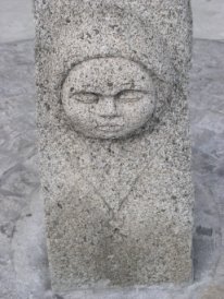
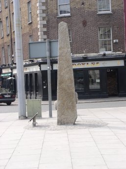
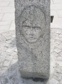
stone on the Stayne..." It was from the "Long Stone", mentioned in this
record, that the Stein derived its Scandinavian name. This remarkable pillar
stone is believed to have stood not far from the landing place near where the
present Hawkins and Townsend Streets now meet (as outlined in Petty's Down
Survey of the Half Barony of Rathdown, 1655). Charles Haliday claims to have
possessed a rough outline drawing and stated that it did not appear to have been
inscribed in any way and stood about twelve or fourteen feet above the ground.
It remained standing until the surrounding district was laid out for streets and
houses when it was overturned to make room for them. Numerous other references
were made about the stone; a lease made by the City in 1607 to James Wheeler,
Dean of Christ Church, of a "void ground at the Long Stone of the
Stein", another in 1641 to William Kirtly of a "small plot near the
Long Stone of the Stein", again in 1679 to William Christian of ground at
Lazers Hill "near the Long Stone of the Stein" and finally from the
Earl of Anglesey of "a parcel of the strand at the Long Stone of the Stein
over against the College". The final use, destruction or location of the
long stone is not recorded, however, in the 1970's a replica was erected near to
the original location.
On the west side of this landing was a
creek, this was the river of the Stein and on it was built the mill of the
Priory of All Hallows. The mill is referred to in a grant made in 1298 of
"four large oaks from the king's forest of Glencree to repair his mill and
bridge of Stein" In a separate grant made to rebuild the mill in 1461,
mention is made of "a mill near the gate between Green bank and the long
stone on the Stayne..." It was from the "Long Stone", mentioned in this
record, that the Stein derived its Scandinavian name. This remarkable pillar
stone is believed to have stood not far from the landing place near where the
present Hawkins and Townsend Streets now meet (as outlined in Petty's Down
Survey of the Half Barony of Rathdown, 1655). Charles Haliday claims to have
possessed a rough outline drawing and stated that it did not appear to have been
inscribed in any way and stood about twelve or fourteen feet above the ground.
It remained standing until the surrounding district was laid out for streets and
houses when it was overturned to make room for them. Numerous other references
were made about the stone; a lease made by the City in 1607 to James Wheeler,
Dean of Christ Church, of a "void ground at the Long Stone of the
Stein", another in 1641 to William Kirtly of a "small plot near the
Long Stone of the Stein", again in 1679 to William Christian of ground at
Lazers Hill "near the Long Stone of the Stein" and finally from the
Earl of Anglesey of "a parcel of the strand at the Long Stone of the Stein
over against the College". The final use, destruction or location of the
long stone is not recorded, however, in the 1970's a replica was erected near to
the original location.
 The function of the long stone is not entirely
clear. It may have been a memory stone, a mark of possession taken by the first
settlers and perhaps raised to Thor or Freyja as was done in the Shetland and
Orkney Islands. Olaus Magnus in his work, Compendious History of the Goths,
Swedes and Vandals, mentions another purpose, he believes there are high
stones, without inscriptions, set up to inform mariners that they may avoid
shipwreck, and we find that the custom of placing pillar stones at the landing
place was not peculiar to the vikings, it was also done in Kent at "Lapis
tituli" or Folkstone, the landing place of the Saxons. Near the stone pillar at
Steinness in the Orkney Islands, mounds were also found in which were found nine
silver fibulae. Also located nearby in Steiness was another artificial mound of
two feet in diameter and thirty six feet high, of a conical outline, occupying
the centre of a raised circular platform, which formed a terrace around it. This
was the Thingmount and within view was a circle of upright stones alleged to
have been a temple dedicated to Thor, and a semicircle of similar stones, which
was said to have been either a temple to Freyja or the moon. (Description of
the Isles of Orkney, Rev. James Wallace, Edinburgh, 1693). A similar
situation existed in Dublin with the Thingmount in close proximity to the long
stone, the landing place and as we see below, mounds were also in evidence.
The function of the long stone is not entirely
clear. It may have been a memory stone, a mark of possession taken by the first
settlers and perhaps raised to Thor or Freyja as was done in the Shetland and
Orkney Islands. Olaus Magnus in his work, Compendious History of the Goths,
Swedes and Vandals, mentions another purpose, he believes there are high
stones, without inscriptions, set up to inform mariners that they may avoid
shipwreck, and we find that the custom of placing pillar stones at the landing
place was not peculiar to the vikings, it was also done in Kent at "Lapis
tituli" or Folkstone, the landing place of the Saxons. Near the stone pillar at
Steinness in the Orkney Islands, mounds were also found in which were found nine
silver fibulae. Also located nearby in Steiness was another artificial mound of
two feet in diameter and thirty six feet high, of a conical outline, occupying
the centre of a raised circular platform, which formed a terrace around it. This
was the Thingmount and within view was a circle of upright stones alleged to
have been a temple dedicated to Thor, and a semicircle of similar stones, which
was said to have been either a temple to Freyja or the moon. (Description of
the Isles of Orkney, Rev. James Wallace, Edinburgh, 1693). A similar
situation existed in Dublin with the Thingmount in close proximity to the long
stone, the landing place and as we see below, mounds were also in evidence.
The name of "the Stein" is not found in Irish manuscripts or any record earlier than the Anglo Norman invasion of Ireland. In fact the Irish knew it a "the Green of Ath Cliath" and alluded to it as a place where Brian Boru held council with the nobles of the Dal Cais (Wars of the Gaedhil with the Gaill, Rev Dr Todd, 1867). While the Anglo Norman monks rarely, if ever, used an Irish name when any other existed, and invariably called the city and even the provinces by their Scandinavian names.
There are other significant monuments related to the Stein of Dublin. In 1646, an attempt was made to fortify Dublin by earthworks. To obtain this earth, they leveled one of the tumuli on the Stein and an account of this was written in Ware's Antiquities:
"In November 1646, as people were employed in removing a little hill in the East Suburbs of Dublin, in order to form a line of fortification, there was discovered an ancient sepulchre, placed S.W. and N.E., composed of eight black marble stones, of which two made the covering, and was supported by the others. The length of this monument was six feet two inches and the breadth three feet one inch, and the thickness of the stone three inches. At each corner of it was erected a stone, four feet high and near it at the SW end, another stone was placed in the form of a pyramid, six feet high, of a rustic work and of that kind of stone which is called a millstone. The engraving given is a draught of the monument taken before it was demolished. Vast quantities of burnt coals, ashes, and human bones, some of which were in part burned, and some only scorched were found in it, which was looked upon to be a work of the Ostmen (Ostmen, East men, i.e. vikings), and erected by that people while they were heathens, in memory of some petty prince or nobleman". (Works of Sir James Ware, by Walter Harris, vol ii, Dublin, 1745).
This description is closely related to the description of other viking burial sites and Charles Haliday even went so far as to put forth the argument that this grave mound was attributed to Ivar, son of Regner Lodbrok, who reigned and died in Dublin in 872 and who, it is recorded, had ordered his body to be buried at the landing place. But, regardless of identity, it may be observed that burying their dead near the landing place was a custom that prevailed among the vikings and a greater number of their mounds have been found on the sea shore or in places commanding a view of the open sea and several Danish or Norwegian kings were slain in or around Dublin, to whom mounds were doubtless raised.
 Indeed, several excavations in
Dublin have unearthed finds that point to evidence of the burial of viking
chieftains or kings. In Suffolk Street, formerly part of the Staine, a skeleton
was exhumed, the skull of which was stained by direct contact with metal, most
probably from a helmet, this person was therefore most likely buried in their
armor. In the same locality, an urn was also found as well as one of the most
valuable viking swords discovered in Ireland, including a gold ornamented
handle. According to the Saga's, a gold hilted sword was a distinguishing mark
of a Scandinavian chieftain or king ("Kvernlstr" the sword of Hakon, king of
Norway, had both hilt and handle of gold and "Heitn", the sword of King Olaf the
Saint, had the handle wrought of gold). Various other weapons have been
unearthed during building works in and around this area also.
Indeed, several excavations in
Dublin have unearthed finds that point to evidence of the burial of viking
chieftains or kings. In Suffolk Street, formerly part of the Staine, a skeleton
was exhumed, the skull of which was stained by direct contact with metal, most
probably from a helmet, this person was therefore most likely buried in their
armor. In the same locality, an urn was also found as well as one of the most
valuable viking swords discovered in Ireland, including a gold ornamented
handle. According to the Saga's, a gold hilted sword was a distinguishing mark
of a Scandinavian chieftain or king ("Kvernlstr" the sword of Hakon, king of
Norway, had both hilt and handle of gold and "Heitn", the sword of King Olaf the
Saint, had the handle wrought of gold). Various other weapons have been
unearthed during building works in and around this area also.
From the description of the Stein, including burial mounds, a long stone and the close proximity of a Thingmount, it can be seen that viking age Dublin was an extremely important and significant part of the viking world and the worship of the Aesir, Vanir and landvettir would have been carried out with the same fervor and passion as it was elsewhere in the heathen world.
This article is © 2004 to Askeladden and may not be reposted in any format without the consent of the author.
Click here to return to the main page