

Zuid Afrikaansche Republiek (First
Republic)
Klerksdorp / Potchefstroom / Andries-Ohrigstad / Zoutpansberg / Lydenburg
It was not until 13 February 1858 that the Trekkers north of the Vaal (recognised as an independent state in 1852) adopted a proposal for state symbols. The decision of that date was taken by the Committee Raad, and proposed to the Volksraad that it adopt a flag and a rudimentary coat of arms.
These were formally adopted on the 18th by the Volksraad.
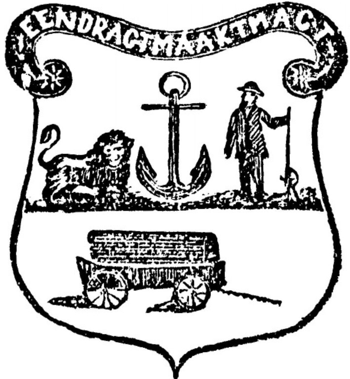
The arms were loosely described, and Brownell[1] translates the wording as follows:
On a silver field there shall be placed a Wagon and a Golden Anchor, while an Eagle shall rest upon the Arms. On the right-hand side of the Arms a Man in national costume, armed with a gun and accessories. On the left-hand side a Lion.
Brownell writes: “The ambiguous description of the arms left ample room for various interpretations – and there were to be a wide variety of interpretations over the ensuing years.”
The terms left and right are used in their usual non-heraldic meanings, so that the Boer warrior is on the sinister and the lion on the dexter (see What is left and right in a coat of arms?).
The lion, following Continental European practice, lies toward the centre of the coat of arms, and so is technically contourné. In the 1867 illustration it is facing the viewer, or gardant, but later it was to face the centre of the shield.
The flag was the first appearance of what came to be known as the Transvaal Vierkleur (three horizontal panels of red, white and blue, with a vertical green panel in the hoist), although it was not identical to that flag, since it incorporated an inscription, Eendragt Maakt Magt, on the green panel.
A curious detail is also that no subsequent legislation of the ZAR ever formally defined either the arms or the flag, so although the Vierkleur was to remain (with two interruptions) the symbol of the state until 1902, and was usually to be seen without any inscription, the wording in fact legally formed part of it.
The flag was first hoisted at Potchefstroom.
The motto Eendragt Maakt Magt, although it was legally defined as being part of the flag, became instead attached to the arms. It is derived from the motto of the Dutch Republic. Brownell notes: “There is no indication that the motto ever appeared on the flag, and it instead found a more appropriate place as an adjunct to the arms.”
The illustration that appears above first appeared on 19 July 1867 – curiously omitting the eagle.
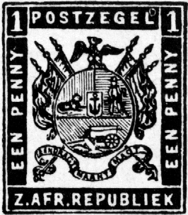
Brownell also notes: “. . . in the earliest representations of the arms they were depicted with a shield and motto only while – following no doubt the example of the Orange Free State – flags appeared draped on either side of the shield from 1869 on the ZAR’s first postage stamps, and from 20 February 1872 on the arms which appeared on the Staats Courant. An eagle ensigning the arms, as provided for in the Volksraad resolution, made its appearance at the same time that the flags were added on either side of the shield. The anchor was now also placed on an inescutcheon.”
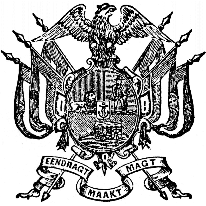
About the eagle he remarks: “Until the late 1890s, and on all the Great Seals of the Republic, the eagle was consistently represented as facing to sinister, contrary to normal heraldic practice.”
The lion appears lying or couchant in a position regarded as normal in Continental European armory, contourné or turned around to face the middle of the shield. (In British practice it would face the dexter, but the devisers of this emblem in any case had no concept of heraldic positioning.) In the 1867 drawing it is gardant or facing the viewer, but in later drawings it faces the line of partition.
The arms had now acquired what can be regarded as their definitive form – incorporating, instead of a regular shield outline, a cartouche, more properly used for the arms of women and of clerics.
And of the last president of the First Republic: “President T F Burgers, who was not satisfied with the arms or flag, had an amendment to the arms approved by the Volksraad in October 1874, while a new flag based on the ‘Voortrekker flag’, but with the red saltire fimbriated white, was also approved in place of the ‘Vierkleur’. The ink was hardly dry on this change when the Volksraad reversed its decision during May 1875, while the President was overseas, and reverted to the original arms and flag. The new saltire flag was, however, retained as the presidential flag, but soon fell into abeyance, for some felt that it too closely resembled the Union Jack.”
The Great Trek:
While the Great Trek, the movement during the late 1830s of Boer farmers out of the eastern districts of the Cape Colony, largely took place in Transorangia (the later Oranje Vrij Staat) and Natal, several parties of Trekkers also established themselves north of the Vaal River.
The trek parties largely followed routes reconnoitred by commission trekkers, only one of whom, J Scholtz, crossed the Vaal River. The Trek parties of Hans van Rensburg and Louis Trichardt both ventured far north, the Van Rensburg trekkers disastrously so, being cut down by indigenous peoples and disease after they had crossed the Limpopo River.
Trichardt trekked as far north as the Zoutpansberg before succumbing to disease and attacks by indigenous tribes. The remnants of the trek party gathered in Delagoa Bay before taking ship to Port Natal.
In 1836 Andries Hendrik Potgieter reached northern Transorangia and, by barter agreement with the Taung chief Makwana, acquired the territory between the Vet and Vaal rivers. In August that year, while Potgieter himself was reconnoitring the Zoutpansberg, amaNdebele[2] under command of Mzilikazi attacked the advance guard of his party in the Vet-Vaal region. In October, at the Battle of Vechtkop, the Ndebele were repulsed, but made off with all the Trekkers’ livestock. With cattle loaned to them by Moroka they recovered.
Potgieter then led punitive raids against the Ndebele in January and November of 1837. In the November raid, the Ndebele military kraal at Mosega was destroyed, and Mzilikazi and his army separated from the old men, women and children of his tribe. This second group made its way to the vicinity of Bulawayo, in what is now Zimbabwe, only to be joined there three years later by Mzilikazi and his army.
The region now being free of Mzilikazi’s aggression – and large areas of it having been cleared by him of their previous population – Trekkers moved north of the Vaal.
Claimed to be the oldest town in the Transvaal region is Klerksdorp, in the west, where 12 Trekker families settled on the banks of the Schoonspruit in 1837. The settlement was named after the first landdrost, Jacob de Clercq. Under the name Klerksdorp, it is first recorded in 1853, a year later than Potchefstroom.
The principal town in the west was founded in November 1838 by Hendrik Potgieter. The town, on the banks of the Mooi River, was initially called Mooriviersdorp, then Potchefspruit, and in 1852 Andries Pretorius named it Vryburg. But the name eventually used for the place (first recorded in 1840) was Potchefstroom.[3]
While based at Potchefstroom, Potgieter was also Commandant-General of the Republiek Natalia.
It was at Potchefstroom that the Thirty-three Articles, the first constitution for the state north of the Vaal, was drawn up, incorporating descriptions of the coat of arms and the flag of the republic (as described above).
In June 1845, following the annexation of Natal by the British, Potgieter moved from Potchefstroom and settled at Andries-Ohrigstad,[4] believing it to be beyond the reach of the Cape of Good Hope Punishment Act, which defined the reach of British influence in Africa as extending northwards to 25ºS, and intending to establish trade links with the outside world through Delagoa Bay. Other Trekkers from Natal joined him there.
However the settlement at Andries-Ohrigstad was doomed, since malaria killed many of the residents in the summer of 1848-49. During 1848 Potgieter moved north, settling at the foot of the Zoutpansberg range and establishing a village which he called Zoutpansbergdorp,[5] while several of his followers moved further south-westward to Lydenburg.
Following his death in 1852, his son Piet Potgieter assumed the title commandant-general, which then passed following his death in 1854 to Stephanus Schoeman, who four years later named the village after himself. Evacuated on 15 July 1867 because of war with the vaVenda, the town was destroyed by fire the same night, and was not rebuilt.[6] It is today a historical monument.
An offshoot of Ohrigstad was the settlement initially planned 48 km south-west of that settlement in 1849, but since it lacked water this site was also abandoned, and in 1850 the town was established on the farm Rietspruit, at the confluence of the Spekboom River[7] and the Sterkspruit. Named Lydenburg,[8] it became the leading town in the eastern Transvaal region.
Andries Pretorius, after his unsuccessful attempt to discuss the emigrants’ grievances with Cape Governor Sir Henry Pottinger at Grahamstown, crossed the Vaal in 1848 and settled near the Magaliesberg.
Through Pretorius’s efforts the leaders of the various Trek parties met at Derdepoort in 1849 and formed the Vereenigde Band (united bond) which was the first attempt at forming a national government for the Transvaal region.
In the far south-east, a group of Trekkers settled along the Buffalo River in 1852 in what is now the northern part of KwaZulu-Natal, but which then lay beyond the limits of the Colony of Natal. Andries Pretorius disapproved of their action, since the area fell outside the proclaimed boundaries of the “Transvaal” republic and might be considered an encroachment on British territory, so endangering the existence of that state.
The community (styling themselves the Buffels Rivier-maatschappij) in 1854 gave the Zulu king Mpande 100 head of cattle in exchange for the land they occupied. They elected Commandant A T Spies as landdrost and four heemraden, and approached the ZAR in the hope of incorporation. In 1855 the ZAR acknowledged J C Steyn as landdrost and J C Klopper as commandant, but this effectively created two separate authorities in the territory.
In February 1856 the Spies faction, which favoured Lydenburg (at this stage separated from Potchefstroom), approached the Volksraad there regarding incorporation. In March a town was laid out along a tributary of the Buffalo (now called the Dorpsrivier) and named Utrecht.[9] In 1858 the Lydenburg republic incorporated Utrecht.
About the republic:
In 1852 Sir Harry Smith, Governor of the Cape and High Commissioner for South Africa, decided to wash his hands of responsibility for the furthest of the Voortrekker parties.
Meeting on the banks of the Sand River, south of the Vaal, with Trekker representatives, Sir Harry on 17 January that year signed the Sand River Convention, “which guaranteed the Transvaalers freedom to manage their own affairs without let or hindrance from H M Government”.[10]
This came a full two years before the Bloemfontein Convention, giving the same guarantee to the Boers (here both Trekkers and Trekboere)[11] occupying the Orange River Sovereignty, which then became the Oranje Vrij Staat.
Both states were technically under British suzerainty, but in practice they were left to their own devices.
A N Pelzer, writing in SESA, notes: “In 1857, through Andries Pretorius’s son, Marthinus Wessel, a constitution was agreed upon for the new state, which was to be known officially as Zuid Afrikaansche Republiek, and provision was made for a legislature, the Volksraad, with a president and an executive council.
“Even then unity was not at once or easily attained. Zoutpansberg . . . disliked the appointment of M W Pretorius as president, and withdrew from the Republic. Lydenburg, where religious dissension affected politics, also seceded and formed a republic of its own. These defections, however, did not last long. In Feb. 1858 Schoeman and Pretorius were reconciled and the constitution was again ratified, with Pretorius as president and Schoeman as commandant-general.
“In 1860 not only Lydenburg but also Utrecht . . . agreed to incorporation.”
In 1858 Section 17 of the Constitution was amended to read: “Potchefstroom shall be the capital of the Republic and Pretoria the seat of government.” Pretoria, at that stage having little more than a landdrost who was arranging the sale of plots on the site of the town, was nonetheless acceptable to all parties since it had not been the base of any of the Trek parties, and in time superseded Potchefstroom.
Pelzer writes further: “M W Pretorius . . . was eager to unify the Transvaal and the Orange Free State and, after two unsucessful attempts in1856 and 1858, he was elected president also of the Orange Free State in 1859. This led to a great deal of confusion, and he had to resign as president of the Transvaal. During his absence civil disturbances occurred between 1860 and 1864. Peace was restored in the latter year, when Pretorius was again elected president of the Transvaal and ceased to occupy that position in the OFS, while Paul Kruger became commandant-general of the Transvaal. Pretorius was re-elected in 1869.”
A boundary dispute between the ZAR and OVS in 1870 led to a decision in the ZAR’s favour by the Lieutenant-Governor of Natal, R W Keate. But when Keate again arbitrated, this time on the question of the diamond fields (the Kimberley dispute) in 1871, both Boer republics lost their claims. The result was that Pretorius was strongly attacked in the Volksraad, and resigned. The constitution being altered to allow a foreigner to be elected, the choice fell on Thomas François Burgers, a dominee of the NG Kerk then stationed at Hanover in the Cape Colony.
Burgers was, Pelzer writes, “a man of enlightened ideas and soon lost touch with a number of the burghers”.
Keen on the construction of a railway into the republic from Delagoa Bay, he travelled to Europe and concluded a treaty of trade and friendship with Portugal.
On his return, he was obliged to wage war against the Pedi chief Sekhukhune, at a time when the ZAR was short of money. However, it was not simply lack of money that bedevilled the Sekhukhune campaign. Both Kruger and Piet Joubert declined to lead the expedition, and Burgers was obliged to take the field as commander-in-chief, with M W Pretorius and Nicolaas Smit as generals. Many of the conservative burghers regarded Burgers as a heretic, and refused to fight under him, preferring to return home.
Pelzer writes: “Although Sekhukhune made overtures for peace, he was not defeated and this fact, together with the shaky financial position, gave Sir Theophilus Shepstone the pretext he required to annex the Transvaal Republic as a British colony on 12 April 1877.”
The republic now became known as the Transvaal.
