 GEOGRAPHY
The Gorean Map
The Gorean Compass
The Stars
Goreans and Nature
MAIN LANDS
Polar Bassin
Torvaldsland
The Northern Forests
The Vosk Delta
The Barrens
Turian Plains
Tahari
The Rain Forest
Equatorial Marshes
The Swamp Forest of Ar
The Woods of Clearchus

The Gorean Map
"I regarded the vast map on the floor of the chamber. I could see, high on the map, Ax Glacier, Torvaldsland, and Hunjer and Skjern, and Helmutsport, and lower, Kassau and the great green forests, and the river Laurius, and Laura and Lydius, and lower, the islands, prominent among them Cos and Tyros; I saw the delta of Vosk, and Port Kar, and, inland, Ko-ro-ba, the Towers of the Morning, and Thentis, in the mountains of Thentis, famed for her tarn flocks; and, to the south, among many other cities, Tharna, of the vast silver mines; I saw the Voltai Range, and Glorious Ar, and the Cartius, and, far to the south, Turia, and near the shore of Thassa, the islands of Anango and Ianda, and on the coast, the free ports of Schendi and Bazi. There were, on the map, hundreds of cities, and promontories and peninsulas, and rivers and inland lakes and seas."
"Tribesmen of Gor" page 1
"Much of Gor was terra incognita. Few knew well the lands on the east of the Voltai and Thentis ranges, for example, or what lay west of the farther islands, near Cos and Tyros. It was more irritating, of course, to realize that even considerable areas of territory above Schendi, south of the Vosk, and west of Ar, were unknown."
"Explorers of Gor" page 16
The Gorean Compass
"For purposes of convenience I am recounting directions in English terms, thinking it would be considerably difficult for the reader to follow references to the Gorean compass. Briefly, for those it might interest, all directions on the planet are calculated from the Sardar Mountains, which for the purposes of calculating direction play a role analogous to our north pole; the two main directions, so to speak, in the Gorean way of thinking are Ta-Sardar-Var and Ta-Sardar-Ki-Var, or as one would normally say, Var and Ki-Var; 'Var' means a turning and 'Ki' signifies negation; thus, rather literally, one might speak of 'turning to the Sardar' and 'not turning to the Sardar', something like either facing north or not facing north; on the other hand, more helpfully, the Gorean compass is divided into eight, as opposed to our four, main quadrants, or better said, divisions, and each of these itself is of course subdivided. There is also a system of latitude and longitude figured on the basis of the Gorean day, calculated in Ahn, twenty of which constitute a Gorean day, and Ehn and Ihn, which are subdivisions of the Ahn, or Gorean hour. Ta-Sardar-Var is a direction which appears on all Gorean maps; Ta-Sardar-Ki-Var, of course, never appears on a map, since it would be any direction which is not Ta-Sardar-Var. Accordingly, the main divisions of the map are Ta-Sardar-Var, and the other seven; taking the Sardar as our "north pole" the other directions, clockwise as Earth clocks move (Gorean clock hands move in the opposite direction) would be, first, Ta-Sardar-Var, then, in order, Ror, Rim, Tun, Vask (sometimes spoken of as Verus Var. or the true turning away), Cart, Klim, and Kail, and then again, of course, Ta-Sardar-Var."
"Nomads of Gor" page 3
The Stars
"Oddly enough, one of the expressions in the tongue of Gor for our sun was Lar-Torvis, which means The Central Fire, another Pythagorean expression, except that it had not been, as I understand it, originally used by the Pythagoreans to refer to the sun but to another body. The more common expression for the sun was Tor-tu-Gor, which means Light Upon the Home Stone."
"Tarnsman of Gor" page 28
"�Not unlike Tor-tu-Gor, or Sol,� I said, �the common star of Earth and Gor.�"
"Beasts of Gor" page 372
"Sometimes I guided my tarn by the stars, the same fixed stars I had seen from another angle above my head in the mountains of New Hampshire."
"Tarnsman of Gor" page 74
"I looked up and saw the three moons of Gor, the large moon and the two small ones, one of the latter called the Prison Moon, for no reason I understood."
"Assassin of Gor" page 170
Goreans and Nature
"Goreans care for their world. They love the sky, the plains, the sea, the rain in the summer, the snow in the winter. They will sometimes stand and watch clouds. The movement of grass in the wind is very beautiful to them.
More than one Gorean poet has sung of the leaf of a Tur tree. I have known warriors who cared for the beauty of small flowers."
"Hunters of Gor" page 119
"I personally would not care to be the man responsible for the destruction of a Gorean forest. It is not unknown for them to be hunted down and burned alive, their ashes scattered in expiation by mourning Goreans among the charred wood and blackened stumps. Sometimes it takes, according to the Goreans, a generation for the forest to forgive its injury, and return to men, gracious and forgiving, in all its beauty."
"Hunters of Gor" page 119
"The Goreans, often so cruel to one another, tend to have an affection for wildlife and growing things, which they regard as free, and thereby deserving of great respect."
"Captive of Gor" page
GEOGRAPHY
"I shrugged. Much of Gor was terra incognita. Few knew well the lands on the east of the Voltai and Thentis ranges, for example, or what lay west of the farther islands, near Cos and Tyros. It was more irritating, of course, to realize that even considerable areas of territory above Schendi, south of the Vosk, and west of Ar, were unknown."
"Explorers of Gor" page 16
"I could see, high on the map, Ax Glacier, Torvaldsland, and Hunjer and Skjern, and Helmutsport, and, lower, Kassau and the great green forests, and the river Laurius, and Laura and Lydius, and, lower, the islands, prominent among them Cos and Tyros; I saw the delta of the Vosk, and Port Kar, and, inland, Ko-ro-ba, the Towers of the Morning, and Thentis, in the mountains of Thentis, famed for her tarn flocks; and, to the south, among many other cities, Tharna, of the vast silver mines; I saw the Voltai Range, and Glorious Ar, and the Cartius, and, far to the south, Turia, and near the shore of Thassa, the islands of Anango and Ianda, and on the coast, the free ports of Schendi and Bazi. There were, on this map, hundreds of cities, and promontories and peninsulas, and rivers and inland lakes and seas."
"Tribesmen of Gor" page 7
MAIN LANDS
Polar Bassin
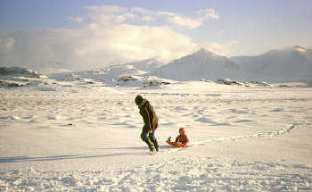
"Many people do not understand the nature of the polar north. For one thing, it is very dry. Less snow falls there generally than falls in lower latitudes. Snow that does fall, of course, is less likely to melt. Most of the land is tundra, a coo, generally level or slightly wavy, treeless plain. In the summer this tundra, covered with mosses, shrubs and lichens, because of the melted surface ice and the permafrost beneath, preventing complete drainage, is soft and spongy. In the winter, of course, and in the early spring and late fall, desolate, bleak and frozen, wind-swept, it presents the aspect of a barren alien landscape. At such times the red hunters will dwell by the sea, in the spring and fall by its shores, and, in the winter, going out on the ice itself."
"Beasts of Gor" page 196
"Ax Glacier was far to the north, a glacier spilling between two mountains of stone, taking in its path to the sea, spreading, the form of an ax. The men of the country of Ax Glacier fish for whales and hunt snow sleen. They cannot farm that far to the north."
"Marauders of Gor" page 139
~ TORVALDSLAND ~
"Torvaldsland is a cruel, harsh, rocky land. It contains many cliffs, inlets and mountains. Its arable soil is thin, and found in patches. The size of the average farm is very small. Good soil is rare and highly prized. Communication between farms is often by sea, in small boats. Without the stream of Torvald, it would probably be impossible to raise cereal crops in sufficient quantity to feed even its relatively sparse population... The stream of Torvald is regarded by the men of Torvaldsland as a gift of Thor, bestowed upon Torvald, the legendary founder and hero of the land, in exchange for a ring of gold."
"Marauders of Gor" page 55/6
"I had heard of this stone. It is taken by many to mark the border between Torvaldsland and the south. Many of those of Torvaldsland, however take its borders to be much farther extended than the Torvaldsmark. Indeed, some of the men of Torvaldsland regard Torvaldsland to be wherever their ships beach, as they took their country, and their steel, with them."
"Marauders of Gor" page 45
~ NORTHERN FORESTS ~

"The northern forests, the haunts of bandits and unusual beasts, far to the north and east of Ko-ro-ba, my city, are magnificent, deep forests, covering hundreds of thousands of square pasangs. Slave girls who escape masters or some free women, who will not accept the matches arranged by their parents, or reject the culture of Gor, occasionally flee to these forests and live together in bands, building shelters, hunting their food, and hating men; there are occasional clashes between these bands of women, who are often skilled archers, and bands of male outlaws inhabiting the same forests; hardy Slavers sometimes go into the forests hunting these girls, but often they do not return; sometimes Slavers simply meet outlaws at the edges of the forests, at designated locations, and buy captured girls from them; interestingly, at other locations, on the eastern edges of the forests, Slavers from Port Kar meet the female groups and purchase men they have captured; it is not too uncommon that a Slaver Warrior has entered the forest only to be captured by his prey, enslaved, and eventually, when the girls tire of him, be sold, commonly for arrow points and adornments, to Port Kar Slavers, whence he will find himself chained to the oar of a cargo galley."
"Assassin of Gor" page 293/4
""Then, after perhaps another hour, we came, almost abruptly, suddenly, to a stand of the high trees, the Tur trees, of the northern forests.
It was breathtakingly beautiful.
The girls stopped.
I looked about myself. The forests of the northern temperate latitudes of Gor are countries in themselves, covering hundreds of thousands of square pasangs of area. They contain great numbers of various species of trees, and different portions of the forests may differ considerably among themselves. The most typical and famous tree of these forests is the lofty, reddish Tur tree, some varieties of which grow more than two hundred feet high. It is not known how far these forests extend. It is not impossible that they belt the land surfaces of the planet. They begin near the shores of Thassa, the Sea, in the west. How far they extend to the east is not known. They do extend beyond the most northern ridges of the Thentis Mountains.
We found ourselves now in a stand of the lofty Tur trees. I could see broadly spreading branches some two hundred feet or more above my head. The trunks of the trees were almost bare of branches until, so far above, branches seemed to explode in an interlacing blanket of foliage, almost obliterating the sky. I could see glimpses of the three moons high above. The floor of the forest was almost bare. Between the lofty, widely spaced trees there was little but a carpeting of leaves."
"Captive of Gor" page 129
"We were fifty pasangs north of Lydius, which port lies at the mouth of the Laurius River. Far above the beach we could see the green margins of the great northern forests.
They were very beautiful."
"Hunters of Gor" Page 18
"Yet on the trackless beaches, lining the western edge of the great northern forests for hundreds of pasangs, below the bleakness of Torvaldsland, it would not be easy to make rendezvous."
"Hunters of Gor" Page 243
~ THE VOSK DELTA ~

"On river barges, for hundreds of pasangs, I had made my way down the Vosk, but where the mighty Vosk began to break apart and spread into its hundreds of shallow, constantly shifting channels, becoming lost in the vast tidal marshes of its delta, moving toward gleaming Thassa, the Sea, I had abandoned the barges, purchasing from rence growers on the eastern periphery of the delta supplies and the small rush craft which I now propelled through the rushes and sedge, the wild rence plants."
"Raiders of Gor" page 5
"Never has a slave girl escaped from canaled Port Kar, protected on one side by the interminable, rush-grown delta of the Vosk, on the other by the broad tides of the Tamber Gulf, and beyond it, the vast, blue, gleaming, perilous Thassa."
"Assassin of Gor" page 305
~ THE BARRENS ~
I considered the Barrens. They are not, truly, as barren as the name would
suggest. They are barren only in contrast, say, with the northern forests or
the lush land in river valleys, or the peasant fields or meadows of the
southern rain belts. They are, in fact, substantially, vast tracts of rolling
grasslands, lying east of the Thentis Mountains. I have suspected that
they are spoken of as the Barrens not so much in an attempt to appraise
them with geographical accuracy as to discourage their penetration, exploration
and settlement. The name, then, is perhaps not best regarded as an item of
purely scientific nomenclature but rather as something else, perhaps a warning.
Also, calling the area the Barrens gives men a good excuse, if they should
desire such, for not entering upon them. To be sure, the expression 'Barrens'
is not altogether a misnomer. They would be, on the whole, much less arable than much of the other land of known Gor. Their climate is significantly influenced by the Thentis Mountains and the absence of large bodies of water. Prevailing winds in the northern hemisphere of Gor are from the north and West. Accordingly a significant percentage of moisture-laden air borne by westerly winds is forced by the Thentis Mountains to cooler, less-heated air strata, where it precipitates, substantially on the eastern slopes of the mountains and the fringes of the Barrens. Similarly the absence of large bodies of water in the Barrens reduces rainfall which might be connected with large-scale evaporation and subsequent precipitation of this moisture over land areas, the moisture being carried inland on what are, in effect, sea breezes, flowing into low pressure areas caused by the warmer land surfaces, a given amount of radiant energy raising the temperature of soil or rock significantly more than it would raise the temperature of an equivalent extent of water.
The absence of large bodies of water adjacent to or within the Barrens also has
another significant effect on their climate. It precludes the Barrens from
experiencing the moderating effects of such bodies of water on atmospheric
temperatures. Areas in the vicinity of large bodies of water, because of the
differential heating ratios of land and water usually have warmer winters and
cooler summers than areas, which are not so situated. The Barrens, accordingly, tend to be afflicted with great extremes of temperature, often experiencing bitterly cold winters and long, hot, dry summers.
"Another possibility," Samos was saying, "would be a loan to the Sa-Tarna merchants, at a reduced rate of interest. Thus we might avoid the precedent of a direct subsidy to a sub caste. To be sure, we might then encounter resistance from the Street of Coins. Tax credits would be another possible incentive."
At the edge of the Thentis Mountains, in the driest areas, the grass is short. As one moves in an easterly direction it becomes taller, ranging generally from ten to eighteen inches in height; as one moves even further east it can attain a height of several feet, reaching as high as the knees of a man riding a kaiila. On foot, it is easier to become lost in such grass than in the northern forests. No white man, incidentally, at least as far as I know, has ever penetrated to the eastern edge of the Barrens. Certainly, as far as I know, none has ever returned from that area. Their extent, accordingly, is not known.
"The issues are complicated," said Samos. "I do not know, truly, how I should cast my vote."
Tornadoes and booming, crashing thunder can characterize the Barrens. In the winter there can be blizzards, probably the worst on Gor, in which snows can drift as high as the mast of the light galley. The summers can be characterized by a searing sun and seemingly interminable droughts. It is common for many of the shallow, meandering rivers of the area to run dry in the summer. Rapid temperature shifts are not unusual. A pond may unexpectedly freeze in En'Kara late in Se'Var, a foot or two of snow may be melted in a matter of hours. Sudden storms, too, are not unprecedented. Sometimes as much as twelve inches of rain, borne by a southern wind, can be deposited in less than an hour. To be sure, this rain usually runs off rapidly, cutting crevices and gullies in the land. A dry river bed may, in a matter of minutes, become a raging torrent. Hail storms, too, are not infrequent. Occasionally the chunks of ice are larger than the eggs of vulos. Many times such storms have destroyed flights of migrating birds.
"What do you think?" asked Samos.
I once shared paga with Zarendargar," I said.
"I do not understand," said Samos.
"Savages of Gor" page 64/5
Turian Plains

"The Wagon Peoples claimed the southern prairies of Gor, from gleaming Thassa and the mountains of Ta-Thassa to the southern foothills of the Voltai Range itself, that reared in the crust of Gor like the backbone of a planet. On the north they claimed lands even to the rush-grown banks of the Cartius, a broad, swift flowing tributary feeding into the incomparable Vosk. The land between the Cartius and the Vosk had once been within the borders of the claimed empire of Ar, but not even Marlenus, Ubar of Ubars, when master of luxurious, glorious Ar, had flown his tarnsmen south of the Cartius."
"Nomads of Gor" page 2
~ TAHARI ~
"It was roughly in the shape of a gigantic, lengthy trapezoid, with eastward leaning sides. At its northwestern corner lay Tor, West of Tor, on the Lower Fayeen, a sluggish, meandering tributary, like the Upper Fayeen, to the Cartius, lay the river Port of Kasra, known for its export of salt."
"Tribesmen of Gor" Page 32
"The area, in extent, east of Tor, was hundreds of pasangs in depth, and perhaps thousands in length. The Gorean expression for this area simply means the Wastes, or the Emptiness. It is a vast area, and generally rocky, and hilly, save in the dune country. It is almost constantly windblown and almost waterless. In areas it has been centuries between rains. Its oases are fed from underground rivers flowing southeastward from the Voltai slopes. The water, seeping underground, eventually, in places, due to rock formation, erupts in oasis springs, or, more usually, is reached by deep wells, some of them more than two hundred feet deep. It takes more than a hundred and fifty years for some of this water to make the underground journey, seeping hundreds of feet at times beneath the dry surface, moving only a few miles a year, to reach the eases. Diurnal air temperatures in the shade are commonly in the range of 120 degrees Fahrenheit. Surface temperature, diurnally, is, of course, much higher in the dune country, by day, if one were so unwise as to go barefoot, the bright sand would quickly cripple a man, abraiding and burning the flesh from his feet in a matter of hours."
"Tribesmen of Gor" Page 33
~ RAIN FOREST ~
"The rain forests closed the Cartius proper for most civilized persons from the south," I said, "and what trading took place tended to be confined to the ubarates of the southern shore of Lake Ushindi...."
"Explorers of Gor" page 17
~ EQUATORIAL MARSHES ~
"To the west of Lake Ushindi," I said, "there are floodlands, marshes and bogs, through which a considerable amount of water drains into the lake. With considerable hardship, limiting himself to forty men, and temporarily abandoning all but two boats, which were half dragged and thrust through the marshes eastward, after two months, Shaba reached the western shore of what we now know as Lake Ngao."
"Explorers of Gor" page 18
~ THE SWAMP FOREST OF AR ~
"The third day's camp was made in the swamp forest that borders the city of Ar on the north. I had chosen this area because it is the most uninhabitable area within tarn strike of Ar."
"Tarnsman of Gor" page 74
~ THE WOODS OF CLEARCHUS ~
As rumor has it, Clearchus was a famous brigand of some two centuries ago who decided to legitimize and regularize his brigandage. He proclaimed his area of operations a ubarate, proclaimed himself its ubar, and then proceeded to impose taxes and levy tolls. Interestingly enough, in time, several cities accorded this ubarate diplomatic recognition, generally in return for concessions on the taxes and tolls. Finally a large force of mercenaries, in the hire of the merchant caste, in a campaign that lasted several months, put an end to the spurious reign of Clearchus, driving him from the forest and scattering his men."
"Players of Gor" page 100
