 (Birmingham Central Library)
Goosemoor
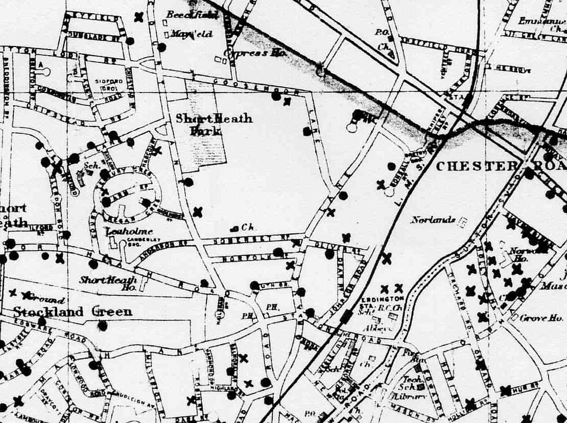
Lane Area War-Damage Map(Birmingham Central Library)
Here is the nearby section of the fabled Birmingham wartime-bomb map. By common consent this is not entirely accurate. It was drawn up by outsiders sent to the area after each raid (compiled at the end of the war onto one map). The X's mean unexploded (see an error by Court Farm School? That was a UXB). The raid down by opposite Cookes is not on it but so many elderly residents have said it occured so that's another map error). The dots in the original colour-map mark incendaries and high-explosive bombs differently. Crashed Luftwaffe planes are marked by a small aeroplane on the complete Birmingham one too, no marks like that above. (Few are marked on the big one though either, suggesting few were shot down!)
Interesting to note that it seems often a later road's junction was later built where bombs had exploded (Top Croft/Goosemoor, Jarvis Road/Top Croft Road etc). Out of shot above ones landed where the Fosseway Drive and Guthrum Close junctions with Court Lane junction now are too (nothing on Sycamore Road or Beech Road). Since Top Croft etc were all built some twenty years after, they presumably didn't rebuild the house etc between that time. This may explain Jarvis Road's weird route. Perhaps it had to bend round the pre-existing church to two points of bomb blasts on pre-existing roads. So perhaps Hitler not only built Germany's motorways, but he inadvertently created the routes of some of our later roads as well!
In Sutton Coldfield bombs fell even down by the Boldmere Road/Jockey Road junction area etc. The closer to the City Centre or heavy industrialised areas the worse it was, much worse.
Goosemoor Lane Area Dead From Air Raids
On Goosemoor Lane
| Surname | First Name(s) | Age | Date | Killed At | Lived At | Air-Raid Job |
| Bradnock | Elsie Heath | 18 | 10/4/1941 | Number 35 | Same | None |
| Evans | William Everett | 58 | 10/4/1941 | Number 44 | Same | Fire-watcher |
| Fidoe | Norman Edward | 36 | 10/4/1941 | Number 46 | Same | None |
| Foster | George | 62 | 10/4/1941 | Number 69 | Same | Fire-watcher |
| Gilmor | John | 61 | 9/4/1941* | Stones Laundry | 18 Newman Road | None |
| Goodwin | Alfred John | 34 | 10/4/1941 | Number 66 | Same | None |
| Green | George | 46 | 10/4/1941 | Number 78 | Same | Fire-watcher |
| Harris | Bert | 25 | 10/4/1941 | Number 85 | Same | None |
| Harris | George James | 62 | 10/4/1941 | Number 52 | Same | None |
| Morgan | Elsie | 26 | 10/4/1941 | Number 29 | Same | None |
| Morgan | David John Edwin | 18 | 10/4/1941 | Number 29 | Same | None |
| Stanley | Albert Edward | 56 | 10/4/1941 | Number 98 | Same | None |
On Sycamore Road
| Surname | First Name(s) | Age | Date | Killed At | Lived At | Air-Raid Job |
| Edgerton | Charles Henry | 67 | 20/11/1940 | Flat 8 (back of 40) | Same | None |
| Harris | Clara Eliza | 75 | 12/13/1940 | Number 85* | Same | None |
*There is no number 85 (ends at 77). 85 Goosemoor Lane had Harris's, also casualties at a different time (related to those at 52). Not a known mix up though, it does say 85 Sycamore Road Erdington in the Commonwealth War Graves list. Anyone know why? That junction has the little island now but substantially it's been like that since about 1909, i.e. no old Sycamore houses at that end have gone.
On Gravelly Lane
| Surname | First Name(s) | Age | Date | Killed At | Lived At | Air-Raid Job |
| Guscott | Ernest Charles | 10 | 10/4/1941 | Number 237 | Same | None |
| Guscott | Dorothy | 39 | 10/4/1941 | Number 237 | Same | None |
| Parker | Leonard William | 34 | 30/7/1942 | Number 147** | Same | Air Raid Warden |
* Died the following day.
** Fatally injured and died later in hospital
The Commonwealth War Graves Commission website has a complete database, www.cwgc.org.uk
(Roads searched on were - Abbeyfield Road, Anderson Road, Beech Road, Bonsall Road, Bretby Grove, Chipstead Road, Cossington Road, Court Farm Road, Court Lane, Dean Road, Dunslade Road, Enstone Road, Flackwell Road, Glendon Road, Goosemoor Lane, Gravelly Lane, Gretton Road, Hayland Road, Highfield Drive, Ilford Road, Jerrys Lane, Johnson Road, Knipersley Road, Madehurst Road, Norfolk Road, Oliver Road, Raford Road, Sheddington Road, Short Heath Road, Somerset Road, Station Road, Sycamore Road, Tedbury Crescent, Turfpits Lane, Witton Lodge Road).
Remember many current roads did not exist during WWII.
Goosemoor Lane Air Raids
The Luftwaffe scored hits in the area opposite what is now Cookes
Furniture (about 4 houses but others damaged too). There is now
modern-looking housing near the end shop on the odd-side of
Goosemoor, that is it. A female ARP warden was killed (an ARP
station was there). On Enstone Road the first bomb on Birmingham
fell (8th/9th August 1940). Casualty reports vary (this is that D
Notice again).
One says some members of a Goosemoor Lane family decided against the Anderson Shelter in their back garden in favour of their beds (intending for one night it seems) with fatal consequences (this may have been the Morgans - click the bomb map). Another told me large numbers of people lay dead in the road where the zebra-crossing now is (this probably from the big April 1941 raid). The target was the Spitfire (now Jaguar) factory in what is now Castle Vale. It's assumed the Stones laundry building (which was where Cookes now is) was mistaken for the Spitfire factory (or part of it) from the air (it's roof had been camouflaged like many factories).
We now know why so many house numbers are "missing" in the street opposite Cookes - the Luftwaffe again. The rebuilt houses are much bigger so couldn't fit as before.
(If you walk round the corner onto Gravelly Lane you'll see the same "gap" in house style next to the shop. That was a delayed action bomb going off later in the day).