James Gooldy Family
Research into the Location of Timberlake Mine
Some research done by Karl & Laurie:
Starting with James Gooldy's obit. and an old unlabeled, undated
photograph we used the internet to come up with a possible location
for "Uncle Jim's" (Timberlake) placer operation South of Baggs.
We know from James Gooldy's obit.: "Mr. Gooldy entered the placer
mining game, and was instrumental in securing eastern capital to
finance the Timberlake Mining Company's gold mining activities in the
placer fields south of Baggs. He had charge of the construction of the
famous Timberlake ditch and pipeline which had its head in the Roaring
Fork of Slater Creek and cost over $80,000 [1890's dollars!] to build."
Karl's proposed location:
10.4 miles airline south of Baggs, WY
Northern Moffat county, CO
Approx. 40.87412 degrees north lat. and 107.65365 degrees west lon.
Approx. altitude of 6560 to 6590 feet
South 1/2, SW 1/4, section 30, T 11 N, R 91 W
Please ask Karl for the reasoning behind this conclusion.
(He has a PowerPoint presentation.)
Map of General Area:
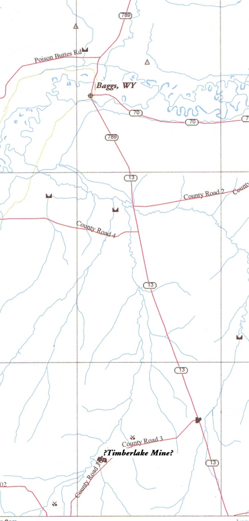
Karl has followed (on USGS Aerial Photos) a feature that may be the
Timberlake Ditch to a spot near Timberlake creek. See following examples.
?SW End of Timberlake Ditch?
Larger Scale USGS Aerial Photo of area
The BLM website has a copy of a Mining Patent for James Gooldy.  This patent
is maybe a mile Southwest of the above location.  It is about a mile farther up
East Timberlake creek.  It is approximately a mile downstream from the mine
symbol on the above map of the area....

Mining patent information from the BLM web site follows:

You searched on: State=COLORADO, First Name=James, Last Name=Gooldy

GOOLDY, JAMES  CO  Moffat  1/16/1917  Glenwood Springs  09714  562024

Accession/Serial #: 562024   BLM Serial #: COGS 0009714

Names
Patentee: JAMES GOOLDY
Survey
State: COLORADO
Acres: 40
Metes/Bounds: No

Title Transfer Issue Date: 1/16/1917
Land Office: Glenwood Springs
Cancelled: No
U.S. Reservations: Yes
Mineral Reservations: Yes
Authority: April 24, 1820: Sale-Cash Entry (3 Stat. 566)

Document Numbers:
----------------
       Document Nr.        : 09714
       Accession/Serial Nr.: 562024
       BLM Serial Nr.      : COGS 0009714

Block  Section  Township  Range  Fract.Sec.  Meridian  State  Counties
----------------------------------------------------------------------
  4      36/     11-N      92-W     No        6th PM    CO     Moffat
Remarks: LOT 4 OF SE
Click HERE To See Document Image
Click HERE for a recent Plat from Moffat county Assessor's office.
This shows the location of Lot 4.
Click HERE for annotated USGS topographic quad
Annotations are Karl's and very approximate!
Mining Claim Patent Info. can be searched for found HERE
James Gooldy Family