) Map: Kalasa, nearby Kudremukh
Map: Kalasa, nearby Kudremukh
 Map: Kalasa, nearby Kudremukh
| Geo | | Map | | Route | | Fact_sheet | | The Trek | | Other Trails | | MyPix | | BirdList | | Linx |
Geo Info : |
|
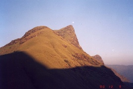
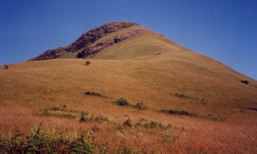
Kudremukh literally means Horse's Face beacause it appears so when seen from the sea; This was well-known landmark for ancient sailors.
| Why the author of National Geographic Magazine's feature on Western Ghats (Jan 2002) speaks about Kudremukh as his "worst" experince of his assignment.. |
* Hmmm... its gonna be some 30-40kms thru the hills in two days !.. We r all geared up.. By 9:30 we started from Samse, crossing a stream.. meandering mud road thru coffee plantations.. we reached our first PitStop for refilling with Bananas, Chocolates.. it's a 2-room-primary-school courtyard.. near sparsely populated hillside farm areas..
* Next target is Lobo's House [ Lobo Mane ].. as we were told.. we were wondering what Mr Lobo has got to do with this place ? started getting tired cos it was hot and sunny.. then we came across a stream with cool wooded area only along its banks.. outside, it's mostly grasslands.. which is the general pattern of the terrain out there.. and for crossing the streams at some places, there's just one or two tree trunks laid across.. difficult task for us to balance on them.. one by one we stepped gingerly..
* Then there's a repeat of such feats.. we went thru grasslands followed by temperate forest, popularly referred to as 'sholas' and characterised by a dense closed canopy.. here it's isolated, only along the streams thru the narrow 'grooves' of the hills..
 *
Planned for lunch after reaching Lobo's place.. some villagers
helped with directions.. we reached large expanse of grasslands on the slopes..
and there we chanced upon two concrete crosses in the midst of the grass..at the base of a hill..
I tho't may be that's Lobo's ?! Thus clearing the mystery about this name 'Lobo',
hw must've been a missionary..
we grew more hopeful about finding his house nearby.. finally it's around 4
when we could spot it.. behind thick growth of creepers.. looking abandoned, and
haunted.. but apparently some villagers from the hamlet that we crossed keeps the key..
and sometimes lets the trekkers stay there overnight..
our idea was just to cook in its courtyard,
eat and carry on till sundown. After gathering some firewood, we got the upma ready
quick.. and some bread & jam. While getting water from a nearby stream, I got
one unusually large black&yellow butterfly lying dead.. picked it up for Luke
to try some tricks with his new SLR to make it look alive on a large flower.
*
Planned for lunch after reaching Lobo's place.. some villagers
helped with directions.. we reached large expanse of grasslands on the slopes..
and there we chanced upon two concrete crosses in the midst of the grass..at the base of a hill..
I tho't may be that's Lobo's ?! Thus clearing the mystery about this name 'Lobo',
hw must've been a missionary..
we grew more hopeful about finding his house nearby.. finally it's around 4
when we could spot it.. behind thick growth of creepers.. looking abandoned, and
haunted.. but apparently some villagers from the hamlet that we crossed keeps the key..
and sometimes lets the trekkers stay there overnight..
our idea was just to cook in its courtyard,
eat and carry on till sundown. After gathering some firewood, we got the upma ready
quick.. and some bread & jam. While getting water from a nearby stream, I got
one unusually large black&yellow butterfly lying dead.. picked it up for Luke
to try some tricks with his new SLR to make it look alive on a large flower.
Later we came to know that it was Southern Birdwing (Troides Minor), largest Indian Butterfly !.. with a wing-span 140-190mm. It is abundant in the Western Ghats during monsoon and immediate post-monsoon months. Active during early morning hours with a slow flight, usually high above the trees.. Frequents shady walks and glades in the jungles and comes down from tree tops to feed on Lantana, Mussaenda etc. |
* Now since there's no hope for villagers to be around to ask directions, we felt a little lost.. though had a general idea of direction there was no clue about the shortest trail.. or one which can lead us to a place where we can camp for the night.. for which proximity to clean water streams/ springs is a must.. we lost some time exploring what seemed to be trails thru tall dry grassfields.. later they turned out to be dried-up narrow water channels..
 *
Then onto a beautiful purple patch of flat grassland.. which seemed to end near
the thickly wooded area at the base of the steep slopes to the way up..
and from distance saw a dilapidated old mudhouse at the base of the slopes..
and it was getting dark.. a sense of emergency crept in.. I dumped my backpack
and ran thru the purple grassland towards the mudhouse for a quick reconnaissance..
though one side of it looked creepy with thick undergrowth into the rooms with
falling roof,
there was some clearing on the backyard.. also there's some firewood around..
someone had camped there recently..
.. Ah.. so possibly we are on the right trail.. Kool.. Mission Success, I waved
to guys..yelling.. we decided to pitch the tent in the clearing next to the mudhouse..
*
Then onto a beautiful purple patch of flat grassland.. which seemed to end near
the thickly wooded area at the base of the steep slopes to the way up..
and from distance saw a dilapidated old mudhouse at the base of the slopes..
and it was getting dark.. a sense of emergency crept in.. I dumped my backpack
and ran thru the purple grassland towards the mudhouse for a quick reconnaissance..
though one side of it looked creepy with thick undergrowth into the rooms with
falling roof,
there was some clearing on the backyard.. also there's some firewood around..
someone had camped there recently..
.. Ah.. so possibly we are on the right trail.. Kool.. Mission Success, I waved
to guys..yelling.. we decided to pitch the tent in the clearing next to the mudhouse..
Now we need to find some freshwater source before darkness creeps in.. .. luckily, it was almost-full-moon .. Luke's searching, listening for flowing water.. he comes back.. Thumbs Up ! .. found a very narrow brook across the field.. Wow.. we geared up.. things are in place for a grreat moonlit night by the campfire.. We howled like a wolf-pack.. Moon in the background.. echoes from the hills..
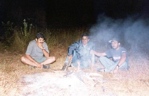 Nandu,Pamz prepared hot soup for us while I tried to light Campfire..
Hot noodles followed.. cozied up near the fire.. before winding up, we
did the REC-Zulu tribal dance around the fire with the Zulu song..
Nandu,Pamz prepared hot soup for us while I tried to light Campfire..
Hot noodles followed.. cozied up near the fire.. before winding up, we
did the REC-Zulu tribal dance around the fire with the Zulu song..
and dedicated it to all our Tribesmen of CREC batch..OH.. NAKO.. NAKO..NAAMAA....
NAKO...KONAAMAA....
NAKONAAMEE.. NAYYO....
GARRMANAAYO.. THIMAAMAA....
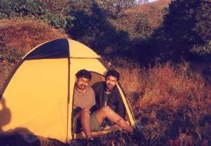
Night getting cold as steel.. the tent is up in minutes and we are flat..
I didn't bring sleeping bag since had to carry the tent.. somehow managed with my
Aluminium coated polythene emergency pocket-blanket.
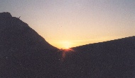 Dripping dew from the tent wakes me up.. Ah.. so fresh a morning.. added to it a
Golden Sunrise.. right on the hill we are facing.. across the fields..
Now the high point is the bath in the deep narrow ditch-like channel thru which
the springwater flows.. its so invigorating..
Dripping dew from the tent wakes me up.. Ah.. so fresh a morning.. added to it a
Golden Sunrise.. right on the hill we are facing.. across the fields..
Now the high point is the bath in the deep narrow ditch-like channel thru which
the springwater flows.. its so invigorating..
After upma breakfast, we think about the strategy for the rest of the day.. still not sure about the trail.. just then heard some ppl descending from the peak, listening to their echoes.. we shouted back to sense their direction.. seemed coming closer.. and after some time, they emerged from behind the trees right into that compound.. yes.. we r right on the trail..
we felt it's not practical to carry all the backpack thru the steep climb.. dumped in the tall grass next to a tree and marked the tree.. and carried on.. interesting view of the valleys as we leave behind one hill after the other.. when going thru the narrow trail between tall grasses, suddenly I felt something slithering just next to my legs.. the next moment I remember, I got thrown back 2 meters in quick reflex.. lying on the grass with elbows supporting.. must've been a snake.. we waited.. listening for its movements.. wasn't any..
 we carried on..
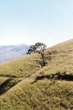
undulating terrain .. grassland interspersed with strips of shola forests..
there are more camping sites on the slopes.. luckily no leeches this time of the
year..
we carried on..
undulating terrain .. grassland interspersed with strips of shola forests..
there are more camping sites on the slopes.. luckily no leeches this time of the
year..
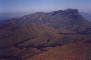
The view of the lower hills and the valleys when you approach the top is exhilarating..
you feel it's worth the Climb.. you feel elated.. you r on a High..
On our way back, we stopped by a stream, did skinny-dip (except Nandu, feeling shy),
Pamz scratched head.. to freak or not.. but later plunged.. boldly :)
Freshened up, had lunch we had packed and kept in aluminium foils, attacked
the rest of the chocos, and left.. when we landed back in Samse, it was past 6pm..
in time for the return bus @ 7.
******
Other Trails:
Kudremukh National Park:
Abt 600sqkm.
The Park is home to the Sambhar,Gaur, Chital, Lion-Tailed Macaque, panther and leopard.
The park also had tented campsites managed by the forest Dept.
Contact: Forest Dept office, Aranya Bhavan , Bangalore or Forest Officer, Kudremukh town for Reservn.
Other places nearby:
Gangamoola - Scenic place located in the Bhagawati Forest which can be approached by trekking .
In Samse Taluk of Chikmaglur district, the Gangamoola Hill is surrounded by thick forests. Three important rivers,
the Tunga, the Bhadra and the Nethravathi have their origin here.
A shrine of Goddess Bhagavathi and a Varaha image measuring 1.8 m within a cave, are the chief attractions. This cave
is inaccessible during the monsoons.
Checklist of Birds reported from Kudremukh National Park
Frontline Magazine (Sep 2001) Article - Environment - KUDREMUKH CONCERNS: