| leadhills |
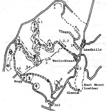
Route 1 22km, 250m climb 1km south of Leadhills village a track leads west up to Hunt Law then east and north to Rake Law. The track is faint on the cast side of Rake Law but improves from the ruin of Glendorch and becomes tarmac after Snar Farm. Turn left on to the B740 and left into the forest after 5km just before Spango bridge. Keep left 7km to Wanlockhead and refreshments at the lead mine museum tea room. A lead mine tour and display is available |
| Route 2, 28km, 300m climb Parking is convenient at the north end of Wanlockhead at the side of the B797. Freewheel almost 7km south to the turn off to Auchentaggart (1km before the A76). Follow the track through Auchentaggart to Bogg and keep right on the tarmac road to Glenries and Mossholm. About 1/2 km before Nether Cog go right into the forest. The forest track twists and turns for 6km then keep right 5km back to Wanlockhead. |
| Route 3. 23km, 600m climb Note that the route should be avoided in the shooting season. From the parking a described for route 2 ascend Stake hill toward Lowther Hill. At Whiteside turn off at a hairpin bend on the tarmac road onto a footpath. Contour and ascend East Mount Lowther descend south west 1km then south beside Lang Cleuch turning west at the bottom to Glenim. The track from Glenim to the B797 is fast and enjoyable. Turn left on to the B797, right after 3km to Auchentaggart and 4km to Bogg. 200m after Bogg turn right on to the Southern Upland Way. 3km to Cogshead ruin, continue on S.U.W. over Glengaber Hill. A speedy descent and right turn leads back to Wanlockhead. ---------------------------------------------------------------------------------- |
 |
 |