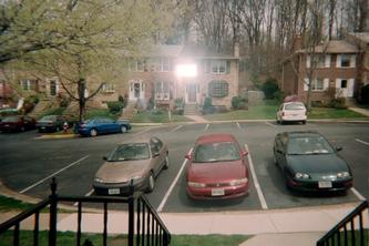
The picture above was taken from my front window. It matches the
satellite pic of my GPS coordinates on Google Maps. Do you see how there is one metallic brown car and one red car in the parking spaces in front of my townhouse?
However, there is just one catch.... the picture above was taken in 2001 or 2002. I have not owned either of those cars since 2005. That means the version of the satellite picture used on Google Maps is at least three years old for my particular location. There are plenty of other examples I can find that show how out of date it is- new shopping centers that were built years ago that show up as dirt lots with construction equipment.
Want an example? Do a radius search around my address for "
Wegman's." Now select the first one listed, on Monument Drive in Fairfax, and zoom in all the way. Voila! Dirt lot. We were just there a few days ago so I know it is there. It has been open for at least two years.
Here is another one-
try it yourself. The "A" is a new Whole Foods store where we shopped Saturday night, next to a "Maggie Moos" icecream which is the green arrow. With the map labels on, you can clearly see "Market Commons Drive" crossing the grass near the baseball field. Only problem is, Market Commons Drive is now lined with shops, and the baseball diamond is now luxury condos.
Coincidence- You Make The Call Here are the
GPS coordinates for the tree that fell on Hummer Rd in Annandale so you can see
how close it is to my house. The earthquake epicenter, the tornado/falling tree, and my house almost make an
equilateral triangle (ignore the driving distance).