The other factor that I have not seen reported in the news is the HIGH TIDE/FULL MOON factor. The full moon occurs this Sunday but if you saw the moon last night you know it is nearly full now. The previous full moon was a partial lunar eclipse, so it was particularly well aligned. This weekend's full moon is the HARVEST MOON, the moon closest to the equinox.
In the case of a fast moving or more compact storm than Ike, the TIMING of landfall is critical. If the storm comes in at HIGH TIDE, that makes the storm surge even more devastating. If it comes in a low tide, that can actually work in your favor, or at least minimize some of the effect of the surge if the tide is going OUT rather than IN.
But unfortunately, IKE is both a LARGE storm and it is moving SLOW. Hurricane force winds extend out 150 miles from the eye in all directions, and the storm is moving at around 12 mph. That means that for locations on the eventual path of the storm, they will experience winds of 75 mph or greater for a period of 10-12 hours, then the winds will reverse and they will experience 75+ mph winds for another 10 hours from the opposite direction. The storm surge is being pushed ahead of the storm by the counter-clockwise cyclonic winds on the east/right side of the storm as seen on the satellite picture. The storm is moving WNW at this time, and Galveston Bay is on the right (or I should say WRONG) side of this circulation. The storm surge effect will continue for a period of 12-24 hours(!) starting this afternoon and continuing all through the night until the anticipated landfall time of 2 AM and beyond.
A landfall between midnight and 2 AM is the WORST possible landfall time in this scenario! During the 12+ hour period of maximum storm surge, every place along the coast will experience HIGH TIDE some time during this 12 hour window. For a big chunk of the time the storm is approaching land, the incoming tide will be contributing to the storm surge, and because it is also a nearly full moon, the high tide is 4-5 feet higher than normal. So Galveston Island will experience a storm surge of 20 feet, with a high tide that is 4-5 feet higher than the normal high tide, and then 30+ foot high waves ON TOP OF THAT!
I hate to say this but I think the emergency authorities in Houston may have made another mistake by telling people to shelter in place rather than evacuate(!). I hope I get proven wrong. When hurricane Rita hit almost exactly three years ago this month, they issued an evacuation order for Houston, and people drove "inland" to the TX/LA border region, which turned out to be the place most devastated by the storm. The traffic jams were so long people ran out of gas on the highway. According to something I read online, over 100 people were killed in traffic-related incidents, while only ten people were killed by the storm itself. So telling people NOT to jam the roads is probably a good decision, except that in this case, it really does look like Houston is going to get POUNDED.
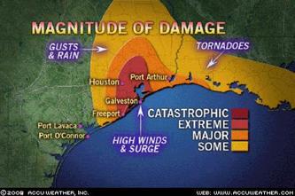
Look at this
map of Houston and how thin Galveston's barrier island is. Here is a
zoomed in section of homes in Galveston itself. It is hard to wrap your mind around what it is going to like when all the hundreds of homes shown in the satellite picture are going to be under water. Like I said earlier, not a gradual trickle as the levees leaked and New Orleans filled up like a bathtub. Not quiet tranquil standing water coming up to the edge of the foundation. All the buildings, all the structures, all the streets shown in this satellite are going to be under 30 feet of violent raging crashing waves. It is going to look like a scene from that movie "The Day After Tomorrow," except that nobody will be able to take a picture of it. At its widest point where I-45 enters the island from the mainland, the city of Galveston is no more than 20 blocks across. It's a little like Ocean City MD in that respect. The other barrier island on the east side is less developed, non residential area... that will probably be completely submerged and the gulf waters will just pour right over it into Galveston Bay itself. It is hard to imagine downtown Houston with the big sky scrapers under water, but it is not hard to look at the map and imagine the eastern half of the city from the Port of Houston to Baytown to be completely under water.
If there was ever a time it would be appropriate to PRAY, now is the time.
I will be glued to the Weather Channel tonight. Stay SAFE out there!