High season for traveling to the Yucatan is December through February. The dry season is October through May. As is our usual approach, we timed this vacation so we would be traveling in the off-season. Off-season travel means reduced crowds and costs, however it can also mean reduced attractiveness of the destination. For example, few want to visit an exotic location during its rainy season or the Nordic countries during their winter. Optimally, we vie for the "shoulder season" just before the crowds hit and the prices rise or just after they leave and the prices drop.
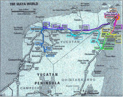
In crafting an itinerary for our vacation, we researched tourbooks, history books, and websites. We identified places of interest to us throughout the region and how long visits to them might take, then we determined how many can be tied together in a travel route that fits a reasonable vacation duration. Here is our pre-vacation list of "places to see and things to do" and our planned itinerary. Following that is a map showing the path we took during our trip. It fairly closely follows the planned itinerary. It is rainbow color-coded to indicate the passage of time. As can be seen in the list and map, our trip would involve visits to the Mexican states of Quintana Roo and Yucatan.
Places To See, Things To Do by Mexican State
Quintana Roo
- Cancún
Ciudad Cancún (Cancún city) is the commercial and business backbone, budget hotels, local restaurants
Isla Cancún is an elbow shaped sandbar 15 miles long and 1/4 mile wide (Hotel Zone, shopping, golf; flanked by Nichupté Lagoon and Caribbean Sea)
Beaches (parasailing, snorkeling); Playa Linda (4km marker), Playa Chac-Mool (10km)
Laguna Nichupté (clear waters, small islands in lagoon, snorkeling, water skiing, jet skiing, parasailing)
Ruinas El Rey (small ruins at southern end of Isla Cancún); close by Kukulkán site (one building)
San Miguelito ruins (small ruins at southern end of Cancún Island)
El Meco Pyramid
Glass bottom boat rides (from Kukulkán)
- Isla Mujeres (tiny island 4 miles offshore from Cancún; crystal clear waters and great snorkeling; 45 minute ferries leave every hour, bike or taxi to get around)
- Puerto Morelos (20 miles south of Cancún. Don't take car from Puerto Morelos to Cozumel; ferry may stay docked in bad weather, must arrive hours before it departs, and it takes 2-3 hours for the trip)
Swim with harmless, gato sharks
Playa Lancheros; children can swim with giant sea turtles, dolphins
Nude beach (Caribbean Reef Club)
Fabulous snorkeling 550 meters offshore
- Playa del Carmen; a.k.a. Playa (41 miles south of Cancún, jumping off point for boats to Cozumel Island)
Nude beaches
Cove with shallow waters and sunken Spanish galleon to explore via snorkeling
- Cozumel Island (island 11 miles offshore from Playa del Carmen; less hectic, leave car behind when ferried there; may need to taxi to get to sites)
- Xcaret (4 miles south of Playa del Carmen)
Chancanaab Lagoon
Museum of the Island of Cozumel
Palancar National Submarine Park (snorkeling, beaches)
Cozumel Archaeological Park
All-day waterside theme park the highlight of which is donning a life jacket and floating with the currents of an underground river through caves to the beach, swimming in dolphin pond, snorkeling in underground lagoons (no suntan lotion), night show
Xpu-Há as an option
- Akumal (16 miles north of Tulum; diving center, relatively expensive)
- Xel-Há (10 miles north of Tulum)
Coconut tree lined beaches, snorkeling
Giant sea turtle nesting grounds (May-October)
Yalku Lagoon
Bridges built over lagoons, snorkeling, restored Maya ruins, swim with dolphins
- Tulum (77 miles south of Cancún, seaside ruins; southernmost point of trip)
Tulum ruins (dramatic setting--the only significant Maya site on a coast--and walled fortification)
Chemuyil (13 miles north of Tulum, campground if desired)
Chunyaxche (rarely visited ruins, tours through canals to jungle lined lagoons, wilderness)
Sian Ka'an Biosphere Reserve (few miles south of Tulum). On the road towards Punta Allen is a journey through majestically thick jungle alive with birds, lizards, snakes, monkeys, and butterflies. The beach areas can swarm with mosquitoes. (Leave Tulum with a full gas tank.)
- Cobá (on road from Tulum to Valladolid)
Site of extensive, pristine ruins in jungle setting; visit early in morning
- Valladolid (26 miles west of Chichén Itzá)
Cenote Zaci (huge sinkhole 2 blocks east of main square; bats)
Dzitnup cenote (2.5 miles southwest of town) swim in sunlit cavern pool
Biking
- Chichén Itzá (125 miles west of Cancún, most impressive, best known and most visited ruins)
Full day's worth of ruins to visit (night sound and light show). Inside the large pyramid of El Castillo is an older temple that can be entered twice a day (check times at visitor's center). In the ballcourt, check the acoustics by standing at either end and talking to each other.
Balancanche Caves (has alters in niches, blind fish in pool)
- Mérida (523,000 people, capital of Yucatan)
Sunday streets are closed and everyone comes out in their Sunday best clothes, concerts, flea markets, party atmosphere
Mexico's version of Champs-Elysées
Various but not compelling museums (Anthropology & History Museum is best bet but also city, archeological, and natural sciences museums) and architecture
Dzibilchaltún (9 miles north of Mérida) ruins in which one can swim in the clear water of the Xlacah cenote which was once a sacrificial well
- Uxmal (49 miles south of Mérida)
Full day's worth of most beautiful ruins to visit (night sound and light show)
- Ticul (56 miles south of Mérida) one night stand for Uxmal and sights below
Puuc ruins of Kabah, Sayil, and Labná
Mayanpán (35 miles southeast of Mérida) Maya capital for two centuries, it's fall ended Maya greatness (few visitors)
- Izamal (46 miles east of Mérida) religious center of Itzaes
Franciscan Monastery (enormous church built on top of a pyramid)
Kinich Cakmo Pyramid (one of Mexico's largest pyramids, can climb to its top)
Tentative Itinerary
| Sunday | Monday | Tuesday | Wednesday | Thursday | Friday | Saturday |
| Leave RDU 2:00, arrive 6:00 Beaches (Cancún) |
Isla Mujeres
(Cancún) |
|||||
| Lagoon, Cancún city, pick up car, Local ruins
(Cancún) |
Local ruins,
Puerto Morelos
(Playa) |
Cozumel Island
(Playa) |
Xcaret
(Playa) |
Playa del Carmen,
Akumal,
Xpu-Há(??) (Playa) |
Xel-Há,
Tulum,
Chunyaxche / Sian Ka'an (Tulum) |
Cobá,
Valladolid, Chichén Itzá light show? (Valladolid) |
| Chichén
Itzá
Drive to Mérida (Mérida) |
Mérida
(Mérida) |
Uxmal
(Ticul) |
Puuc ruins,
Mayanpán (Mérida) |
Dzibilchaltún,
Izamal,
Drive to FAVORITE SPOT (???) |
FAVORITE SPOT
(???) |
Cancún
Leave 4:00, Arrive 10:00 (Cary) |
Notes:
- Parenthesized city name at the bottom of each day indicates the place in which we spend the night.
- FAVORITE SPOT days can be moved from the end of the vacation to an earlier day. For example, if bad weather cancels plans for one day whose activities are not easily shifted, we can stay an extra day there to recover. If we especially enjoy a place we can linger an extra day. We may also learn of attractions we did not anticipate and want additional time to enjoy them.
- Chichén Itzá is free on Sundays.
The map belows shows the path we actually took on our vacation. It is rainbow coded from red through violet to our last day in Puerto Moreles (red-violet). In many cases, we traversed the Mayan Route (the dotted line).
| Back to Curt, Missy, and Eric Homepage | Back to Start of Yucatan Vacation | Back to All Diaries |
© 1999 [email protected]