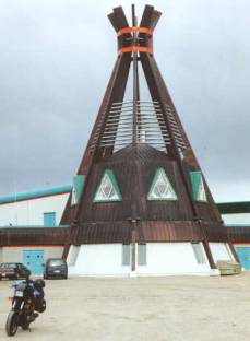
Day 2: La Verendrye Provincial Preserve to James Bay Road km 273 - 417 miles
The next morning when I hit the road, I droned at 50 again. I finally went on reserve at 168 miles. Hmmmm.
168 miles on 3 ¼ gallons, maybe another gallon reserve, and a whole 2 ½
gallons on the back. Yep, 240 miles
would be a piece of cake. I now knew
that 50 mph would get me across the upcoming long stretches.
Knowing my fuel situation, I picked my speed back up to 80, passed through
Val d’Or, stopped for groceries in Amos, and stopped for lunch and gas in
Matagami. Pulling out of Matagami I
pointed my front wheel up the James Bay Road and kept my speed under 50 mph. A few kilometers out of town I stopped at a
checkpoint. They like to keep tabs on
who is on the road, so when they don’t check out they know to start looking for
them. I got some maps, info about the
road, and continued northward. Pulling
away from the checkpoint, I thought, “Wow, I’m here.”
 The
James Bay Road is awesome. It’s
beautifully paved, passes through beautiful surroundings, and there’s hardly a
soul around. It killed me to have to
limit my speed, but knowing that the alternative was being stranded out the
middle of nowhere (albeit a beautiful nowhere), I found the strength to go
light on the throttle. It was a nice,
relaxed drone northward. I noticed that
the farther I rode, the smaller the trees got, and it was getting cold. I was entering the taiga, a sub-arctic
forest land populated by short, stunted trees which grow maybe two centimeters
a year due to the short growing season.
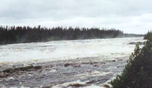
At kilometer 257 I crossed the Rupert River and snapped some pictures of
an absolutely enormous set of rapids.
With the sheer power of the river so evident, one can see why
HydroQuebec was attracted to this region.
The
James Bay Road is awesome. It’s
beautifully paved, passes through beautiful surroundings, and there’s hardly a
soul around. It killed me to have to
limit my speed, but knowing that the alternative was being stranded out the
middle of nowhere (albeit a beautiful nowhere), I found the strength to go
light on the throttle. It was a nice,
relaxed drone northward. I noticed that
the farther I rode, the smaller the trees got, and it was getting cold. I was entering the taiga, a sub-arctic
forest land populated by short, stunted trees which grow maybe two centimeters
a year due to the short growing season.
At kilometer 257 I crossed the Rupert River and snapped some pictures of
an absolutely enormous set of rapids.
With the sheer power of the river so evident, one can see why
HydroQuebec was attracted to this region.
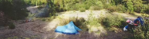
It was time to start looking for a place to camp. A few more miles north I came across a quarry along the
road. Tucked back into a corner behind
some trees, I was shielded from the road.
A half-hour later I had my tent set up, a fire roaring, and had some
soup cooking on the stove. I pulled a
beer out of one of my saddlebags, popped it open, and toasted the scenery. One word came to mind: “Awesome.” Camping in the lower 48 is one thing, when
you know that people may be just a couple miles away. It’s entirely different to know that, aside from maybe a few
campers like yourself scattered here and there, the nearest person is most
likely a Cree Indian in Nemascau about 50 miles away. This was reasonably remote adventure touring, and a mere two
days’ ride from the hustle and bustle of New England!
Day 3: James Bay Road km 273 to James Bay - 307 miles
The next morning after the usual coffee ritual, I broke camp. I decided I had burned enough gas to empty
the extra 2 ½ gallons into the tank. I
pulled everything together and continued north. After an hour or so I reevaluated my fuel situation, decided I
had plenty to make it to km 381, and picked my speed back up to a more
invigorating pace. Left, right, up,
down, mile after mile, the James Bay Road is a great ride. It was cold and rainy, but the road made up
for it. I soon crossed the Eastmain
River. HydroQuebec diverted this one
into the La Grande watershed to increase the volume going through their hydro
dams. There was only a small river
trickling down a wide rocky riverbed. I
could only imagine that in its virgin state it had looked like the amazing
rapids on the Rupert River. A while
later I pulled into km 381, frozen to the core. I ordered some bacon and eggs and sucked down a lot of hot
coffee.
The guy at the counter said it was 45 degrees out and it was the coldest
weather they’ve had in July in 20 years.
If I hadn’t been wearing the Cortech suit I just bought before leaving
home, I would have been in a lot of trouble.
As it was, the suit gave me enough protection to keep me warm and dry
for a few hours at a time. My hands and
feet would go numb in minutes, but with the suit it was a couple hours before I
started shivering uncontrollably – plenty of time to make it to the next
oasis! After an hour or so of warmth
and caffeine, I gassed up and continued north.
One hundred and forty cold and rainy miles later I went on reserve on the
outskirts of Radisson. I reached down
to flip the petcock, but I didn’t have enough strength in my frozen hand to do
it. I coasted to a stop then used both
hands. I fired the bike back up and
rolled the last couple miles into town.
I visited the HydroQuebec office and asked about a tour of the
hydroelectric facilities. It was about
12:15 and they were running a tour at 1:00 – a big bus for about 30-40
people. But the tour was in
French. With a little checking in the
back room, they told me to come back at 2:00 and they would give me an English
tour.
In the time I had before the tour, I gassed the bike, bought a large blue
tarp at a hardware store, and got some lunch.
I parked the bike in the rain in the HydroQuebec lot, and covered it
with the tarp. I don’t know why, but I
feel a bike is better suited to be out in the nasty weather if it’s
moving. If it’s just sitting there in
the rain, I have this need to cover it.
If my bike is going to treat me so nice for so many miles, I feel that’s
the least I can do for it to return the favor.
I checked in at the office and they set me up with my guide – a very
attractive woman named Marie-Pierre. A
student in Quebec City, she was working for the summer in Radisson. She spoke excellent English, but
occasionally lacked a word that I was usually able to fill in. Since I was the only English-speaking
tourist around, the tour would be one on one – just Marie-Pierre and me. We hopped into a minivan and headed off.
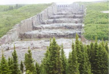 We
drove by the transformer forests, drove across the dams, we stopped at the
spillway they call “the giant’s staircase”, and we drove to the
powerhouse. Through some huge doors, we
drove inside and down a long ¼ mile underground ramp. We walked into the powerhouse and saw the tops of the sixteen 333
megaWatt generators. We walked down
some stairs and in through another couple of airlock doors into a small, very
windy room. In the center was a 1-meter
diameter shaft spinning at 133 rpm, and overhead the 5-meter diameter armature
was spinning at the same speed. Below
our feet was the turbine, being spun by a huge flow of water. We were standing inside a 333
megaWatt generator! Again, the word
“awesome” came to mind. We climbed out
of the generator and went through more airlock doors into the surge chamber. This was a huge cavern about 500 meters long
into which all sixteen generators dumped their water. We stood on a small catwalk near the ceiling, looking down on a
huge sea of roiling water.
We
drove by the transformer forests, drove across the dams, we stopped at the
spillway they call “the giant’s staircase”, and we drove to the
powerhouse. Through some huge doors, we
drove inside and down a long ¼ mile underground ramp. We walked into the powerhouse and saw the tops of the sixteen 333
megaWatt generators. We walked down
some stairs and in through another couple of airlock doors into a small, very
windy room. In the center was a 1-meter
diameter shaft spinning at 133 rpm, and overhead the 5-meter diameter armature
was spinning at the same speed. Below
our feet was the turbine, being spun by a huge flow of water. We were standing inside a 333
megaWatt generator! Again, the word
“awesome” came to mind. We climbed out
of the generator and went through more airlock doors into the surge chamber. This was a huge cavern about 500 meters long
into which all sixteen generators dumped their water. We stood on a small catwalk near the ceiling, looking down on a
huge sea of roiling water.
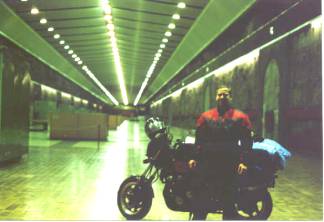 On
the way back to the HydroQuebec offices, my guide asked if I’d like to take my
bike into the powerhouse. It’s sort of
a tradition they do for cyclists who ride the James Bay Road. I had read a trip report by another cyclist
who did the same, but didn’t I really expect to be able to do it myself. Well, I was wrong. I hopped onto my bike, followed the minivan back to the huge
doors, down the long underground ramp, and into the powerhouse. I noticed a couple burnout marks on the tile
floor from past motorcycles.
Marie-Pierre snapped a picture of me with my bike, and we headed back
out. I followed the minivan back down
the road, and Marie-Pierre turned right into Radisson, while I continued
straight. Another mile down the road I
stopped to put in my earplugs and check the time. The tour lasted three full hours. It was one on one the whole time. Marie-Pierre had a very informative answer for every question
that came to mind. A truly amazing tour
that lasted three hours, and it didn’t cost me a cent! For anybody riding the James Bay Road, a
stop for a tour at the Robert-Bourassa generating facility in Radisson is a
must!
On
the way back to the HydroQuebec offices, my guide asked if I’d like to take my
bike into the powerhouse. It’s sort of
a tradition they do for cyclists who ride the James Bay Road. I had read a trip report by another cyclist
who did the same, but didn’t I really expect to be able to do it myself. Well, I was wrong. I hopped onto my bike, followed the minivan back to the huge
doors, down the long underground ramp, and into the powerhouse. I noticed a couple burnout marks on the tile
floor from past motorcycles.
Marie-Pierre snapped a picture of me with my bike, and we headed back
out. I followed the minivan back down
the road, and Marie-Pierre turned right into Radisson, while I continued
straight. Another mile down the road I
stopped to put in my earplugs and check the time. The tour lasted three full hours. It was one on one the whole time. Marie-Pierre had a very informative answer for every question
that came to mind. A truly amazing tour
that lasted three hours, and it didn’t cost me a cent! For anybody riding the James Bay Road, a
stop for a tour at the Robert-Bourassa generating facility in Radisson is a
must!
I zoomed down the road to Chisasibi.
About 30 kilometers outside Chisasibi I hit a Cree checkpoint. The signs said that vehicles were subject to
search. A friend of mine came through
here a number of years ago and they searched his car. Alcoholism is a big problem in these Cree towns, and the tribal
elders have declared them dry. If you
have alcohol they will confiscate it. I
had a couple beers in my saddlebag for camp at night, but they never searched
me. A fellow came out of the shack,
asked my name, took down my plate number, and handed me some maps of town. He showed me exactly how to get out to the
coast 10 miles past town.
I rode into Chisasibi, rode around town a bit, and parked at the community
center. Inside at a restaurant I
refilled my water bottle for soup that night and coffee in the morning. I went back out to the bike and fired it
back up. Fifteen kilometers on gravel
to the west and I ran out of road.
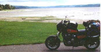
James Bay was in the way!
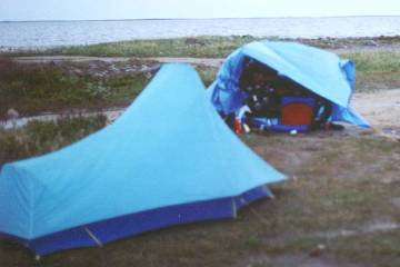 I
set up my tent and built a fire of driftwood.
It was pretty windy, so I slung my tarp over my bike and staked it out
like a lean-to so I could fire up my stove can cook dinner. In the wind it was cold and a little
rainy. But in the lee of my lean-to, it
was calm, I had my ThermaRest camp chair to sit on, my stove was cooking my
ramen noodles, I was munching on chips and cheese, and I was sipping a
beer. I had ridden 1308 miles in the
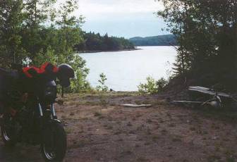
last three days, and I was camped on the shore of James Bay! My tent was set up and my dry sleeping bag
was inside. I had a nice fire
going. It was cold and rainy, but I was
comfortable and dry in my lean-to and riding suit. Some people find heaven on a Mexican beach sipping fruity drinks
in the sun. Not me. I was in heaven right there all alone on the
shore of James Bay next to my motorcycle.
My wife thinks I’m nuts. But if
you’re this far into this trip report, you can probably understand my feeling.
I
set up my tent and built a fire of driftwood.
It was pretty windy, so I slung my tarp over my bike and staked it out
like a lean-to so I could fire up my stove can cook dinner. In the wind it was cold and a little
rainy. But in the lee of my lean-to, it
was calm, I had my ThermaRest camp chair to sit on, my stove was cooking my
ramen noodles, I was munching on chips and cheese, and I was sipping a
beer. I had ridden 1308 miles in the
last three days, and I was camped on the shore of James Bay! My tent was set up and my dry sleeping bag
was inside. I had a nice fire
going. It was cold and rainy, but I was
comfortable and dry in my lean-to and riding suit. Some people find heaven on a Mexican beach sipping fruity drinks
in the sun. Not me. I was in heaven right there all alone on the
shore of James Bay next to my motorcycle.
My wife thinks I’m nuts. But if
you’re this far into this trip report, you can probably understand my feeling.
While I was sitting there, eating my dinner and sipping my beer, I was
contemplating just how pleasant it was.
While it was cold and windy right beyond my little shelter, I was quite
comfortable, and I was eating well.
Just then, two women walked up and said something to me in French. For the hundredth time since I entered
Quebec I smiled and said I didn’t speak French. One of them then asked in English, “Are you lost?” I quipped, “I’m as lost as I can get, but I
ran out of road.” One was a dentist
filling in for the regular dentist in Chisasibi while he was on vacation. The other was a swimming instructor in
Chisasibi for four months during the summer teaching the Cree kids how to
swim. We made small talk and one
mentioned that I must be cold and uncomfortable and she invited me back to her
hotel room for the night. Evidently the
months in Chisasibi had left her lonely for non-Indian companionship. Well, not only was I married, I was camped
on the shore of James Bay – a long-term goal.
The male in me was a little torn.
But the motorcyclist and camper in me stood firm. I pointed to my fire and said that was my
living room. I pointed to my tent and
said that was my bedroom. I pointed to
the pot of Raman noodles and showed them my kitchen. Plus, I was sealed inside a warm riding suit and was quite
comfortable. Yes, I had a little devil
on one shoulder and a little angel on the other, arguing. Eventually they left (the women, that is),
with the one telling me to look her up in town if I was going to be around for
another night.
I crawled into my tent at sunset – about 10:30. It rained most of the night, and it never got very dark.
Day 4: James Bay to south of Matagami - 536 miles
 When
I woke up, the sun was up and it wasn’t raining, but it looked like it could
soon. So I quickly made my coffee and
proceeded to pack up camp. I rode back
into Chisasibi, hoping to track down breakfast at a restaurant at the community
center. I rolled up to the place, but
it was closed. They opened at 8:00 and
I checked the watch in my tank bag to see how long I had to wait. It was 6:00. I decided two hours was too long to wait around for
breakfast. I was low on fuel in the
tank, but I had 2 ½ gallons on the back.
So I unstrapped the gas can and poured it into my tank. While I was doing this, two Cree teenagers
came walking by. They struck up a
conversation with me, impressed at how far I was away from home on a
motorcycle. We talked a bit while I
readied the bike. One of them asked me
if I wanted a shot, as he pulled a bottle of booze from his jacket and poured
some into the cans of soda he and his buddy were holding. Alcoholism and drug abuse are big problems
in these Cree communities. One wonders
what the North American Indian civilizations would be like had the White Man
never come along and screwed things up for them.
When
I woke up, the sun was up and it wasn’t raining, but it looked like it could
soon. So I quickly made my coffee and
proceeded to pack up camp. I rode back
into Chisasibi, hoping to track down breakfast at a restaurant at the community
center. I rolled up to the place, but
it was closed. They opened at 8:00 and
I checked the watch in my tank bag to see how long I had to wait. It was 6:00. I decided two hours was too long to wait around for
breakfast. I was low on fuel in the
tank, but I had 2 ½ gallons on the back.
So I unstrapped the gas can and poured it into my tank. While I was doing this, two Cree teenagers
came walking by. They struck up a
conversation with me, impressed at how far I was away from home on a
motorcycle. We talked a bit while I
readied the bike. One of them asked me
if I wanted a shot, as he pulled a bottle of booze from his jacket and poured
some into the cans of soda he and his buddy were holding. Alcoholism and drug abuse are big problems
in these Cree communities. One wonders
what the North American Indian civilizations would be like had the White Man
never come along and screwed things up for them.
I rode around Chisasibi a little, then headed back up the road toward
Radisson just as the rain started again.
A few miles beyond the Cree checkpoint, I took a short detour to the La
Grande 1 hydroelectric dam, and rode across the top of it. The road continued back to the coast on the
north side of the La Grande River, but I stopped just past the dam and turned
around. That bit of road will have to
wait for next time. And there will be a
next time.
An hour and a half later I was back in Radisson. I gassed up the bike, ate breakfast, and headed south. I paused for a few moments at the
intersection with the gravel Trans-Taiga Road.
This is gravel road heads 420 miles east-northeast along the La Grande
River drainage, and services the hydroelectric powerplants dotted along the
river. I drooled at the thought of
riding all the way to Lake Caniapiscau, but that would have been a couple days’
round trip, I was on a street bike with street tires, I was cold, and even with
the extra gas on the back of my bike I wouldn’t have been able to make it the
whole way, even with tanking up at the gas stop about half-way out. It would have to wait for next time. A couple more hours I was back at kilometer
381, frozen solid one more time. I
spent a couple hours there sucking down hot coffee and thawing out, before I
gassed up the bike and headed even further south. I kept my speed below 50 again for this longest of stretches
between gas stops.
About 60 miles south I found myself at the junction with the gravel North
Road to Chibougamau. It was rainy, I
was cold, and I was having some doubts about doing this 300 miles of
gravel. I started up the road
cautiously, testing the braking and steering.
After a half-mile or so, I decided it was a little too squirrelly, so I
wimped out and turned back to the pavement.
The last time I was on a long, lonely gravel road in northern Canada in
the rain I got a little horizontal and limped for weeks. I still wanted to go to Chibougamau, as that
would allow me to take a completely different route home, so I went via
Matagami and Amos.
I droned south on the pavement after this decision, keeping my speed below
50 to conserve fuel. I passed by some
construction where they were using heavy equipment to build a gravel road to
the west. A later peek at a map left me
thinking that this was a road being pushed out to Waskaganish, another Cree
village on James Bay currently unreachable by road.
After a couple hours I think I was becoming a little hypothermic, as I was
feeling dizzy and didn’t have the slightest need to shiver. I stopped and got off the bike. As soon as I started relaxing, I started
shivering uncontrollably. So I pulled
out my stove, and brewed myself a hot cup of coffee. It was a good time to dump the gas I had on the back of the bike
into the tank, too. As I got ready to
hit the road again, I decided I was close enough to pick up the speed
again. The rest of the way back to
Matagami was at super-legal speeds, and it got warmer the farther south I went.
Another gas stop in Matagami, and I was blasting down the road toward
Amos. I found another nice place to
camp south of Matagami a ways along a two-track that headed off into the woods.
Day 5: South of Matagami to Ashuapmushuan Provincial Preserve - 443 miles
The next morning after coffee, I continued on. I went through Amos, headed east to Senneterre, then turned north
toward Chibougamau. This was all
high-speed riding, most of the time between 75 and 85 mph. I took a short detour through Waswanipi,
another Cree village, and continued to Chibougamau. Once I reached Chibougamau. I had ridden about 600 miles since
that junction at the north end of the North Road the day before. By the gravel North Road it would have been
half that distance. But I’m certain
that my average speed on the pavement was more than double what I would have
done on the gravel. I’ll save that road
for the next time up there as well.
 I
headed south through the Ashuapmushuan preserve and took a short break at a
rest stop along the road. I took the opportunity
to wash my hair for the first time in five days in a small stream. Camp Suds are great! Back on the bike for a few more miles and I
found another nice place to camp, where I dined on steak, cheese, and bread,
all washed down with some Labatt’s Blue.
I
headed south through the Ashuapmushuan preserve and took a short break at a
rest stop along the road. I took the opportunity
to wash my hair for the first time in five days in a small stream. Camp Suds are great! Back on the bike for a few more miles and I
found another nice place to camp, where I dined on steak, cheese, and bread,
all washed down with some Labatt’s Blue.
Day 6: Ashuapmushuan Provincial Preserve to south of Prince Georges - 468
miles
 The
next morning I continued south toward Lac St. Jean. After a while the hills leveled out and I found myself whizzing
through farmland. I turned northeast at
St. Felicien and headed around the lake, where I stopped for breakfast in
Dolbeau. I was a little disappointed
with the area, as I expected the road to somewhat hug the shoreline. Most of the way around the lake and down the
north side of the Saguenay Fjord, I hardly knew there was a big body of water
to my right. Shortly beyond Chicoutimi,
the road headed over into a narrow valley parallel to the fjord and went
through some really nice twisties.
After a while I found myself in Tadoussac, where I stopped for a cup of
coffee and a donut before taking the ferry across the mouth of the Saguenay to
continue the ride down the north side of the St. Lawrence.
The
next morning I continued south toward Lac St. Jean. After a while the hills leveled out and I found myself whizzing
through farmland. I turned northeast at
St. Felicien and headed around the lake, where I stopped for breakfast in
Dolbeau. I was a little disappointed
with the area, as I expected the road to somewhat hug the shoreline. Most of the way around the lake and down the
north side of the Saguenay Fjord, I hardly knew there was a big body of water
to my right. Shortly beyond Chicoutimi,
the road headed over into a narrow valley parallel to the fjord and went
through some really nice twisties.
After a while I found myself in Tadoussac, where I stopped for a cup of
coffee and a donut before taking the ferry across the mouth of the Saguenay to
continue the ride down the north side of the St. Lawrence.
The road along the St. Lawrence winds in and out and up and down through the
hills, with many spectacular vistas of the seaway. After a while I made it to Quebec City and plunged straight into
the heart of the city. Feeling awfully
claustrophobic and out of place, I wound my way through downtown before I hit
the freeway on the other side. I
crossed the St. Lawrence and continued south to St. Georges, where I stopped at
a grocery store for another hunk of cow to cook in camp. There were only about 25 miles to the
border, so on the way out of town I stopped at a gas station, fished through my
pockets for the remainder of my Canadian money, and put that amount of gas into
my bike. About five miles short of the
US border I found a two-track that went a couple hundred yards into the forest,
where I set up camp for the night.
Day 7: South of Prince Georges to Kankamagus Highway - 421 miles
The next morning I hit the road and crossed back into the US. Fifteen miles down the road I stopped in
Jackman, Maine, for a breakfast of bacon and eggs before continuing on. A while later I stopped for gas and decided
I would ride over to Acadia National Park, so I wound my way eastward via a
bunch of little roads and caught I-95 at Pittsfield. A short zoom on this four-lane, and I headed east on Alt.1 to
Ellsworth. In Ellsworth I started
getting the impression that this might have been a mistake. Traffic was incredibly heavy, and it was
stop and go for miles. I pressed on
toward Bar Harbor anyway, since I had never seen the area.
Yep. Big mistake. Traffic was all jammed up at the entrance to
Acadia National Park. I decided I’d
ride into Bar Harbor first to check the place out. It was stop and go practically the whole way. There was traffic everywhere. People everywhere. It was incredible. It
took about 15 minutes to make a ‘quick’ loop through the downtown area. Sitting in the traffic there I decided I had
to get out and headed for the exit.
Forget Acadia. Judging by the
traffic jam I saw at the entrance to the park, it was probably more of the
same. I’ll check it out sometime when
there are fewer people. Perhaps I’ll
come back in the fall when the days are cool, the nights downright chilly, and
the bike is covered in a light coating of frost when I wake up in the
morning. I backtracked to Ellsworth,
still in pretty heavy traffic. Things
lightened up significantly as soon as I headed south on 1 from Ellsworth.
I settled into a decent cruise along this stretch of road. I passed by what almost looked like large
lakes, but the map told me they were arms of the Atlantic Ocean reaching into
the craggy coastline of Maine. I was
starting to check out possible camping sites along the way. It seems that every road or two-track had a
house or farm along it. The population
density was pretty high, and it was difficult to find a suitable campsite (this
early in the afternoon I’m picky).
After a couple hours of evaluating the sides of the road for
possibilities, I decided that along highway 1 I just wasn’t going to find
it. I pulled into a parking lot in
Camden and pulled out my map.
The Kamkamagus Highway in the White Mountain National Forest looked
inviting. I had been up there a couple
years ago and there was plenty of camping.
It was a couple hours away, and not too far out of my way back
home. I plotted my course, folded up my
map, and turned west. The sun was thinking
about heading for the western horizon, so I picked up my pace. I zipped to Augusta, hopped onto the tollway
to Lewiston, then headed for highway 302 to Conway, NH, the whole time watching
the sun sink lower toward the White Mountains.
When I pulled into Conway, I tracked down a package store and picked up a
six-pack of Red Rack Ale, something brewed by some microbrewery for the
Woodstock Inn in Woodstock, NH. When I
travel and get beer for the night in camp, I usually look for something
local. You can get Bud or Labatts just
about anywhere (provided that’s what you’re into), but some of these no-name
brews can only be had in no-name places, and some of them are pretty
tasty. I tucked the bottles into my saddlebags
then hit the road.
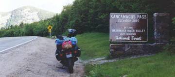
A short distance out of town I turned right onto the Kankamagus Highway,
which heads up and over the White Mountains.
A few hundred yards up this road I spotted a sign saying ‘No camping
along this road’. I figured that by
‘along this road’ they meant on the shoulders and in the pullouts. Yep, who’d want to camp in a place like
that?
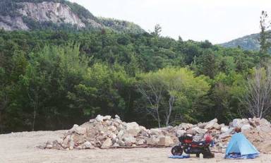 A
couple miles up I spotted a gated road heading off into the woods. I parked the bike and scouted a little
bit. It would be tough to get the bike
around the gate, so I pressed on. A
little further I saw a similar gated road with a similar difficulty in getting
the bike around the gate. The third one
I checked out had a really nice path to get the bike around the gate, and after
a short distance opened to a large gravel area with a pile of boulders near one
end. I parked the bike near the
boulders and evaluated the situation. I
was out of sight of the road. What’s
more, I could build a huge roaring fire behind the boulders and it wouldn’t be
visible from the road even in the dark of night. I set up my tent, collected a bunch of firewood, and cooked a
dinner of Ramen noodles and chicken chunks.
A
couple miles up I spotted a gated road heading off into the woods. I parked the bike and scouted a little
bit. It would be tough to get the bike
around the gate, so I pressed on. A
little further I saw a similar gated road with a similar difficulty in getting
the bike around the gate. The third one
I checked out had a really nice path to get the bike around the gate, and after
a short distance opened to a large gravel area with a pile of boulders near one
end. I parked the bike near the
boulders and evaluated the situation. I
was out of sight of the road. What’s
more, I could build a huge roaring fire behind the boulders and it wouldn’t be
visible from the road even in the dark of night. I set up my tent, collected a bunch of firewood, and cooked a
dinner of Ramen noodles and chicken chunks.
I lit up the campfire and watched the sun dip below the mountains to my
west. I sipped my ale and took in the
surroundings. It’s been a good
ride. I camped on James Bay. I rode a bunch of remote roads in
Quebec. I took the ferry across the
Saguenay Fjord. I rode along the St. Lawrence and through the woods of
Maine. My little Nighthawk has treated
me well for 11 years now. It’s taken me
to the west, east, and north coasts of North America without missing a beat, so
I gave it a little toast. After a
couple beers the fire was starting to burn low, so I crawled into my tent and
got some snores.
Day 8: Kankamagus Highway, NH to South Windsor, CT - 231 miles
One more time, I crawled out of the tent and partook in the daily coffee
ritual. I took my time breaking camp,
knowing that it was a pretty short ride today.
Once I had everything on the bike, I hit the starter button and the
engine jumped right to life. It’s hard
to describe, but there’s something special about starting your bike first thing
in the morning after a good night of camping.
It was a beautiful day, the bike was running well, and nice roads were
in my immediate future -- everything that makes motorcycle camping such a
profoundly enjoyable experience.
 I
got back onto the pavement and continued up the Kank. It was early in the morning so there was little traffic. As opposed to the night before, I now had
the sun to my back. After a couple
miles I was able to take the choke off completely and get into the
twisties. The pace picked up. Life is good. I made maybe two or three creative interpretations of the double
yellow on the way up to the pass, and encountered no traffic in the way down
the other side. After a short time I
rolled into Lincoln and tracked down breakfast.
I
got back onto the pavement and continued up the Kank. It was early in the morning so there was little traffic. As opposed to the night before, I now had
the sun to my back. After a couple
miles I was able to take the choke off completely and get into the
twisties. The pace picked up. Life is good. I made maybe two or three creative interpretations of the double
yellow on the way up to the pass, and encountered no traffic in the way down
the other side. After a short time I
rolled into Lincoln and tracked down breakfast.
After breakfast, I continued on westward.
A short distance down the road I passed through Woodstock, so I took a
short detour to see the inn that last night’s Red Rack Ale was brewed for. These New England Inns are probably pretty
nice inside. But I’d rather be sipping
their ales around a campfire under the stars.
I turned south on 118, then followed 25 and 25A over to 10, riding lots of
really good twisties the whole way. I
turned south on 10 and rode it to Hanover, where Dartmouth College is. After a quick turn through Hanover to check
the place out, I decided it was time to head for home. So I crossed the river, hopped onto I-91,
and settled into one last drone southbound toward home, family, and work.
The 420-mile Trans-Taiga Road from just south of Radisson out to Lake
Caniapiscau still beckons me, as do the gravel road to James Bay on the north
side of the La Grande River and the North Road between Nemascau and
Chibougamau. Those are still just squiggly
lines on a map to me, but the James Bay Road is no longer. It’s a long paved road snaking through
remote wilderness. And I’ve camped on
the shore of James Bay. Been there,
done that. And I’ll do it again as soon
as I can arrange it.

 When
I hit Mont Laurier I picked up a sub sandwich, filled up with gas (including
the 2 ½ gallon can I had strapped to the homemade bracket mounted over my tailpiece
– built specially for the Dempster Highway, but finding new life on this trip)
and continued northwest into the La Verendrye Provincial Preserve.
When
I hit Mont Laurier I picked up a sub sandwich, filled up with gas (including
the 2 ½ gallon can I had strapped to the homemade bracket mounted over my tailpiece
– built specially for the Dempster Highway, but finding new life on this trip)
and continued northwest into the La Verendrye Provincial Preserve.