BALLINTOTAS NATIONAL SCHOOL
Local History
BALLINTOTAS CASTLE
A Geraldine Castle which was marked on Batiste Boazio's map of 1598.
BALLINTOTAS NATIONAL SCHOOL
Local History
BALLINTOTAS CASTLE
A Geraldine Castle which was marked on Batiste Boazio's map of 1598.
The building has three storeys and one entrance door in the western side.
It measures 21 feet 6 inches in length by 20 feet 6 inches in width and its height is approximately 50 feet
CASTLEFIELD
It was originally part of the estate of the Earl of Shannon.
In the 1920's & 1930's it was used as a meeting place after Sunday Mass.
Many activities such as hurling football, tug o'war, pitching horseshoes and pitch and toss were played there.
BALLINTOTAS SCHOOL 1825
This school was built on Church grounds near the castle and was paid for out of parish funds. The walls were stone and mortar and the roof was thatched. It consisted of one room measuring 50 feet 4 inches in length and 13 feet 8 inches in width. It was furnished with one large desk, one small desk and seven large forms.
It could accommodate eighty pupils. Classes were held six days a week from 9 am to 4 p.m. and religious instruction classes were held on Sundays from 9 a.m. - 12 noon, except during Mass which was held in the Church here near the castle.
An Inspectors observations and suggestion book from 1856 onwards until its closure in 1898 has survived. It gives an account of the District Inspectors reports when he visited the school on a twice yearly basis reporting on:
(I) Each Class
(ii) Mode of Teaching
(iii) Discipline and Order
(iv) School Accounts
(v) School room & Premises
(vi) Supply of Books & Apparatus
(vii) Industrial Training
(viii) Observance of former suggestions.
The final Inspectors report for this school dated 31st March 1998 in which the building was described as a 'wretched hovel'.
OLD CATHOLIC CHURCH
One wall of the church is still standing near the western side of the castle.
There is reference made to this church in the report of Bishop Matthew McKenna of Cloyne in 1785. The church was attached to the Parish of Ballyoughtra at that time.
The Church was interdicted by Bishop Coppinger in 1799, because the local people put up a notice near the church refusing to pay tithes, however the matter was resolved and Mass resumed the following Sunday.
This Church was used until the new church of St. Colman was built in 1842.
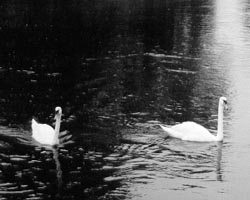
LOUGHADERRA LAKE (Midleton East Cork)
Features of Loughaderra
The lake is approximately 30 acres in area and the average depth is between 4 and 5 feet. There area a number of shallow passages, paved by limestone, running across the lake. These were used in the last century by people travelling by horse and car.
There is no over-ground inlet to Loughaderra. It is fed by underground springs and it is suggested that the river which flows out of the rock at Dower, Ladysbridge is connected by underground passages to Loughaderra.
The lake had been prone to flooding unto the Cork-Youghal road but this problem was alleviated in the 1960's when the drain connecting it to Ballybutler Lake was improved.
The weather in 1939 was extremely harsh and the lake was used as a skating rink and remained frozen for several weeks. People from far and near came to walk and skate across it. A ford prefect car was driven across it, as was a Honda and several boys cycled across. The lake has frozen many times since but not to the extent of 1939.
Fishing
The lake is 16 miles east from Cork City, adjoining the Cork to Youghal N 25 road. Adult Rainbow Trout are stocked regularly to maintain a high stock density and give worthwhile angling returns. The lake also holds a large stock of small Rudd and Eels - Rudd forming an important part of the Trout's diet. Some attractive shore angling sites and six boats are available for hire, but should be booked well in advance due to demand.
Folklore
There is an abundance of local folklore regarding the origin of the Lake called Loughaderra.
The following are three different versions and you can decide which is the most acceptable (or colourful) version.
The Peat Bog that Flooded
The basin of the lake consists of white marl, an impervious foundation for a layer of peat. In former days this peat was cut away the people of the area for fuel. The excavating continued uniformly over the whole extent of the basin until wit was discovered that while elsewhere the peat was becoming inferior the corner nearest to the church (Ballintotas) was yielding peat of fine quality. A dispute then arose regarding the good peat, and it was referred to the local Druid who decided that all had an equal right to the good peat. At this corner of the bog therefore the peat cutting was intensified, and in a short time the depth was much greater than else where. still the people dug and it then became noticeable that the latest cut peat was showing a greater moisture content.
When, one morning, the people came as usual to cut their peat needs, they found a pool of water, where on the previous evening they were extracting good peat forty feet below the general level of the whole area, and in a few days Loughaderra as it appears today had been formed. Examination showed that the weakened turf seat on the marl underlay had given way, and an underground pressure stream or spring had flown upwards and filled the deeper level. Gradually the pressure from below released greater volumes until the water covered the whole extent of the digging operations.
St. Colman's Site
St. Colman is the Patron Saint of this area and his name is now recorded in the Churches, Cathedral and Schools of this Diocese. St. Colman travelled Ireland extensively in the 6th century spreading the faith and establishing Churches as he went.
The Loughaderra area was a picturesque plot of farmland at that time and St. Colman was immediately struck by it as an ideal location for a church. He requested a site from the local chieftain but was refused immediately. That night there was a most violent storm, which flooded all of the Loughaderraa area with the exception of the site of the present Church. The Chieftain, fearing that the rest of his land would also be submerged, sent for St. Colman and gave him the site which was not flooded and this has been the location for the Church ever since.
The Wood that Vanished
The area where the lake is now located was once covered by a dense, dark oak wood. It was part of the estate of an Elizabethan Seneschal of Imokilly who resided in, and ruled from the Castle of Castlemartyr nearby.
On one occasion after a Geraldine incursion the Seneschal, suspecting local co-operation with the invaders, collected a large number of residents in the immediate locality and, after a hasty and summary starchamber accusation pronounced all guilty. Not one of the accused persons was ever after seen alive or dead, and the grim details of a mass execution in the deep, dark oak-wood eventually became known. From that day the place was regarded as cursed, and within a year blight robbed the oaks of growth and leaf. Then during a winter night of howling, withering storm, devastation fell on Loughaderra, and when the daylight came no trace of tree or wood remained - only a wide expanse of gurgling, angry waters covering the place where they grew. Old inhabitants will tell you today that for long years after the naked treetops could still be seen on clear days far down in the lake's depths.