THE DEATH OF THE DINOSAURS, SUPERFLOODS
AND OTHER MEGACATASTROPHES:
CATASTROPHES AND SCIENTIFIC CHANGE
Based on an invited lecture at Auburn University, Auburn, AL, 11 May 1998
COPYRIGHT 1998 BY EMERSON THOMAS MCMULLEN
Introduction
A Gary Larson "far side" cartoon about the death of the dinosaurs has a
stegosaurus saying "the future is pretty bleak, gentlemen. . . the world's climates are
changing, the mammals are taking over, and we all have a brain about the size of a
walnut." These are three theories for dinosaur extinction: three ideas about nature.
Formulating ideas about nature and testing them is one facet of science. Testing
theories involves gathering relevant data, and this gathering of data about nature is the other facet of science.
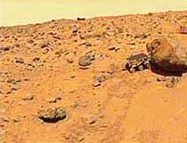 It's job was to explore Ares Vallis and gather data about Mars. Scientists picked
this spot because it looks like an outflow channel that was formed by a catastrophic
flood. Therefore they expected to find many different kinds of rocks in the valley.
The reason they think there was a flood is due to the valley's similarity to features in
the Channeled Scablands of Washington State.
It's job was to explore Ares Vallis and gather data about Mars. Scientists picked
this spot because it looks like an outflow channel that was formed by a catastrophic
flood. Therefore they expected to find many different kinds of rocks in the valley.
The reason they think there was a flood is due to the valley's similarity to features in
the Channeled Scablands of Washington State.
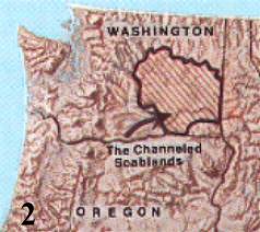
Two years before the pathfinder landed on Mars, you could find an
announcement on the Internet for a NASA-funded landing site workshop in
Spokane, Washington, my hometown. The workshop was for all interested scientists and included
overflights and surface investigations of the Channeled Scablands. The scablands
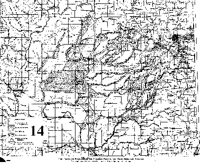
(figure 2) are located in eastern Washington and are roughly bounded by the
Spokane, Columbia, and Snake Rivers. The reason for studying the scablands is
 that they were formed by a superflood. Therefore scientists could gain a better
understanding not just of Ares Vallis but of many other similar Martian features that
seem to have been caused by catastrophic flows.
that they were formed by a superflood. Therefore scientists could gain a better
understanding not just of Ares Vallis but of many other similar Martian features that
seem to have been caused by catastrophic flows.
The Channeled Scablands
You may have heard about the Channeled Scablands because there was a
geological controversy about how they were formed. I first heard about them 40
years ago when the controversy was at a peak. I was president of the science club
at Lewis and Clark High School in Spokane, Washington, because I thought science
 had all the answers. In the 1950's, a guest speaker at a club meeting told us about
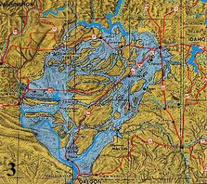
the scablands controversy. It starts with J Harlan Bretz, a PhD geologist at the
University of Chicago who, after extensive field work on the scablands, he
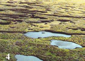
concluded in 1922 that they were caused by a gigantic, catastrophic flood (figure 3).
He calculated that 3000 square miles were swept by a superflood, which at points
may have been up to 1,000 feet deep. More than 2,000 square miles were scrubbed
bare, forming the scablands, as in figure 4. Nearly 1,000 square miles of the scablands contain gravel deposits from the eroded basalt. Later calculations indicated
that it all happened within 30 days.
had all the answers. In the 1950's, a guest speaker at a club meeting told us about
the scablands controversy. It starts with J Harlan Bretz, a PhD geologist at the
University of Chicago who, after extensive field work on the scablands, he
concluded in 1922 that they were caused by a gigantic, catastrophic flood (figure 3).
He calculated that 3000 square miles were swept by a superflood, which at points
may have been up to 1,000 feet deep. More than 2,000 square miles were scrubbed
bare, forming the scablands, as in figure 4. Nearly 1,000 square miles of the scablands contain gravel deposits from the eroded basalt. Later calculations indicated
that it all happened within 30 days.
The most interesting scablands feature is Grand Coulee. In the late 1940's and
early 1950's, various relatives from the east made a series of visits to my family.
We always took them to one of the engineering wonders of the time - Grand Coulee
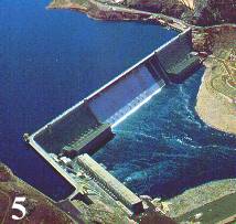 Dam (figure 5). When we traveled south from the dam, we would see upper Grand
Coulee. It is a channel carved right through solid basalt, some of it down to the
underlying granite. Grand Coulee Dam is built on some of that granite.
Dam (figure 5). When we traveled south from the dam, we would see upper Grand
Coulee. It is a channel carved right through solid basalt, some of it down to the
underlying granite. Grand Coulee Dam is built on some of that granite.
Figure 6 is an early aerial shot of upper Grand Coulee. Bretz said it is the best
example of water forming a canyon in the world.(1)
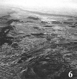
It is 50 miles long and several miles across. In the foreground is Electric City. You can see the steep sides of the
channel as it fades out of sight toward the southwest. If this canyon had been
formed by the standard erosional processes that we observe today, it would be a v- or u-shaped
valley. Of course, it is not, so perhaps it was not formed by present-day processes,
but by something not in our immediate experience. This is what Bretz thought. In
the upper left is a large formation, Steamboat Rock, again with very steep sides,
 sticking up out of the middle of the Coulee. Later, Dry Falls Dam eventually formed
Banks Lake which filled Grand Coulee, as seen in figure 7. Steamboat Rock still
stands out and you can still see the steep sides of the canyon as it continues
southwest toward Dry Falls.
sticking up out of the middle of the Coulee. Later, Dry Falls Dam eventually formed
Banks Lake which filled Grand Coulee, as seen in figure 7. Steamboat Rock still
stands out and you can still see the steep sides of the canyon as it continues
southwest toward Dry Falls.
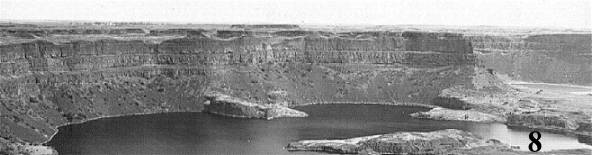
At the end of upper Grand Coulee is Dry Falls, another massive geological
feature that impressed me as a youngster. Figure 8 views the face of the falls from a
vantage point at the western side of the falls. (My late mother took this shot
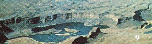 sometime in the early 1950's.) Figure 9 is an aerial view looking in a northerly
direction - a flood of water came out of upper Grand Coulee and poured over Dry
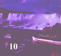
Falls. It is 350 to 400 feet high and over 3 miles long. Dry Falls is almost five
times the width of Niagara Falls (figure 10) and over twice as high. What must the
sometime in the early 1950's.) Figure 9 is an aerial view looking in a northerly
direction - a flood of water came out of upper Grand Coulee and poured over Dry
Falls. It is 350 to 400 feet high and over 3 miles long. Dry Falls is almost five
times the width of Niagara Falls (figure 10) and over twice as high. What must the
 falls have looked like with its full volume of water thundering over it? It probably
shook the ground for miles around. Even though it is in arid country, Bretz had no
doubt that this was once a gigantic waterfall. As seen in figure 11, there are
falls have looked like with its full volume of water thundering over it? It probably
shook the ground for miles around. Even though it is in arid country, Bretz had no
doubt that this was once a gigantic waterfall. As seen in figure 11, there are
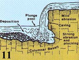 evidences of plunge pools, undercutting, and cataract retreat.
Bretz observed and studied many other formations, most of which indicated a
superflood. One is Palouse Canyon, again, cut through solid basalt. Several of
these canyons had cataracts at their heads and/or hanging valleys. Bretz also
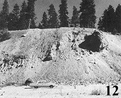 reported many massive flood deposits like the one in figure 12, near Coeur d'Alene,
Idaho. The car in the picture gives you an idea of the immense size of the deposit.
Some deposits contained boulders 3 to 4 feet in diameter. Quincy Basin, in the
western part of the scablands, has huge amounts of gravel: the gravel covers 500
reported many massive flood deposits like the one in figure 12, near Coeur d'Alene,
Idaho. The car in the picture gives you an idea of the immense size of the deposit.
Some deposits contained boulders 3 to 4 feet in diameter. Quincy Basin, in the
western part of the scablands, has huge amounts of gravel: the gravel covers 500
 square miles, at a depth of at least 125 feet. At its peak, water from the superflood
flowed at a rate greater than the combined flow of all the rivers of the world today.
square miles, at a depth of at least 125 feet. At its peak, water from the superflood
flowed at a rate greater than the combined flow of all the rivers of the world today.
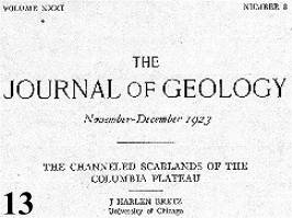
Bretz published several papers on the scablands. His 1923 paper from the
Journal of Geology (figure 13), contains a sketch of the scablands. Bounding a
 region of approximately 3,000 square miles (figure 14), the shaded area is the
square 2,000 miles of this region that was Channeled and scrubbed by this vast
amount of water. The cross-hatched area represents the 1,000 square miles of
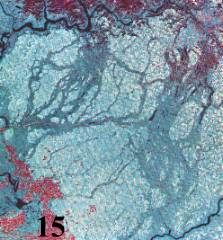
gravel deposits. Figure 15 is a 1972 satellite infrared picture of the scablands. The
dark braided areas are the channel ways of the superflood. Comparing this to the
previous figure, we can see that basically, Bretz got it right. This shows how good a
job Bretz did, especially considering he did all his work from the ground.
region of approximately 3,000 square miles (figure 14), the shaded area is the
square 2,000 miles of this region that was Channeled and scrubbed by this vast
amount of water. The cross-hatched area represents the 1,000 square miles of
gravel deposits. Figure 15 is a 1972 satellite infrared picture of the scablands. The
dark braided areas are the channel ways of the superflood. Comparing this to the
previous figure, we can see that basically, Bretz got it right. This shows how good a
job Bretz did, especially considering he did all his work from the ground.
Bretz' contention that a superflood caused the Channeled Scablands seemed to
blow the minds of his fellow geologists. He had made one traverse of 1,000 miles
over the scablands and later, another of 2,000 miles, but it made no difference to
them; no one backed his theory. Furthermore, he received a lot of resistance,
especially from the U.S. Geological Survey. He confronted these geologists at a
1927 meeting of the geological society of Washington, D.C., where he was on the
program. The next week he wrote to a friend who was teaching at my high school.
He said "they were all loaded for me and after letting me talk for two hours they
opened fire."
What these esteemed geologists said followed strictly uniformitarian dogma. In
general, uniformitarianism argues that changes in the past happened as we see
change occur today. Thus change in the past had to have happened slowly and
weakly, often over a long period of time. I call uniformitarianism a guiding idea, or
an overriding assumption. Here are some of the remarks made by Bretz' critics; they
show uniformitarianism in action:
1. J. Gilluly: an equally plausible case for slow and steady change is reason enough
to reject catastrophic flooding. "The actual floods involved at that time were of the
order of magnitude of the present Columbia's, or at most, maybe a few times larger."
2. W.C. Alden: ". . . longer time and repeated floods could be allotted to do the
work."
3. E.T. McKnight invoked ". . . normal channel deposits of the Columbia. . ." as it
shifted around from time to time over preglacial, glacial, and post-glacial times.
4. G.R. Mansfield thought the scablands were ". . . better explained as the effects of
persistent ponding and overflow of marginal glacial water. . ." which changed their
positions and places of outlet from time to time, through a somewhat protracted
period.
5. Q.E. Meinzer said that ". . . every effort should be made to account for the
existing features without employing so violent an assumption. . . ."
They basically argued that normal flooding caused a pile of rock and gravel as
shown in figure 12, with boulders 3 to 4 feet in diameter. It doesn't take much of a
geologist to know that normal flooding, even over long periods of time cannot
produce the effect you see there, especially the big boulders.
Bretz summed it up: "uniformitarian-minded geologists were shocked." But Bretz
did not quit. One criticism was that he had an unconvincing source for his
superflood, which was glacial melt. So in 1930 Bretz published a paper suggesting
Lake Missoula. This was a gigantic lake formed in Montana by melting glaciers
that had subsequently emptied out. As seen in figure 16, the shoreline of this
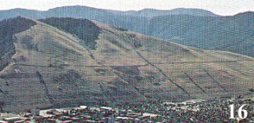 once-massive lake was first observed on sentinel mountain above Missoula in 1878.
Later J.T. Pardee wrote about it in 1910. Even though Bretz now had a better
source, critics still worked against him. The most heralded alternative to Bretz' idea
was that of R.F. Flint who, in 1938, used very selective field data and a
carefully-worded argument to try to undercut Bretz.
once-massive lake was first observed on sentinel mountain above Missoula in 1878.
Later J.T. Pardee wrote about it in 1910. Even though Bretz now had a better
source, critics still worked against him. The most heralded alternative to Bretz' idea
was that of R.F. Flint who, in 1938, used very selective field data and a
carefully-worded argument to try to undercut Bretz.
Then Pardee discovered giant ripple marks in the early 1940's (figure 17). They
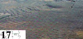 are 20 to 30 feet high and from 200 to 300 feet apart. This find indicated that there
had been a huge flow of water out of Lake Missoula, as Bretz had predicted.
Pardee published it all in 1943. Still, some geologists remained unconvinced, so
Bretz made his last scablands field trip in 1952.
are 20 to 30 feet high and from 200 to 300 feet apart. This find indicated that there
had been a huge flow of water out of Lake Missoula, as Bretz had predicted.
Pardee published it all in 1943. Still, some geologists remained unconvinced, so
Bretz made his last scablands field trip in 1952.
He found even more giant ripple marks from the superflood. He published a
detailed account of these while rebutting his critics and undermining rival theories.
Finally, years later, after a well-attended 1965 field trip to the scablands, most geologists
accepted Bretz' superflood. It took over four decades, but yesterday's heresy had
become today's orthodoxy.
Why did it take so long for these scientists to come around? Bretz' theory was
falsifiable, had plenty of evidence to support it, explained the data better than any
other theory, and made correct predictions. What more could be asked of a
scientific theory? So why the resistance and the big delay in acceptance? A reason
that Harvard professor Stephen J. Gould and others have given is the unhealthy
influence of the uniformitarian assumption, but that is not the whole story.
Bretz was especially frustrated that many of his opponents had not even viewed
the scablands, and those who had traveled there only saw part of them. We are
talking about intelligent, highly-educated geologists, so how could they even think
about rejecting a well-researched theory about the scablands without even going out
to see them?
A better reason for their out-of-hand dismissal of Bretz' idea is ideological. Let
me explain why by giving some historical background.
Cuvier
At the end of the 1700's and the beginning of the 1800's, one of the world's
foremost scientists was Georges Cuvier (1769-1832). He is famous for making the breakthrough
on extinctions - that there are animals which had lived in the past, but no longer live today.
His brilliant studies of fossil quadrupeds had caused him to think that there may have been sudden geological
changes in the earth's history (figure 18).
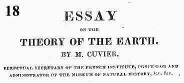
From the results of his studies, and from the researches of others, Cuvier
concluded that the sea had inundated the dry land several times. The majority of
these were "cataclysmic." They had a suddenness and an intensity not observed
today. Cuvier's proofs of these cataclysms were the "dislocations, siftings and
overturnings of the older strata", "the accumulations of debris", and "rounded
pebbles which in many places lie between solid beds of rock." His last catastrophe
involved animals, including Siberian mammoths, "encased in ice and preserved with
their skin, hair, and flesh down to our times."(2)
Mammoths
Much was known about these mammoths because of their prized ivory tusks
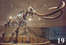 (figure 19). Cuvier enumerated in detail the places in Germany, France, Italy, and
other locations where mammoth bones or tusks had been found. An interesting early
find was in 1661 when Otto von Guericke witnessed the discovery of elephant
bones, along with enormous tusks, in limestone containing sea shells. Another was
a 1700 discovery of a mass burial of elephants near the city of Constadt.
(figure 19). Cuvier enumerated in detail the places in Germany, France, Italy, and
other locations where mammoth bones or tusks had been found. An interesting early
find was in 1661 when Otto von Guericke witnessed the discovery of elephant
bones, along with enormous tusks, in limestone containing sea shells. Another was
a 1700 discovery of a mass burial of elephants near the city of Constadt.
Cuvier also listed finds of mammoth bones and tusks in Russia. The whole of
Siberia had been mined for centuries for its fossil ivory. One island in particular,
was visited by fishermen's barges in the summer, and by dog sleds in the winter.
These convoys would return with mammoth tusks, each weighing 150-200 pounds.
In 1809, 10,000 pounds of fossil ivory were taken and production rose to 20,000
pounds in 1821.(3)
As fossil graveyards go, this island was just one particularly rich
vein in the Siberian mother lode. From about the 1300's onwards, this area supplied
the ivory demands of China, and from the 1700's on, also Met European demand.
This had to represent a huge number of preserved animals. For example: in the last decades of
the 19th century, 20,000 pairs of tusks in perfect condition were exported for the
ivory trade.(4)
It is hard to know exactly how many animals we are talking about, but
according to a recent estimate, there may be around 3 million mammoths still buried
in Siberia.(5)
So how did all these animals die? Especially known to Cuvier was the frozen
mammoth found near the mouth of the Lena River in 1799. Seven years later, a
botanist, Adams, on tour in Siberia, retrieved it for the Russian Academy of
Sciences. By that time, most of it had thawed and much of the animal's flesh had
been eaten by dogs, polar bears, wolves, wolverines, and foxes. About all that
remained were a frozen foreleg, some hair and wool, and the bones. The Adams
mammoth, an earlier frozen woolly rhinoceros, the large supply of fossil ivory for
export, and other evidences, convinced Cuvier that the megacatastrophe that befell
the mammoths and other Pleistocene animals was sudden and intense.(6)
While Cuvier was learning about these things, James Hutton and John Playfair
were promoting the uniformitarian idea that past geological processes and forces
were the same as those we observe today.
Cuvier was unconvinced - what process today rapidly buries and then freezes
large animals so quickly that their thawed flesh is edible? If they freeze slowly,
Cuvier wrote, they would putrefy to the extent that their flesh would be entirely
unedible. Also, sea shells were found with some mammoths. So While Hutton and
Playfair were arguing for their idea, Cuvier not only was accumulating evidence that
confirmed his theory, but also data that falsified their assumption.
Further, the researches of other naturalists supported Cuvier's position. Note that
Cuvier was not arguing on theological or ideological grounds. Cuvier never said
that the last of his series of megacatastrophes was Noah's Flood. Nevertheless,
some scientists such as Jean-Andre de Luc did.
In spite of much evidence of megacatastrophes, Charles Lyell, a lawyer who had
taken up geology, successfully championed Hutton's and Playfair's approach. With
skillful, lawyerly arguments, he eventually convinced naturalists that using the
uniformitarian assumption was the scientific way to view earth history. However,
he had no answer as to what process froze large Pleistocene animals such as the
Siberian mammoths and wooly rhinos. So he ignored the evidence. The strength of
Lyell's uniformitarian assumption and its attraction was, and is, ideological - it
automatically eliminated Noah's Flood and appealed to naturalism, a view many
found, and still find, attractive.
An early Lyellian convert was Charles Darwin, who not only accepted the
uniformitarian assumption, but also applied it to biology.
Late in the nineteenth century, Sir Henry Howorth continued the argument for
catastrophism, often citing the extinction of mammoths (figure 20). He wrote
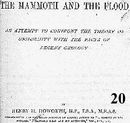 Darwin, asking him to explain the mammoths' demise. Darwin replied that for him
it was an insoluble problem. That is, it was "insoluble" for the theory Darwin was
proposing. As with Lyell, the strength of the uniformitarian assumption was not so
much its explanatory power as was its appeal to naturalism.(7)
Darwin, asking him to explain the mammoths' demise. Darwin replied that for him
it was an insoluble problem. That is, it was "insoluble" for the theory Darwin was
proposing. As with Lyell, the strength of the uniformitarian assumption was not so
much its explanatory power as was its appeal to naturalism.(7)
For better or for worse, uniformitarianism, often with an associated naturalism, came to dominate the
thinking of most scientists.
Price
For the first half of the twentieth century, an implacable foe of the uniformitarian
assumption was George McCready Price (1870 - 1962). Price was an intelligent
self-taught geologist, and an excellent and prolific writer. A strong Christian, he
opposed uniformitarianism on a Biblical basis, but he also wanted to prove his case
on scientific grounds. He marshaled huge amounts of evidence against the
uniformitarian view. I think that Price's adversarial role against uniformitarian
geologists indirectly caused so much trouble for Bretz' catastrophic scabland
explanation.
Price thought uniformitarianism was an unwarranted assumption. In 1906 he
wrote illogical geology which, among other things, provided still more information
on the Frozen Siberian mammoths. Price also reported new but similar
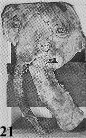 findings in Alaska (figure 21). Investigators had found vast tangled masses of bones, flesh, and
trees mixed together in the Alaskan muck, frozen before they could decompose.
These were the remains of numerous herds of animals, obviously killed in their
prime by a megacatastrophe. Price agreed with Howorth that the frozen mammoths,
edible when thawed, could only have been killed by a catastrophic event.
findings in Alaska (figure 21). Investigators had found vast tangled masses of bones, flesh, and
trees mixed together in the Alaskan muck, frozen before they could decompose.
These were the remains of numerous herds of animals, obviously killed in their
prime by a megacatastrophe. Price agreed with Howorth that the frozen mammoths,
edible when thawed, could only have been killed by a catastrophic event.
Price continued his assault, producing a huge number of books, tracts, and
articles for the next fifty years.(8)
In 1922, the year before Bretz first proposed a
cataclysmic origin for the scablands, Price Published God's Two Books: Or, Plain
Facts about Evolution, Geology, and the Bible. That same year Price also criticized
geological dating methodology in the Fossils as Age-markers in Geology. In 1923,
Price authored a textbook, The New Geology, and in 1924, The Phantom of Organic
Evolution. (A respected historian of science, Ron Numbers, edited some of Price's
works recently.)(9)
1925 was the year of the Scopes Trial. William Jennings Bryan wanted Price to
testify, but Price was in Europe, receiving an award from the Victoria Institute for
the best paper published in its proceedings.(10)
That same year Advent-Verlag in
Hamburg published a German-language work by Price. So Price had an
international impact.
In 1926, the year before Bretz confronted his critics in the U.S. Geological
Survey, Price published Evolutionary Geology and the New Catastrophism.
The uniformitarian geologists of the U. S. Geological survey did not want to put
their stamp of approval on Bretz' research for fear of handing Price more
ammunition. De luc had used Cuvier's investigations to argue for Noah's Flood, and
they did not want Price to do the same with Bretz' research. This is the best reason
as to why respected scientists dismissed a fellow-geologist's well-supported theory
on the scablands without even going to see the scablands themselves. Perhaps it was coincidence, but it was only
after Price died that they went to the scablands and agreed with Bretz. We will see
that the same type of resistance occurred when we examine how the dinosaurs died.
Dinosaurs
The extinctions we have been talking about so far occurred in the Pleistocene
Period, but just as fascinating are the dinosaur extinctions at the end of the
Cretaceous Period. There have been a tremendous number of speculations over the
last 150 years as to why these seemingly well-adapted animals died out. The
reasons vary from plagues to plant poisoning. A 1958 publication from Dinosaur
Quarry in Utah presents many of the extinction ideas current at that time (figure 22).
 The authors conclude their discussion by saying that the bottom line is we just don't
know.
The authors conclude their discussion by saying that the bottom line is we just don't
know.
The situation on dinosaur extinction changed in the late 1970's when a geologist,
Walter Alvarez, found an anomalous amount of iridium in a thin layer of clay at the
end of the cretaceous period. His father Luis, a physicist, had become involved. He
suggested that the extra iridium came from an asteroid impact that also happened to
be large enough to kill off the dinosaurs catastrophically. (There is more iridium in asteroids
than in the earth's crust. Even though the editor of
Science complained that there were too many papers already on dinosaur extinction,
he did publish their revolutionary paper in 1980. One reason the editor of Science
published it is the Alvarez's had evidence backing their theory. Another reason is
that Luis Alvarez had a Nobel Prize.
You would think that in a field littered with speculative ideas backed by little
evidence, scientists would welcome a theory based on some hard data. Such was
not the case. Instead, the Alvarez' received ridicule. Here are some responses from
leading scientists:
1. "A nutty theory of pseudoscientists posing as paleontologists."
2. "Codswallop."
3. "Maybe the dinosaurs were smart enough to know an asteroid was coming, and
they died of fright."
4. "Obviously wrong."
5. "Alvarez is so contaminated with iridium that he glows in the dark." (Of course
iridium is not radioactive.)
Richard Muller, a colleague of the Alvarez's at the University of California,
Berkeley, believes that these scientists might have been able to ignore the Alvarez's,
had it not been for Luis' Nobel Prize.(11)
One reason for the negative reaction is that this catastrophic dinosaur extinction
was abrupt and global. Not only did this worldwide megacatastrophy threaten uniformitarian geology, but also
uniformitarian evolution. Darwin wrote in the Origin of Species that [quote] "we
may feel certain that the ordinary succession by generation has never once been
broken, and that no cataclysm has desolated the whole world."(12)
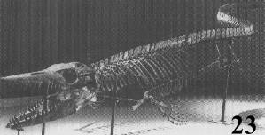 and sea animals such as the Ammonites and Mosasaurs (figure 23) threatened
Yet here was a global catastrophe. The catastrophic extinction of land animals like the dinosaurs
Darwin's whole theory. Nevertheless, many scientists fought back. One of the first
lines of defense was to ask where the crater was. The crater most people knew is
Meteor Crater, Arizona (figure 24). It is too small and it impacted at the wrong time
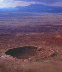 to kill the dinosaurs. Another line of defense was that, even if an asteroid did hit, it
didn't kill the dinosaurs and the other animals. Maybe something else, such as
volcanoes, caused the extinction, but over a longer period of time. When incorrectly
interpreted data did seem to support the volcanic hypothesis, a New York Times
editorial declared that the impact theory was dead.(13)
to kill the dinosaurs. Another line of defense was that, even if an asteroid did hit, it
didn't kill the dinosaurs and the other animals. Maybe something else, such as
volcanoes, caused the extinction, but over a longer period of time. When incorrectly
interpreted data did seem to support the volcanic hypothesis, a New York Times
editorial declared that the impact theory was dead.(13)
The Alvarezes continued to develop more scientific data for their theory. But
they attacked the uniformitarian assumption also. Other scientists started to look for
craters and other evidences of impacts, such as shocked quartz. They found the
crater, the shocked quartz, and plenty of other data supporting the catastrophic
death of the dinosaurs and other animals at the end of the Cretaceous. They also
discovered evidence for the catastrophic cause of other mass extinctions in other
geologic periods. Muller, whom I mentioned earlier, is one of several scientists who
are advocating multiple catastrophes, similar to what Cuvier had done nearly two
centuries ago. Yesterday's heresy is becoming today's orthodoxy.
Conclusion
This sounds like the end of the story, but it is really the beginning. Geologists
have explained so much of earth history in uniformitarian terms that a tremendous
amount of reexamination needs to be done. For example, in a paper published in
Science a few years ago, the authors report the discovery of a superflood in Siberia
larger than the one that caused the Channeled Scablands. The reason geologists had
not noticed it before was because, following the uniformitarian assumption, they had
attributed many of the observed features to glaciation. How many other earth
features are like this case? Here, flood waters actually caused the observed effects,
but uniformitarian scientists had said that glaciers did it.
Perhaps more earth scientists will start to consider catastrophic explanations as a
matter of course now that people like Bretz and the Alvarez's have broken the
ground. For example, there are boulders near San Diego, next to the Pacific Ocean
where they don't belong. Geologists call these anomalies erratic boulders. Usually,
erratic boulders are thought to have been transported by glaciers. However, these
boulders and many others like it are in Southern California where no glaciers or ice
ages occurred. So how did they arrive where they don't belong? Most likely it was
due to a catastrophic process. Perhaps an asteroid or comet impact in the ocean
created a giant tidal wave, as in the Discovery Channel program, "Impact - Could it
Happen?" (4 may 1998), or in Stephen Spielberg's "Deep Impact."
The impact-generated wave is a type of superflood. It could have inundated the
land and dislodged and moved the boulders. There are road cuts in Southern
California showing flood gravel deposited catastrophically. One is at 1500 feet in
Poway, California, about 10 miles inland from the ocean. Additionally, there is
flood gravel miles inland in the Kern River valley in California.
Let me conclude by returning to Washington State for some more geology.
Underlying the Channeled Scablands is basalt from an enormous lava flow. This is
the most spectacular geological feature in the region. It covers an area of over
100,000 square miles in parts of Washington, Oregon and Idaho. In some places it
is more than 10,000 feet thick. This solid sea of basalt was formed by successive
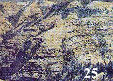 large flows of lava. The layers made by these flows are seen in figure 25.
Geologists don't know how the lava got there, except that it was not from Mount St.
Helens or the other volcanic mountains in the cascades. One flow was fast enough
and large enough to completely encase an extinct type of rhinoceros and form a
mold around it (figure 26). These immense lava flows had to have been caused by
large flows of lava. The layers made by these flows are seen in figure 25.
Geologists don't know how the lava got there, except that it was not from Mount St.
Helens or the other volcanic mountains in the cascades. One flow was fast enough
and large enough to completely encase an extinct type of rhinoceros and form a
mold around it (figure 26). These immense lava flows had to have been caused by
 one or more megacatastrophes such as an asteroid impact.
Mudflows from a Mount St. Helen's 1982 eruption in one day formed an
extensive canyon system that is up to 140 feet deep. This was near the Toutle
River. In another place, the volcano also quickly made a 100 foot deep canyon cut
through solid rock. There is a stream running through this canyon. Now if we didn't
know, we might assume that this stream made the canyon over a long period of
time. But the actual situation is just the opposite: there is a sense in which the
canyon made the stream, rather than the stream making the canyon. Basically, in a
series of eruptions, the volcano made complex geological formations in a few years,
showing that complexity does not necessarily mean long ages.
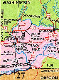
In central Washington, near the Columbia River, is Ginko Petrified Forest (figure
27). I purchased a slice of a petrified cypress tree from that forest. Stop and think
about it. How did this whole forest come to be petrified? Why didn't the trees just
decay away like they do today? Again, a megacatastrophe is the best explanation.
The same goes for any petrified forest, and there are many of them all over the
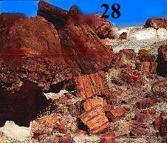 world. Figure 28 depicts petrified logs from the famous petrified forest in Arizona.
Figure 29 shows a petrified log in Mississippi. Interestingly, the logs in this
petrified "forest" did not originate in Mississippi. They are from fir, sequoia, maple,
and birch trees. They came as driftwood trees carried by water, apparently from the
world. Figure 28 depicts petrified logs from the famous petrified forest in Arizona.
Figure 29 shows a petrified log in Mississippi. Interestingly, the logs in this
petrified "forest" did not originate in Mississippi. They are from fir, sequoia, maple,
and birch trees. They came as driftwood trees carried by water, apparently from the
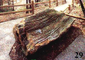 northern part of our country. They are three to seven feet in diameter, but were
stripped of their branches and bark.(14) So what mighty force uprooted forest giants
and transported them some 1000 miles? How about a catastrophic flood? (This
may be the case also for the petrified "forest" in Arizona. The giant logs there were
brought in by water.)
northern part of our country. They are three to seven feet in diameter, but were
stripped of their branches and bark.(14) So what mighty force uprooted forest giants
and transported them some 1000 miles? How about a catastrophic flood? (This
may be the case also for the petrified "forest" in Arizona. The giant logs there were
brought in by water.)
What I have pointed out is that there are plenty of unexplained data. Are there
other Cuviers, Bretzes, or Alvarezes out there who have been, or will be, willing to
question authority and assumptions? Perhaps we should consider that our planet's
past has been every bit as violent and catastrophic as the train of comets that hit
Jupiter, or our very own pock-marked moon. With such a huge number of comets
and asteroids circling our sun, are "deep impacts" more common in our history than
we would like to know? Perhaps it's good to "question authority" now and then.
Acknowledgments
I thank Dan Burton for his comments and Sharon Ann McMullen for doing the word
processing. Most of the pictures are from THE CHANNELED SCABLANDS OF
EASTERN WASHINGTON, put out by the U.S. Department of the
Interior/Geological Survey, published by the U.S. Government Printing Office,
1976. Pictures 19, 21, and 23 are from the George C. Page, American Natural
History, and Georgia Southern University Museums, respectively.
References
1. J H BRETZ, JOURNAL OF GEOLOGY, 31:637.
2. GEORGES CUVIER, RESEARCHES SUR LES OSSEMENS FOSSILES, OU LON
RETABBIT LES CARACTEES DE PLUSIEURS ANIMAUX DONT LES REVELUTIONS
DU GLOBE ONT DETRUIT LES ESPEES, 4 VOLS. (PARIS, 1811). ENGLISH
TRANSLATION FROM THE 1825 EDITION, VOL. I, PP. 8-9, BY C.C. GILLISPIE IN
GENESIS AND GEOLOGY (CAMBRIDGE, MA: HARVARD UNIVERSITY PRESS,
1951/HARPER TORCHBOOK, 1959) P. 100.
3. G.F. KUNZ, IVORY AND THE ELEPHANT (NEW YORK: DOUBLEDAY, PAGE, AND
CO., 1916) P. 236.
4. H.E. LIPPMAN, LETTER TO EDITOR, SCIENCE 137:449 (10 AUG 1962).
5. IN 1985 IT WAS ESTIMATED THAT THERE ARE STILL 550,000 TONS OF MAMMOTH
TUSKS YET TO BE UNEARTHED. A.J. SUTCLIFFE, ON THE TRACK OF ICE AGE
MAMMALS (CAMBRIDGE, MA: HARVARD UNIVERSITY PRESS, 1985) P. 108. THE
EMPHASIS IS MINE. AT 200 POUNDS PER TUSK, THIS WOULD BE 2.75 MILLION
MAMMOTHS; AT 150 POUNDS, IT WOULD BE 3.85 MILLION.
6. GEORGES CUVIER, ESSAY OF THE THEORY OF THE EARTH, WITH MINERALOGICAL NOTES BY JAMESON (NY: KIRK AND MERCEIN, 1818) P. 37.
7. LYELL'S AND DARWIN'S IDEOLOGICAL BENT IS SHOWN BY THE FOLLOWING
QUOTE: "LYELL IS MOST FIRMLY CONVINCED THAT HE HAS SHAKEN THE FAITH
IN THE DELUGE FAR MORE EFFICIENTLY BY NEVER HAVING SAID A WORD
AGAINST THE BIBLE THAN IF HE HAD ACTED OTHERWISE . . . I HAVE READ
LATELY MORLEY'S LIFE OF VOLTAIRE AND HE INSISTS STRONGLY THAT DIRECT
ATTACKS ON CHRISTIANITY (EVEN WHEN WRITTEN WITH THE POWERFUL FORCE
AND VIGOR OF VOLTAIRE) PRODUCE LITTLE PERMANENT EFFECT; REAL GOOD
SEEMS ONLY TO FOLLOW THE SLOW AND SILENT SIDE ATTACKS."
(PARENTHESIS IN ORIGINAL.) GERTRUDE HIMMELFARB, DARWIN AND THE
DARWINIAN REVOLUTION (NEW YORK: W.W. NORTON, 1959/1968) P. 387 OF 1968
REPRINT.
8. HIS FIRST BOOK WAS IN 1902.
9. NEW YORK: GARLAND PUBLISHING, INC., 1995.
10. H. MORRIS, HISTORY, P. 81.
11. R. MULLER, NEMESIS (NEW YORK: WEIDENFELD NICOLSON, 1988) P. 70.
12. C. DARWIN, ON THE ORIGIN OF SPECIES, A FACSIMILE OF THE FIRST ED.
(CAMBRIDGE, MASS: HARVARD UNIVERSITY PRESS, 1964)
P. 489.
13. MULLER, P. 84.
14. S. SCHABILION, MISSISSIPPI PETRIFIED FOREST, (FLORA, MISSISSIPPI: MPF
PUBLISHERS,1976), P.6.