 |
|
|
|
|
|
|
|
|
|
|
|
|
|
|
|
|
|
|
|
|
|
|
|
|
|
|
|
|
|
|
|
|
|
|
|
|
|
|
|
|
|
|
|
|
|
|
Email me! |
|
|
Home |
|
|
|
 |
|
|
|
|
|
|
|
|
|
|
Site Map |
|
|
|
|
Family Photos |
|
|
|
|
|
|
|
|
John Enright |
|
|
of the ENRIGHT FAMILY |
|
|
|
|
|
Enright Family Database |
|
|
|
|
|
|
Michael Enright |
|
|
|
|
|
|
|
|
|
Land |
|
|
|
This Web Site is in it's initial stages, and will be updated regularily.
If you have any information to add to the Site, please Email Me with your suggestions |
|
|
|
Michael Enright (son of Michael and Johannah), married Mary Anne Sullivan in Coraki, NSW, Australia in 1905. |
|
|
|
|
|
They settled in an area just North of the village of Coraki, known as The Glebe. Mary Anne had been born quite close to this area and her father and brother owned land nearby. |
|
|
|
|
|
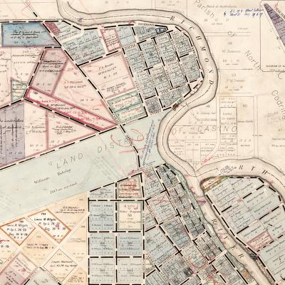
Coraki |
|
|
|
|
|
 |
|
|
|
Map showing Coraki and the The Glebe in 1923.
The Enright land can be seen at the top centre of the map, outlined in red. The village of Coraki is at the bottom of the map. |
|
|
|
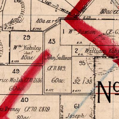
Enright Land |
|
|
|
 |
|
|
|
Map showing a closeup of the Enright Land in The Glebe
This land is recorded on Maps as being owned by the Enright Family from 1909 (the exact date is yet unknown), and is still in the family today. |
|
|
|
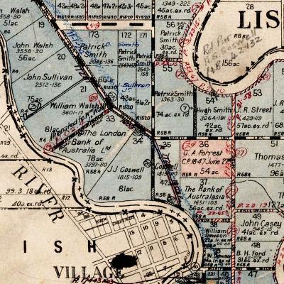
Sullivan Land |
|
|
|
Maps showing closeups of the Sullivan Land.
This land is recorded in the name of John Sullivan who was Mary Anne's brother. |
|
|
|
 |
|
|
|
This top Map shows the land in the Spring Hill area, which is possibly where the Sullivan Family were living when Mary Anne was born. Spring Hill is just to the West of where the Enright Land is in The Glebe |
|
|
|
|
|
 |
|
|
|
This bottom Map shows the land in the Codrington area. Codrington is just to the North and across the River from where the Enright Land is in The Glebe. The Glebe can be seen uncoloured in the bend of the River at the bottom of the Map |
|
|
|
|
|
This page is maintained by Michelle Hornery
Email me! |
|