|
This May, I am riding Coast 2 Coast over 3 days with my friend Ruth. We are raising money for Martin House Children's Hospice in Leeds. If you'd like to contribute, please click on 'Donate' above. Emma and Stuart ride the South Downs Way– 9-12 June, 2008 The trip started and ended with a bit of luxury, as we found we had booked ourselves into a 5-Star B&B in Winchester. A large, modern house with secluded garden a mile from the city centre, run by Heidi, a German lady with forthright manners and a very kind heart. Our ‘room’ was more like a suite – comfy living area with sofas and Sky TV, bedroom area, shower and loo. We settled in, assembled the bikes and locked them in one of Heidi’s three (yes 3) garages, then wandered into Winchester for a look around. Very lovely city, with historic buildings on every corner and between. 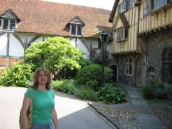
Not being that keen on cities, we bought sandwiches and wandered off to the water meadows where we sat on a bench and ate and looked for fish in the stream. In the evening we ate pizza in town, sitting out on the street in the lovely warm air, then back to Heidi’s for an early night. 
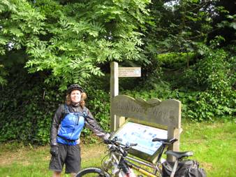
Day 1 – Winchester to Midhurst We had an excellent cooked breakfast (all organic local produce!) in the big kitchen, then quickly got ourselves ready, put all unnecessary belongings in the car, and peddled out of the drive, heading for Eastbourne. Our guide book told us that the South Down Way started outside the Cathedral. Unfortunately there were no signs to announce this fact, so we hoped for the best and posed for ‘The Start’ photos: 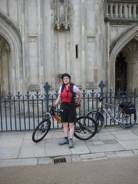 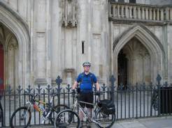
Following the signs from the high street, we found the start of the path proper. All looked very promising – surely we could just follow the arrows from here? 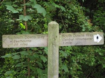
A little over-confident, we set off, ignoring a small side-shoot path to the right. After 3 miles or so of paths behind houses, we reached Tescos! No SDW signs to be seen. We backtracked a little and tried a few variations, without seeing any signs. Then I remembered the right hand fork . . . we rode all the way back and saw the sign we’d missed! Ok, the day was young and we were full of energy, this wasn’t a problem. Over the M3 we went, by special bridge, only to be faced with an impassable gate on the left, with a broken sign on it which suggested it was temporarily closed to cyclists and horse-riders, and a path on the right which led us down to a busy dual carriageway and not a signpost to be seen. (With hindsight, there may have been one cunningly concealed in the undergrowth, but we were new to this game and young in wisdom!) Well, in an emergency you get out your map and actually look at it. Finding the alternative route on that, we headed off, if not happily at least glad to be on track, up the side of the busy road to where a small lane led off. Another couple of miles led back to the dual carriageway, so we backtracked again and finally headed down a dead end labelled ‘To the Church’. Beyond the church the road became a track, and we were back on the SDW proper. 10 miles ridden, we were perhaps 3 miles from Winchester! Hurrah. Proper mountain biking at last, whizzing through the single track with nettles and brambles ripping at our legs, the sun shining and the views opening out promisingly. We passed a heavily laden walker, so I slowed down to ask if he was going far. ‘99 miles!’ he replied. ‘Oh, so are we.’ We wished each other luck, and cyclists left walker far behind. Cyclists kept on happily, following the obvious track (note: big mistake), which curved downhill between trees and fields. A hare leaped out and ran in front of us, which was a thrill. Then we reached another dual carriageway. Or maybe it was the same one further on. We crossed it and pored over the map and guide book, trying to fit the descriptions to our location, but it couldn’t be done. Back we went again, up the track, no sign of obliging hare. Our mistake was clear: the obvious track was the wrong one. We should have headed straight on on a grassy path, which was actually signposted, but we weren’t yet attuned to the many subtly different signs in use. Back on track again! Shortly thereafter we came up behind our friendly long-distance walker . . . Perhaps he won’t realise we’re the same people? No such luck; he glanced at Stuart and began to laugh! I explained we’d been lost. ‘All part of the adventure,’ he told us wisely. Which is all well and good but our planned ride of 35 miles was getting longer by the minute. We agreed to be much more careful at all junctions, and made good progress. At a crossroads we stopped for some lunch, with a rather pretty cottage as a backdrop. The next landmark after lunch was the Queen Elizabeth Country Park, which we approached via a lovely grassy downhill, reaching maximum speeds for the day. This provided the delights of proper loos, a café and visitor centre, but we only had time for the former as we were beginning to worry about all the lost time and we still had a long way to go. Never mind. Now we understood about looking out for signs, we’d be fine. We whizzed through the Park, on a lovely swoopy bridleway that spat us out on a road. Not a dual carriageway this time. But again, that worrying lack of signposts. Consulting the Sat Nav told us we were not where we wanted to be. Consulting the map (which only shows the SDW itself and a little on either side) showed us we weren’t on it. I mean not on the map, never mind the SDW. Oh joy. We rode along the lane in each direction hoping for inspiration, before realising that the only option was to backtrack yet again. Back along the lovely swoopy bridleway . . . which turned out to be mostly uphill when ridden in reverse. Eventually we found a turning we had missed, marked by a tiny little arrow cunningly positioned so you couldn’t really see it unless you’d already made the turn. A long and hard climb up through the woods began to take its toll and my spirits were falling fast... Luckily the next section was through National Trust country – Harting Down and Beacon Hill, our first stretch of real Downland scenery, and lovely enough to restore spirits. Even Stuart relaxed enough to shed rucksack and helmet and lie in the buttercups and just enjoy the sun! 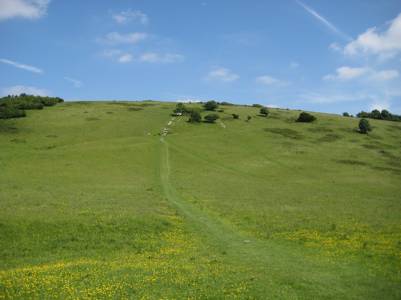
That’s called Beacon Hill and is quite a scramble even for walkers. Luckily cyclists get to go round: 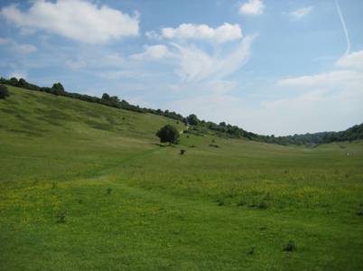
Soon after this, we were travelling through woods when we spotted this memorial to a German pilot who must have crashed here in the war – we mean to find out more about him and his plane if we can: 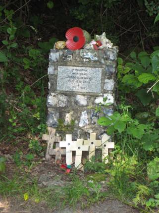
We didn’t go wrong again, but as the ride went on and on we began to panic. We were due to leave the SDW at Cocking (yes really), from where we would ride 3 miles up the road to our B&B at Midhurst. I had assumed that Cocking would be obvious so was blithely going on until I saw it. Now Stuart got the map out and pointed out that we probably couldn’t actually see it from the path, so we might have missed it. The thought that we might now be riding track that belonged to Wednesday, and would have to backtrack yet again got us panicking. Sat Nav confirmed we were only a mile from Cocking, so we decided to go on a bit further. After all, we were supposed to see a ‘large chalk ball’ at the side of the track just before we got there and we hadn’t seen it yet. Or at least we hadn’t noticed it. Stuart set off ahead, and as he rounded the next corner I heard a jubilant cry: ‘Yes! There it is!’ It was indeed a large chalk ball: 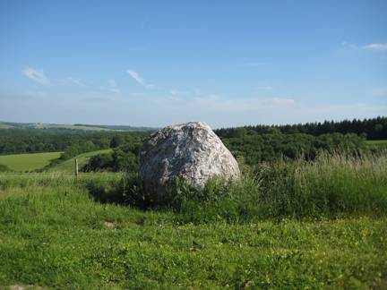
I had high hopes for an ice cold lager in Cocking (not exactly Alexandria, but beggars can’t be choosers). And when we got there, there was the pub. Shut. At 5.30pm. What is the country coming to? So it was off up the main road, scarily busy after our day in the wilderness, to Midhurst where we quickly found our B&B – Pear Tree Cottage. We were to stay in their little self-catering annexe, nicely done out with a little kitchen, bathroom and bed-sitting room, with sofa and TV (no Sky this time, but it was cheaper!). Instead of the planned 38 miles, we had managed to ride just over 50! I peeled off sweaty gear and dived into the shower, and Stuart headed round the corner to Tesco Express for beer. I shall write elsewhere of the indignities of that cycling related injury known as ‘chafing’. It would be Too Much Information for public consumption. But I was sore! After the day’s misadventures, some map checking (over beer) was called for: 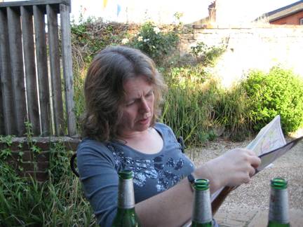
We had a wander round the town of Midhurst, pretty but less twee and a bit more vibrant than some of the local centres of habitation. Found a lovely pub which served excellent food, and did what I could with their Fisherman’s Pie. Unfortunately all that exercise had left me unable to eat, and I was feeling far too full for pudding, when I could have had one without any guilt! By 8.30 I was falling asleep, so we crawled into bed and passed out! 12 hours later, having eaten the ‘continental’ breakfast left in our kitchen (i.e. nothing cooked!), we were off again for the 2nd stretch. Fortunately this was only going to be about 30 miles, and we were looking forward to an ‘easy’ day. Which broadly speaking it was, though Stuart felt under-par due to his usual reaction to any water not from Yorkshire! Most of the tracks were classic South Downs – along a high chalk escarpment, with a steep drop to the left and a gentle tumble of fields and trees to the right, with eventually views of the sea (and apparently the Isle of Wight, but we could never spot it). A pattern emerged: you swoop down from the heights to cross a road, river or railway (often all three). Occasionally, there is a nearby village or tearoom but these are few and far between so you have to plan your food stops. Today we were super-efficient, and left the path just before crossing the river Arun to ride a mile to Houghton Bridge tearooms. OK, time for an aside on ‘Southern Weirdness’. What is a sandwich? In the north of England, it is served in a soft bread roll, usually known as a breadcake where I live, but I think there is much regional variation. Bit like a good-sized burger bun without the sesame seeds. It can be grasped firmly, and the filling usually stays put. In the south, a sandwich is served in bread. Even a bacon sandwich. It looks delicate, charming, unsustaining, and it falls apart as soon as you pick it up. The price was pretty southern too (Stuart uttering the Yorkshireman’s battlecry: (‘Ow much??’) Anyway, food was welcome and the gooseberry and ginger cheesecake was excellent. And over the River Arun we went: 
Photo from http://www.bikedowns.co.uk/ - thanks to Anthony whose site it is. More climbing took us to, for me, the highlight of the whole trip: Chanctonbury Ring, and the descent from there. Chanctonbury Ring is an Iron Age hill fort, planted with beech trees in 1760, which grew to an impressive height on this already lofty spot which commands amazing views in all directions. Unfortunately most were flattened by the hurricane of 1987, but the replacements are coming on well. 
It’s an attractive spot, the views are awesome, and the descent from it is long, grassy, smooth and great fun. Off I shot: 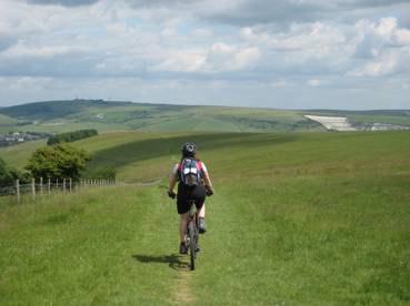
Our destination for the night was Bramber, only a mile from the SDW, along the Downs Link Bridleway. Unfortunately we didn’t realise that and rode along a busy highway flanked with signs about how many casualties there had been on that stretch this year. We stayed at the Old Castle Inn, Bramber: 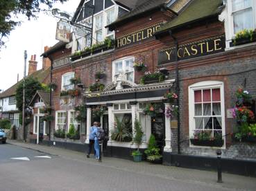
The room was small and stuffy, but adequate. During the day the slightly tender sensation on my right buttock had moved from 'slightly bruised' to 'very tender', so Stuart kindly examined it. The First Aid kit got some more use: he sprayed me with Elastoplast plastic skin. The 'slight stinging sensation' turned out to be the worst pain I’d experienced in a long while and I had to stuff a pillow in my mouth to stifle my screams. A dressing went on top of that and luckily it didn’t bother me too much after that. Bramber boasts the remains of a Norman castle: 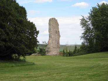
This was to be 40 miles, and we’d been warned that the steepest climbs would be in this section. To make matters worse, the beautiful warm weather had broken with torrential rain during the night. It stopped just before we set off, but chalk gets slippery when wet and this added to my anxiety. We found the bridleway this time, and this delivered us safely to the South Downs Way. Unfortunately we now had to cross the busy and dangerous road we�d ridden the afternoon before. After waiting 5 mins without a gap in the traffic, we chose to join it, ride to the nearby roundabout and back as the only way of getting across! There followed the inevitable climb, some track and some (blessed) tarmac back up to the heights. This first climb of the day took us past Truleigh Hill Youth Hostel �originally planned as our destination for the previous night, but it was fully booked. It has the distinction of being the only accommodation right on the South Downs Way. After descending through trees to a road, we looked back and saw from the signpost that we�d just passed the famous Devil�s Dyke. Unfortunately the path doesn�t quite go there and the whole feature is hidden by trees! Looking back, this is what we saw: 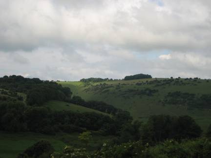
We had come down the little track on the left of the trees and missed it all. Up we went again, wiggling through farmyards and up Newtimber Hill. Down again, more wiggling through farmyards, then up again, this time through a golf course. Signs recommended we ‘beware of flying golf balls’. How on earth are you supposed to do that? Surely the first you know of it is when it hits you on the head? Better surely if the golfers beware of the occasional cyclist? As an aside, we saw very few other mountain bikers on the trail, and most of those looked as if they were out for a local ride. This may have been because we rode mid-week, but overall it was surprising how quiet the SDW is, away from the vicinity of car parks. And even the walkers we met were friendly! Stuart rang his bell as we came up behind a couple walking their dogs. As usual (!) they didn�t respond at all. We eventually called ‘hello’ and passed them, and the woman said ‘Oh, I wondered what that noise was, I thought it must be some sort of bird!’ Next landmark we reached, after passing the Jack and Jill Windmills was Ditchling Beacon. This has a reputation on the London-Brighton ride as a bit of a climb, so it was pleasantly anti-climactic to find we just glided into the car park, having done all the climbing earlier. Less pleasant to find no sign of the ice cream van which our guide book promised us would be there. The morning’s best bit of weirdness was passing through the Loudest Flock of Sheep in Britain. These guys bleated at us, every one of them, in deafening and scary tones. I don’t think they wished us well. This turned out to be the Day of Sheep, and our bikes and legs became plastered with what sheep leave behind them. We then descended through a field of cows, which took some dodging. When Stuart yelled ‘Move, you dozy cow!’ I don�t think he was talking to me�. The weather, so good for the first 2 days, descended into short, sharp showers, accompanied by icy winds. My new rain jacket got an airing. 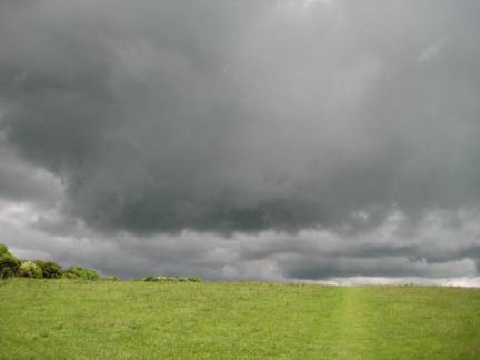
Pain started to set in now, mixed with exhaustion and hunger, as we hadn’t planned our lunch stop properly. Alfriston beckoned as the only beacon of hope (and food) and it seemed a long time coming. By the time we pedalled into the very pretty village, we were damp, smelly, and our bikes and legs were covered in sheep shit. We were not tea-room material. So we sat in the village square, shivered, and ate all the food I could lay my hands on from the deli. After Alfriston, there are only about 9 miles to go, but they are tough miles, and my body was saying ’Surely that’s enough, now?’ My upper thighs were chafed and sore, and I began to think very dark thoughts about whoever designed this ridiculous route. The last 9 miles, couldn’t they all be downhill? A gentle roll down to the sea? No. You have to climb and descend two more hills. I felt a lot grumpier even than I looked: 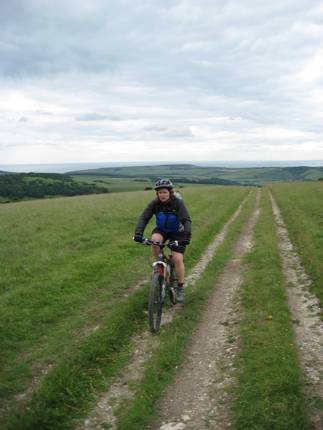
We had been told to divert and admire the Long Man of Wilmington, but we were past caring, so this is what we missed: 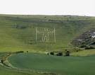
One of the last stages involved cycling over a golf course, where I saw a man walking four or five beautiful border collies � my favourite dog. I was so busy admiring them, I got my wheel in a rut and flew off the bike, landing on my chin. After that I took the last couple of miles very carefully. The track meanders through some common ground above Eastbourne, where we spotted a fox cub, and then we reached � the end. 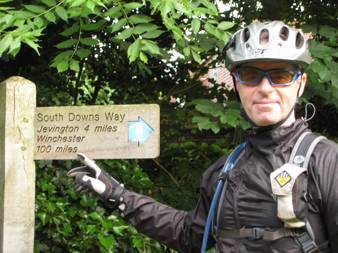
With a sense of relief and anti-climax, we rolled on down into Eastbourne, found the station and within half an hour were on a train bound for Clapham Junction, where we humped the bikes down and up stairs to find our Winchester train. Smelly, sweaty and covered in sheep shit, we probably weren’t anyone’s ideal travelling companions. We arrived at our B&B exhausted, starving and sore. I was only able to waddle about with my legs apart, which was probably very comical for everyone else. The sainted Heidi knocked on our door with a tray of sandwiches, melon, tea and wine, which act alone should assure her place in heaven, should there turn out to be one. If you've read this far, thanks! This is my first ever web page, so I apologise for any rubbish design, and also any inaccuracies in the above, as one week on it is all starting to blur! |