| Welcome the the Landsat Data Continuity
Mission (LDCM) website! This site is intended to be a resource for the
global remote sensing community for information related to the LDCM mission.
Additional information is available at the NASA
LDCM Website.
The Landsat program has a long history of providing satellite remote
sensing information to the world, over 28 years. The first seven Landsat
spacecraft have collected the longest continuous space-based remote sensing
dataset in the world. The National Aeronautics and Space Administration
(NASA) and the U.S. Geological Survey (USGS) are working together on the
next mission in the Landsat series, called the LDCM.
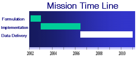
NASA and the USGS are proceeding with a two-step procurement to accomplish
the delivery of Landsat continuity data to the U.S. Government. The timeline
shown below represents a top level summary of the mission timeline. The
mission is realized through a sequence of phases, Formulation and Implementation,
with the goal of acquiring the first data in 2006. The Request
For Proposals (RFP) for the Formulation phase was released November
1, 2001.
|


 U.S.
Department of the Interior
U.S.
Department of the Interior