Canan Topkaya
010030806
Jeodezi ve Fotogrametri Mühendisliği
REMOTE SENSİNG
Remote sensing is the technology of observing the Earth from space. A weather image on the evening news is a familiar example. The Earth's surface and atmosphere naturally radiate energy in the form of microwaves.Remote sensing is the science and art of obtaining information about a phenomenoa without being in contact with it.Remote sensing deals with the detection and measurement of phenomena with devices sensitive to electromagnetic energy such as: Light (cameras and scanners),Heat (thermal scanners) ,Radio Waves (radar) ..These remote sensing resources focus on practical aspects of accessing, visualizing, and processing remotely sensed data. Sufficient links are provided for those interested in pursuing details of the science and technology of remote sensing. Information available on this site, however, is written for those who are interested in learning about working with satellite imagery. Although documents focus on issues of biodiversity conservation, they are applicable to a broad range of applications.Remote sensing is the ability to measure the properties of an object without touching it. Almost all of the applications of remote sensing to date have been based on observing crops in distinct areas of the electromagnetic spectrum. The spectrum is represented in the figure below. Agricultural remote sensing is commonly done in the visible, near-infrared and thermal infrared portions of the spectrum; however, new applications in the microwave area are under development.
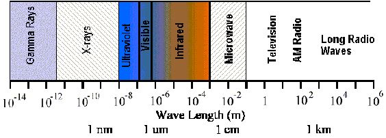
It provides a unique perspective from which to observe large regions.Sensors can measure energy at wavelengths which are beyond the range of human vision (ultra-violet, infrared, microwave).Global monitoring is possible from nearly any site on earth.
Remote sensing is the technology of observing the Earth from space. A weather image on the evening news is a familiar example. The Earth's surface and atmosphere naturally radiate energy in the form of microwaves.
The microwave spectrum is rich with information about the atmosphere (temperature, humidity, clouds, and rain) and the Earth's surface (temperature, vegetation, roughness, and moisture). Since microwaves can penetrate clouds, surface characteristics can be measured from space even when clouds are present. Applications of this technology include deducing wind speed and direction over the world's oceans from surface roughness measurements, measuring rainfall, and monitoring variations in polar sea ice extent. As the population of our planet increases, it becomes vital that we better understand the physical processes that govern our climate and weather. In this pursuit, Remote Sensing Systems provides research-quality geophysical products from satellite data for studying climate variability and weather systems. These data products are revealing many secrets of our wondrous planet, Earth.
Remote sensing of Environment serves the remote sensing community with the publication of results on theory, science, applications and technology of remote sensing of Earth resources and environment. Thoroughly interdisciplinary, this journal publishes on terrestrial, oceanic, and atmospheric sensing. The emphasis of the journal is on biophysical and quantitative approaches to remote sensing at local to global scales. Areas of interest include, but are not necessarily restricted to:agriculture, forestry and range ,biophysical-spectral models ,ecology ,earth and environmental science,geography and land information ,geology and geoscience,hydrology and water resources,image processing and analysis,atmospheric science and meteorology,oceanography,sensor systems and spectral-radiometric measurements.
http://foto.hut.fi
Measurements
The amount of energy radiating from a surface in a particular portion of the spectrum is measured by an instrument called a radiometer. Radiometers can be hand held for research purposes and monitoring small field plots or placed on board aircraft and satellites to survey entire fields, farms, or agricultural regions. The amount of radiation from an object (called radiance) is influenced by both the properties of the object and the radiation hitting the object (irradiance). When the sun is used as the source of irradiance, the irradiance is not constant (varying with the time of day and atmospheric conditions); therefore, the radiance of an object is not necessarily a good indicator of physical properties. Instead, the apparent reflectance of an object is best used to learn about its properties. Reflectance is the ratio of the radiance from an object to the irradiance reaching the object. The reflectance of an object can be impacted by the angle you are looking from and the angle of the sun (for more information on this, see the section on bi-directional reflectance). The radiometer has special filters that can be designed so that only radiation from a specific part of the spectrum is measured.
Some Interesting Links
Referances :
·
www.remss.com/about_rss.html
·
www.elsevier.com/wpsproduct/cws_home.html
·
www.ciesin.columbia.edu/TG/RS-home.html
(Not: Hocam ilk ödevi, yanlışlıkla silindigi için yeniden hazırladım.)