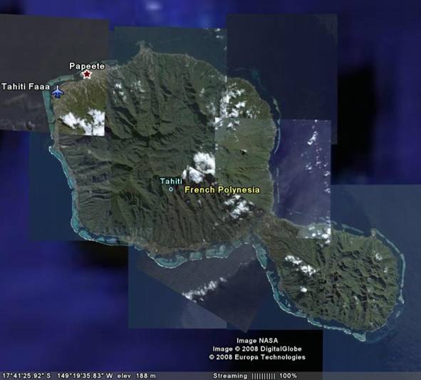
The water around the volcano is hotter than would be expected at depths, due to the interaction with the hot erupted material. This hot water, and the volcanic island itself, is useful when helping to establish the carbonate reefs which begin to fring many volcanic islands. The reef can be seen in the image of Tahiti above, as a thin white band offshore of the island, with lagoons represented in the light blue water behind it.
The first theory as to why the reef forms around the island was proposed by Charles Darwin, during his voyage on the HMS Beagle which also produced his landmark The Origin of the Species. As outlined by Duff (1988), the fringing reef collects when the microscopic larvae of corals, along with spores of coralline algae, are attached to the volcanic island and attach to it. If they have suitable growing conditions, such as warm water and light, they can begin to grow. Darwin observed that reefs can grow upwards at around 5mm/year, and Duff estimates that the island subsides, due to lithospheric cooling, at 0.2mm/yr. Eventually, the centre of the island (the volcano) subsides, leaving behind the reef, which becomes an atoll.
Darwin's theory explains subsidence, but does not fully describe depositional history. From investigations on the Johnston Atoll near Hawaii, drilling has revealed shallow carbonate slopes from the surface to around 122m water depth. Below this, the slope becomes near vertical, including topography that can be described as cliffs. (Keating, 1987)
Camoin et al's analysis of Pacific Islands shows that the islands undergo periodic drowning, as well as erosion from surface processes. This is evidenced by karstification features such as sinkholes and caverns. This allows for the buildup of cliffs at depth, as the carbonate reef grows to maintain its position in the light and nutrient rich photic zone (the top 20m of water). The periodic drowning is likely to be caused by glaciations, as outlined by Daly, and described by Duff (1988).
It is worth noting that in the case of the volcanic island-atoll systems of the Pacific, the reef develops on all sides of the islands. On isolated carbonate platforms, the reef only develops on the windward side of the platform, a useful diagnostic feature for analysis of drowned platforms.
As the volcano subsides, due to erosive and tectonic processes, a shallow lagoon forms in the middle of the circular reef. At this stage of its development the island system is known as an atoll. The interior lagoon is characterised by evaporite deposits, and in some cases phosphate deposits such as those on Christmas Island (Manten, 1972). The island of Tupai, in French Polynesia, lies northwest of Tahiti and the evolution of the island system can clearly be seen. There is no volcanic core, and the lagoon has become established in the middle of the island. The image has been taken from Google Earth:

51% Coralline Algae
20% Coral
2% Shell Fragments
1% Halimedia
16% 'Fine Debris'
However, changes in sea level change the areas of deposition across the island, altering its morphology. The cartoon below shows how this can occur (after Longman, 1981)

At depth, the increased pressure makes the aragonite polymorph a stable form (Keating, 1987) of calcium carbonate (CaCO3), which is not normally observed at the surface.
References:
Camoin, GF et al (1988) "Development and demise of mid-oceanic carbonate platforms" in "Reefs & Carbonate Platforms in the Pacific and Indian Oceans" Davies, PJ & Camoin, GF (eds), Special Publication No. 21, International Association of Sedimentologists, Blackwell, London, UK, p57-64
Duff, Donald (ed) (1988) "Coral Reefs and Atolls" in Donald, Duff (ed) "Holmes Principles of Physical Geology (4th edition)", Stanley Thornes, Cheltenham, UK. p571-579
Keating, Barbara(1987) "Structural Failure & Drowning of Johnston Atoll, Central Pacific Basin" in "Seamounts, Islands, Atolls" Keating, Barbara (ed), American Geophysical Union, Washington DC, USA, 1987, p49-58.
Longman, MW (1981) "A process to recognizing reef facies complexes" in "European Fossil Reef Models" Toomey, DF(ed) Special Publication of the Society of Economic Palaeontology and Mineralogy, Tulsa, USA. Volume 30, pp9-40
Manten, A.A. (1972) "C. Wyville Thomson, J. Murray and the 'Challenger' expedition" in Earth Science Reviews, Elsevier Science, Amsterdam, The Netherlands. Volume 8(2) p255-266
Roehl, U & Ogg, J.G. (1988) "Aptian-Albian Eustatic sea-levels" in "Reefs & Carbonate Platforms in the Pacific and Indian Oceans" Davies, PJ & Camoin, GF (eds), Special Publication No. 21, International Association of Sedimentologists, Blackwell, London, UK, p98-124