Index
Guestbook
Current data using GRS 80 (NAD 1983) was developed following my email correspondence with Dr. Dennis G. Milbert Chief Geodesist NOAA, National Geodetic Survey, N/NGS 1315 East-West Hwy., SSMC3, Room 8635 Silver Spring, MD 20910-3282 which began Wed, 06 Mar 2002 07:24:21 -0500. Adjustments of POB were completed by 12/18/2005 - see line 588.
Links
COMPARISON OF DATUM ELEMENTS
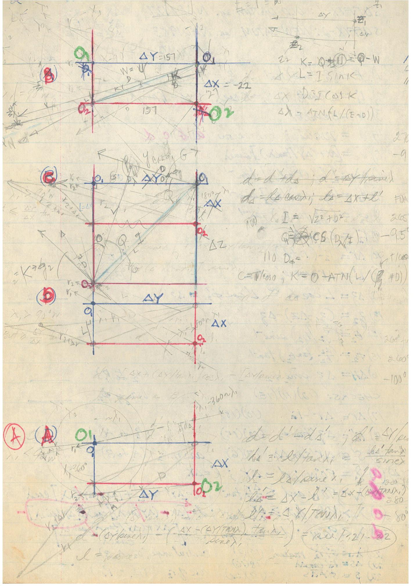
Note: Lines 5 ~ 70 measure on KYMAK datum, a sphere; equations following line 70 transform to the reference ellipsoid indicated.
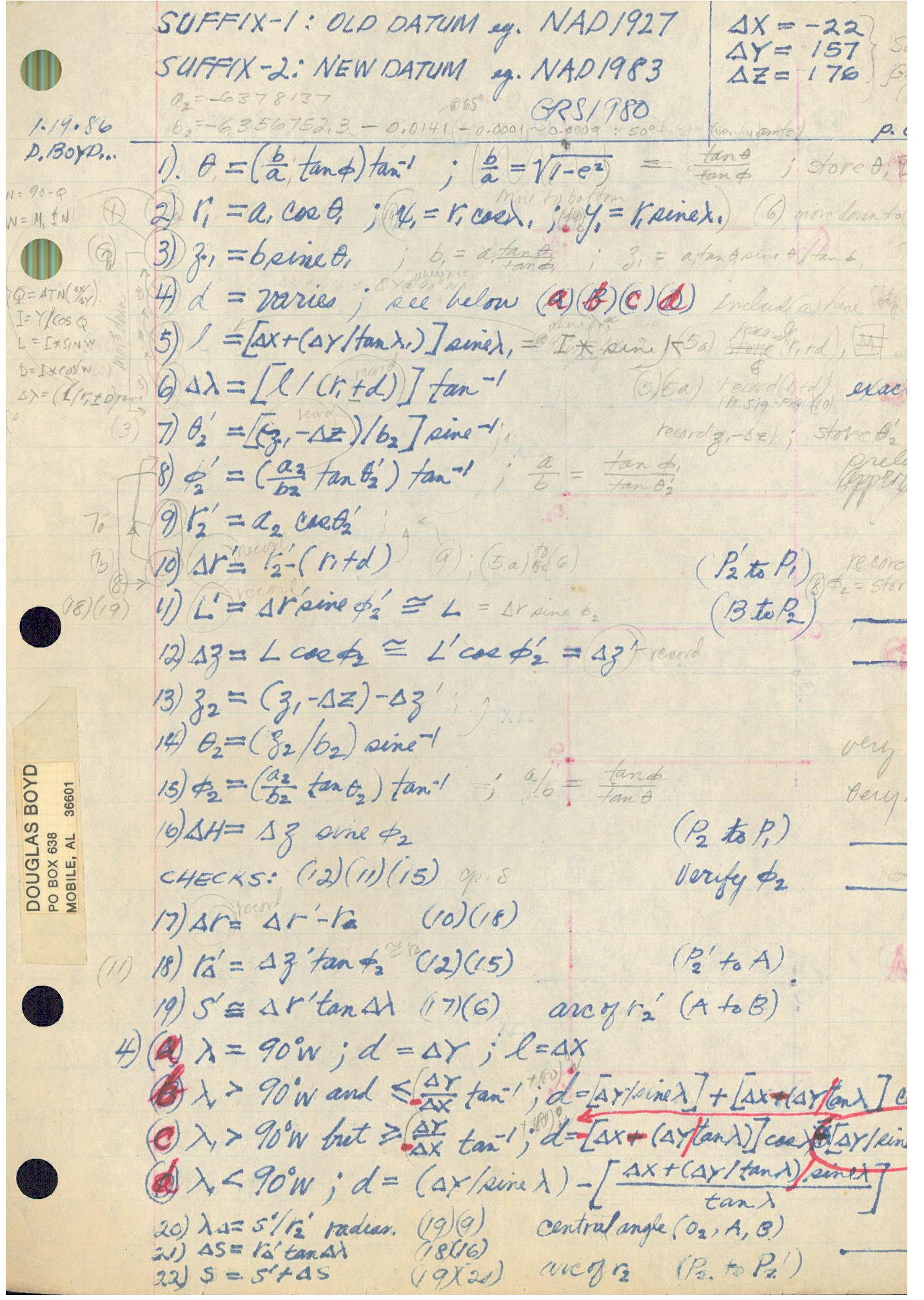
FORMULAS
(parametric datum transformation - how formulas were derived.)
TANDY PC-4 (c. 1985) "BASIC" language.
Please note: In line 20, L has changed from a geodesic to a parallel, as is K. An asterisk, * will be used to mark these corrected coordinates where shown on KYMAK webpages. c. 2012
Program # 1
__________________________________________
5 PRINT“KYMAK”:J=1609.344:R=3950*J
10 INPUT “Distance”,S:S=S*J:INPUT ”Offset”,T:T=T*J
20 MODE 5:I=S/R/2:E=R*Cos I:L=S/E/2:L=2*E*Sin L
25 G=T/E/2:K=2*E*Sin G
30 MODE 4:D=Sqr(K*K+L*L:C=2*Asn(D/2/R:Q=Atn(K/L
55 F=11.75:
PRINT”Azmuth +/- F & Q:INPUT“Bearing”,F
60 GOTO 583
65 G=Acs(CosV*CosC+SinV*SinC*CosF
70 W=Asn(SinC*SinF/SinG:O=90-G:
75 U=M-90:Q=Atn(X/Y:I=Y/CosQ:E=R*CosO
80 INPUT”K”,K:IF K=0 THEN 250
81 IF K=1 THEN 251:REM K=1 if "S" distance is east of POB
82 IF K=2 THEN 252:REM K=2 if "S" distance is > 90+Q (Q=ATN(X/Y)
83 IF K=3 THEN 253:REM K=3 if "S" distance is between longitude 106.3527415 deg. and POB
84 IF K=4 THEN 254:REM K=4 at POB where all measurements = 0
85 L=I*SinK:D=I*CosK:S=Atn(L/(E+D)
90 INPUT"Datum 2",N:IF N=0 THEN 300
91 IF N=1 THEN 301:REM N=1 is for points east of POB
92 IF N=2 THEN 302:REM N=2 is for points west of longitude 106.3527415 deg.
93 IF N=3 THEN 303:REM N=3 is for points between POB and longitude 106.3527415 deg.
94 IF N=4 THEN 304:REM N=4 is at POB
100 M=(D+E)/CosS
110 G=(R*SinO-Z)/M
120 P=((A/B)^2*G
130 U=Atn(B/A*P:P=AtnP:T=A*CosU
140 H=(M-T)/CosP:INPUT"7",I:
IF I=7 THEN 766
150 PRINT P,N,H:END:
REM “P”=latitude;”N”=longitude;”H”=h (ellipsoidal height)
250 PRINT Ke=1;Kw=2;Kb=3;Kc=4:GOTO 80
251 K=Q+W-U:GOTO 85
252 K=U+W-Q:GOTO 85
253 K=Q-W-U:GOTO 85:REM W + U, 90 + Q at line 75 and > M at line 75 and line 588
254 K=Q-U:GOTO 85
300 PRINT Me=1;Mw=2;Mb=3;Mc=4:GOTO 90
301 N=M-W+S:GOTO 100
302 N=M+W-S:GOTO 100
303 N=M+W+S:GOTO 100
304 N=M+S:GOTO 100
484 B=B+0.014:X=X-0.9956:Y=Y-1.9013:Z=Z-0.5215:GOTO 65:
REM WGS84 for GPS (b=a-fa)
POB N 39.0908733888 x 94.4279813064
h=2574.363M (corrected 12/18/05)
583 A=6378137:B=6356752.3
588 M=94.36979847:V=90-39.071644754:
REM Previously, M=94.37020442:V=90-39.071586376 corrected 12/18/05, estimated by measuring on map, moved 21.31ft north x 114.66ft east. Further adjustment may be needed - first order station point is required but unavailable at this time due to expense.
593 X=6830.025:Y=23277.302:Z=4931.751:X=X+6.72187753:Y=Y-155.4631616:Z=Z-177.0137639:
REM POB (corrected 12/18/2005 see line 588)
N 39.09085867 x 94.42799108 W
h=2575.57 M (verify);
Rn=101.175; Rm=78.845 fps (using program #0, see below)
POB previously estimated,
N 39.09080015 x 94.4283950383 W
h=2575.596 (verify);
Rn=101.1749; Rm=78.845 fps
(corrected 12/18/2005 see line 588)
Data sheets - http://www.ngs.noaa.gov/cgi-bin/ds_mm.prl
596 INPUT "84",I=84:IF I=84 THEN 484
599 GOTO 65
766 G=AtnG:L=T/CosG:
H=(M/CosG-L)*Cos(P-G
770 I=L+H/Cos(P-G
775 D=P-Asn(((T*TanP-B*SinU)*CosP)/I:
D=D-G
777 G=Tan(G-D:GOTO 120
Notes:
__________________________________________
12 INPUT "T=T+L*T",T:REM This step is not normally used.
14 N=5:GOTO 20
15 N=45-Q:O=SinN*D:P=O/CosQ:N=P/(M*J+S):L=N*T:T=T+L:
33 INPUT "N=",N:IF N=5 THEN 15
50 S=S=M*J:L=P/S:GOTO 10:REM This step goes with line 12.
REM Use "N" to adjust cummulative error in "T"
500 REM X=X+8:Y=Y-160:Z=Z-176:M=94.370186570:V=90-39.0715683177:
REM NGS alternate for line 588 ~ 593 (not to be used) h=2571.5206
527 REM (OBSOLETE NAD27data)
A=6378206.4:B=6356583.8
M=94.37019035:V=90-39.07160165:
GOTO 65:
REM NAD 1927 (Obsolete)
POB N 39.09079649 x 94.42816494 W
h=2608.874098
550 REM Obsolete NAD27 cp. line 593
X=6823.30353:
Y=23432.76535:
Z=5108.76508
__________________________________________
Using Google for mathematical calculations
http://www.google.com/help/features.html#calculator
Formulas:
line 20 MODE 5(radians)
I=S/R/2=750/3950/2 search on Google finds:
(750/3950)/2 = 0.0949367089 = I
L=2*R*SinI
sine(750/3950/2)radians on Google finds:
sine((750/3950)/2)*radians = 0.0947941627 = sineI
2*3950*sin(750/3950/2)radians finds:
2*3950*(sin((750/3950)/2)*radians) = 748.873885 = L
E=R*CosI
3950*cos(750/3950/2)radians finds:
3950*cos((750/3950)/2)*radians = 3932.21273 = E
G=T/E/2
750/(3950*cos(750/3950/2)radians)/2 finds:
(750/(3950*cos((750/3950)/2)*radians))/2 = 0.0953661527 = G
K=2*E*SinG
2*(3950*cos(750/3950/2)radians*sin(750/(3950*cos(750/3950/2)radians)/2 finds: 2*(3950*cos((750/3950)/2)*radians*sin((750/(3950*cos((750/3950)/2)*radians))/2)) = 748.863679 = K
Line 30 MODE 4(degrees)
D=Sqr(K*K+L*L
(2*(3950*cos(750/3950/2)radians*sin(750/(3950*cos(750/3950/2)radians)/2)^2 finds:
2*(3950*(cos((750/3950)/2)*radians)*(sin((750/(3950*cos((750/3950)/2)*radians))/2)^2)) = 71.3080456????????????????
???????????????????????? 748.863679^2 = 560796.81 = K^2
Your search - (2*(3950*cos(750/3950/2)radians*sin(750/(3950*cos(750/3950/2)radians)/2)^2 - did not match any documents.
??????????????????
(2*3950*sin(750/3950/2)radians)^2 finds:
(2*3950*(sin((750/3950)/2)*radians))^2=560812.096 = L^2
sqrt((2*(3950*cos(750/3950/2)radians*sin(750/(3950*cos(750/3950/2)radians)/2)^2+(sine(750/3950/2)radians)^2 finds:
(To be continued)
C=2*Asn(D/2/R
Q=Atn(T/S
__________________________________________
Program # 0
__________________________________________
Arc lengths in feet per second:
x= latitude (Rm); y= longitude (Rn)
10 x=2*3.1415926535897932384626433832795
*(B^2/(A*(CosP/CosU)^3)/J/21600*5280/60
20 y=2*3.1415926535897932384626433832795
*(A*CosU)/J/21600*5280/60
Continued
