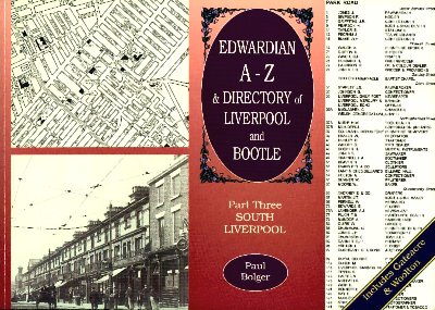
Part Three SOUTH LIVERPOOL includes Gateacre & Woolton
By Paul Bolger
Published by Stations U.K.
�9.99 ISBN 0 947562 07 9
80 pages
Copyright 2002 Paul Bolger
The Trade Directories used are the 1908 and 1909 Kelly's Directories. Only the main routes are covered and the Heads of Households of private dwellings are not included.
The routes covered by the trade directories:
Admiral Street
Aigburth Road
Allerton Road, Woolton
Belle Vale Road
Church Road, Garston
Gateacre Brow
Granby Street
Halewood Road, Gateacre
High Street, Wavertree
Lark Lane
Lodge Lane
Mill Street
Park Place
Park Road
Parliament Street
Rose Lane
St. James Place
St. Mary's Road
Sefton Street
Smithdown Road
Speke Road
Upper Parliament Street
Upper Warwick Street
Warwick Street
Window Lane
Windsor Street
Woolton Road, Garston
Woolton Street
Page index of the photographs/illustrations used in this book:
Front Cover: Park Place
2. 162 High Park Street 1920s showing Lucy Martha Heron's Greengrocer's shop
4. Illustration showing Key to Maps
6. Beresford Road 1906 showing The People's Protestant Hall
7. Webster Road 1949 showing the Cameo Cinema
Prince's Avenue c.1905 showing Babtist building
8. St. James Place c.1935 showing St. James Station platform
9. Park Place showing row of shops. This photograph is also used for the cover.
11. Aerial Photograph 1930s showing Prince's Road
13. Smithdown Road 1951showing The Salisbury Laundry and Robert Evans (monumental sculptors)
Lodge Lane 1933 showing The Croxteth Hotel Pub and Glendinnings (fishmongers and poulterers)
15. Wavertree Windmill 1898 (two photographs)
High Street, Wavertree c.1918 showing row of shops numbered 98-102a
19. Childwall Lane 1957 showing signpost at Well Lane
Childwall Lane 1907 showing Childwall Abbey
Gateacre Brow mid-1930s showing Post Office and Pharmacy
20. 82-84 Aigburth Road showing Langhorne's House Furnisher
22. Inside Midland engine shed, Brunswick 1927 showing a train engine
23. Aerial Photograph early-1930s showing area from Sefton Street to Mill Street
25. 439 Mill Street, Dingle c.1908 showing Procter's Variety Bazaar
View from the Ironbridge, Dingle 1956 showing railways at Herculaneum Dock
27. Aerial Photograph 1930 showing Sefton Park and Fulwood Park area
59 Lark Lane early-1920s showing The "K" Garage
29. 40 Penny Lane 1912 showing Bridge House Newsagents
32. The Cast-Iron Shore 1925
33. The Dingle Picturedrome, Park Road c.1912
Dingle Lane 1910 showing a tram
35. St. Michaels 1909? (the location featured in this photograph is uncertain)
Otterspool Station c.1910
37. Rose Lane c.1919 showing B.R.Ayers Garage
Aigburth near Sefton Park c.1902 showing trams
41. High Street, Woolton 1937 showing trams
Woolton Street c.1907 showing shops at No.10 and No.8
42. Shore Cottage near Fulwood Park c.1925
48. Aigburth Road, Cressington c.1916
51. Kettle Nook, Garston 1901
"Paddy Flynn's Cottage" Church Road 1920s
52. Speke Junction 1924 showing train
53. Speke Junction 1954 showing train
54. New Dock, Garston 1897
55. Aerial Photgraph 1930s showing Garston Docks
56. Two photographs showing Sentinel steam-wagons
58. 249 Park Road 1933 showing Charles Amy clothing store. Also shown is Wm Boadle's Tea store
63 South Street c.1908 showing E.Willan's butchers
60. Park Road c.1913 showing Dalglish's Pawnshop, The Standard Pub and a No.3 tram
Park Road 1905 showing row of shops near Warwick Street. Also shown is a 'Mary Ellen'
62. Rose Lane near Railway Bridge
64. Aerial Photograph 1960 showing Garston Docks
Aerial Photograph 1930 showing Springwood Estate, Allerton
66. Sefton Street 1971 showing Brunswick Station
St. Mary's Road, Garston 1961 showing Seddon-House
68. Smithdown Road c.1936 showing row of shops
70. Smithdown Road 1922 showing the audience inside the Grand cinema
Smithdown Road Refuse Destructor 1914 showing workers and a Leyland dust-cart
76. Window Lane, Garston c.1908 showing Post Office and shops
80. Woolton Street 1958
Back Cover: Small pictures of the other two volumes available, Part 1: N Liverpool & Bootle, Part 2: Central Liverpool
Don't be confused by the mention of Bootle in the title as this third Volume only covers what is now known as South Liverpool. An excellent combination of large A-Z maps, Trade Directory information and local photographs.