By Philip Mayer
Published by The Bluecoat Press
�6.99 ISBN 1 82568 34 3
80 pages
Copyright 1996 Philip Mayer
Page index of the photographs/illustrations used in this book:
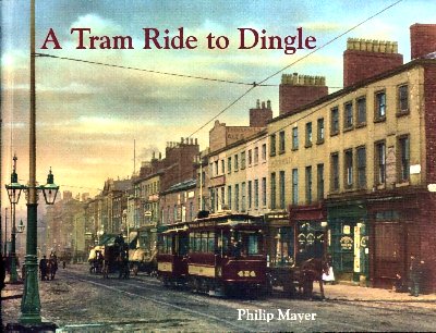
Front Cover: Park Lane
4. Tramway route map part 1
6. Tramway route map part 2
8. Liverpool Castle illustration
9. St George's Church c.1895
10. Queen Victoria Memorial c.1938
St. George's Crescent 1898 showing a Route 'A' tram (Dingle route)
11. The Custom House, Canning Place c.1885
12. The Sailors Home 1876
13. Park Lane/Canning Place 1900 showing The Custom House and The Sailors Home
14. Canning Place c.1900 showing City Biscuit Factory and Spekeland Buildings
15. 2 York Street 1928 showing premises of R. Ellis, Woodcarver and J. Reynolds & Co.
16. 149-153 Duke Street 1950 showing Copplestones Removals and B. P. Press Ltd.
67-85 Duke Street 1920s between Campbell Street and Slater Street
Wolstenholme Square, off Duke Street 1920s showing a Colour Works (paint factory)
17. 87 Park Lane Greetham Street 1924 showing Slack & Howden sawmakers
37-43 Park Lane 1927 showing shops including R. B. Potts & Co., sawmakers
18. Park Lane 1898 showing a tram and shops. This photograph is also used for the books' cover
19. Park Lane showing Kean's Hotel c.1980
103-109 Park Lane 1939 showing The Mayfair Pub (later Kean's Hotel), Criterion Dining Rooms, Mrs. Emma Williams Licensed Broker and Alfred E. Healing Pawnbroker
Upper Frederick Street 1920s showing Old Baths and Wash-house
20. Aerial Photograph c.1935 showing area from Paradise Street to approx. middle of Jamaica Street.
21. Interior of Kitty Wilkinson's Wash-house 1914
Aerial Photograph map guide (to previous pages' photograph)
22. Kent Street 1938 showing buildings opposite St. Michael's Church
Kent Street 1939 showing The World's End Public House
23. Kent Street c.1930 showing Bennett's ice-cream vendor (horse-drawn cart)
Victoria Terrace, off Upper Frederick Street 1934 showing court dwellings
24. Prince Alfred Cottages, Upper Frederick Street 1934
87-99 St. James Street 1934 showing a row of shops including St. James Post Office
25. Pitt Street/Greetham Street 1926 showing former pub and disused Wesleyan Methodist Chapel
Pitt Street tenements 1935
26. Upper Pitt Street c.1925 showing St. Michael's Church
St. James Street 1930s showing view towards the city centre
Aerial Photograph map guide (to following pages' photograph)
27. Aerial Photograph c.1935 showing area from St. James Street looking towards the Anglican Cathedral
28. Great George Street 1930 showing various advertising posters on the buildings
29. Courts, Rathbone Street 1920
30. The David Lewis Theatre showing a Poster, Building Interior and a Postcard
31. St James Public House 1993
St James Church, St James Place 1914
Petony's Buildings, St James Place recent photograph
32. Chesterfield Street/Upper Stanhope Street 1934 showing The Chesterfield Arms Pub
33. No.3 Court, Chesterfield Street 1934
No.3 Court, Upper Stanhope Street 1934
34. Cain's Mersey Brewery, Stanhope Street 1920s
Harrington Board School 1986
35. Beaufort Street from Parliament Street c.1920s
Grafton Street recent photograph (wrongly credited as being Beaufort Street)
36. St Patrick's Park Place 1920s
Upper Harrington Street, corner of Beaufort Street 1920s showing No.51 Beaufort Street
Domestic Mission, Beaufort Street, corner of Ashwell Street c.1890
37. Dickens Street 1911. Looking towards Toxteth County Primary School
38. 38-56 Hill Street 1934 showing corner shop run by Mrs. Lizzie Mitchell
39. Royal Southern Hospital, Hill Street/Caryl Street c.1900
The Little Woodman Public House 1935 at 3-5 Hill Street
40. Caryl Gardens 1938
41. Playground inside Gardens showing swings, rocking horse, roundabout, witches hat etc
42. Warwick Gardens 1938
43. Playground inside Gardens
44. 66-84 Upper Mann Street 1934
45. Grafton Street 1934 showing 121 Grafton Street
46. 123-139 Grafton Street 1920s showing St Thomas's National School building
The Eureka Hotel Public House, 20 Park Street/Beaufort Street c.1955
47. The Park Palace, Mill Street 1982 showing the building when used as a Chemists' shop. Also shown is Park Street Chapel
Park Street/Mill Street 1925 showing Park Billiard Hall and The Chester Castle Pub
48. Domestic Mission, Mill Street c.1970
Grove Cottage, Mill Street 1920s
Aerial Photograph map guide (to following pages' photograph)
49. Aerial Photograph c.1935 showing area from Sefton Street to Mill Street
50. South End Mills, Mill Street c.1950s showing Windmill
Great Eastern Public House, 44 Harlow Street/Mill Street 1992
51. The Florence Institute, Mill Street 1906
Mill Street from Haylock Street 1969 showing the Florence Institute and The Derby Arms Pub
52. Grafton Street 1996 showing junction with Harlow Street
Ruins of Mersey Forge 1920s
53. 323-329 Grafton Street and Court No.25 1956
54. Beresford Road 1920s showing house No.192. Also shown is part of St Paul's Toxteth District Orange Hall
St Cleopas C of E Primary School, Beresford Road 1969
55. Park Road/Northumberland Street 1986 showing the Welsh Congregational Church and Coleman's Fireproof Depository
Another photograph of Coleman's Fireproof Depository
56. 92-82 Park Road 1920s showing shops near Northumberland Street
57. High Park Inn, 187 Park Road 1982 showing The High Park Pub and Farmer Arthur's shop
The Crown Vaults, 120 Park Road 1992
58. High Park Street c.1920s showing Public Offices, Reservoir and Mount Carmel Church
St Silas Church, High Park Street 1920s
Beresford Cinema, 244 Park Road showing Poster (Cinema not shown)
59. John Hughes, Grocers, 274 Park Road c.1910
60. 315-357 Park Road c.1898 showing shops and men laying tramlines
Park Road showing Demolition of some shops near Dingle Pub 1990s
61. St Paul's Church Institute, Miles Street 1920s
Providence Buildings and Industrious Terrace, Miles Street 1920s
62. Park Hill House 1920s showing the mansion and oil-storage tank
Park Hill House
63. Shore Fields c.1900 showing the view over Herculaneum Dock
St Cleopas Hall, South Hill Road 1920s
64. Parkhill C.E. School, Parkhill Road 1931
The Dingle Picturedrome, Park Road/Gredlington Street showing Poster (Picturedrome not shown)
65. Gaumont Cinema, Park Road/Dingle Lane 1937
66. Kedleston Street/Park Road 1926 showing advertising Posters
67. Dingle Station, Park Road c.1900
68. Dingle Tunnel, Overhead Railway c.1900 showing tunnel at Herculaneum dock
69. Park Road from Dingle Station c.1900
70. The Ancient Chapel of Toxteth, Park Road 1920s
The Dingle Tram Shed, Ullet Road 1899
Inside Dingle Tram Shed
71. Roscoe's House Ullet Road 1920s
51 The Elms and Grosvenor Terrace 1920s
72. Ullet Road c.1900 showing a tram
Toxteth Congregational Church, Aigburth Road 1920s
Parkfield Lodge, Aigburth Road 1920s
73. Aerial view of the Dingle
74. Aigburth Road c.1905 looking towards Ullet Road
The Dingle 1920s showing the area prior to where the allotments are today
75. Bed of the Dingle 1920s showing Turner Memorial Home
Kinnaird Street 1909
Rimmers Farm, Dingle Lane 1920s
76. Shorefields Comprehensive School 1938
West Dingle, Dingle Lane 1955
77. Mathew Arnold School c.1970
78. Dingle Bank Cottages c.1910
Promenade recent photograph
79. Dingle Point c.1890 showing area of the Cast-Iron Shore or 'Cazzy'
Back Cover: Old Liverpool Castle illustration, Electric Tramways Sign illustration, Toxteth (Ancient Chapel) illustration
There are not many books which cover this area of South Liverpool, so this is a very welcome publication. It has a nice collection of B&W photographs covering 100 years. It's fascinating to discover which buildings still exist and have escaped demolition. How long Park Street Chapel, the Park Palace or the Florence Institute remain is anyones guess, as they have been neglected for many years. A short history on the origins of Dingle is contained in the book which makes this an essential purchase for anyone interested in the Dingle Lane, Park Road and Mill Street area.