The Pine Creek Trail is about 55 miles long (as of the summer of 2005) in the north central Pennsylvania counties of Tioga and Lycoming Counties. It goes between Ansonia, PA and Jersey Shore, PA. The first time we rode on it in 2003 it was only about 45 miles long and ended south of Waterville, about 10 miles from Jersey Shore. We rode on it again in 2005 to lcover the new part and repeat some of the old. We are from New Hampshire, but made many trips to Pennsylvania to ride the many beautiful trails in that state. After riding on many eastern rail trails, we think this is one of the best.
Click her for the PA State site for Pine Creek Trail. Clicking on the Trail Info Contact button explains how to request a map, the Photos button will show pictures of the northern part of the trail, and the Trail Website will get a description of the trail.
There isn't a detailed map of the trail to view on the internet. To get a map send an email to the Tioga State Forest Office at: [email protected]
or click the Trail Info Contact button. The information is not up to date; the current trail map shows the trail as 40 miles long between Ansonia, PA and Waterville Village; however it has been extended about 10 miles south of Waterville Village. The southern most access point is called Whitetail Access which is on Rt 44 about a mile and half mile north of Rt. 220. The southern end is at Jersey Shore, PA.
There are three campgrounds along the trail and primitive camping is allowed on some sections. Permits are required. Send an email to [email protected] or write to:
Tioga State Forest
One Nessmuk Lane
Wellsboro, PA 16901
There is bicycle and canoe rental and shuttle service for a one way trip on the trail at Pine Creek Outfitters.
Click here for some information about camping, accomodations, restaurants along rails to trails. Click on PA to see the locations of Pennsylvania trails and then on trail 8 for the Pine Creek Trail. It also gives some info such as surface, elevation change and has a small map.
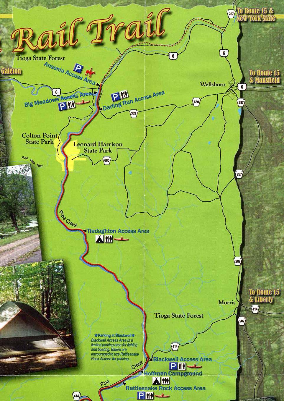
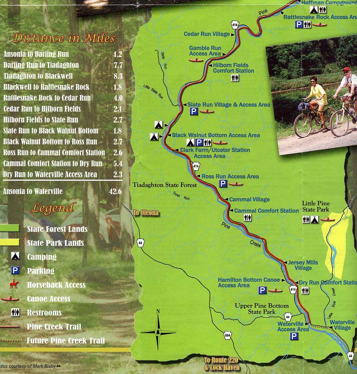
Since there isn't a detailed map on the web (at least I couldn't find one) I copied the map in two parts which can be obtained from the address above. The latest maps just show the part of the trail between Ansonia and Waterville.
Here is a map of the northern 20 miles of the trail between Ansonia and Blackwell, PA copied from the state map.
Here is a map of the southern part of the trail copied from the state map.
The first time we rode on the trail, we made a round trip of 40 miles one day between Darling Run, near the north end and Rattlesnake Run Acces point, a few miles south of Blackwell. This is about the midpoint. The trail goes a mile or so north of Darling Rund, but this part isn't as interesting as going south. The round trip between Darling Run and a few miles south of Blackwell to Rattlesnake Run is about 40 miles. The next day we started at Rattlesnake Run and Made a round trip to a point about 4 miles south of Waterville Village which is another round trip of about 40 miles.
In the summer of 2005 we rode on the southern part of the trail ending at Jersey Shore which is the southern end. The entire trail is beautiful, but the northern part where it is located along a fast moving stream between steep mountains is more spectacular. In the souther part the trail is still close to Pine Creek and there are several bridge crosssings. Instead of the trail being located between to steep ridges it is more open and there are great distant views of hills. It goes through some pleasant farm country and pases thorugh some small villages.
Here are some pictures of our trips on the Pine Creek Trail.