Here are a few pictures of the trail.

The Massachusetts Department of Parks page for the Nashua River Rail Trail (NRRT) trail has information for use of the trail, a clickable map, locations of parking and bike stores. These descriptions are for the trail ending at Dunstable in the north and don't show the new extension.
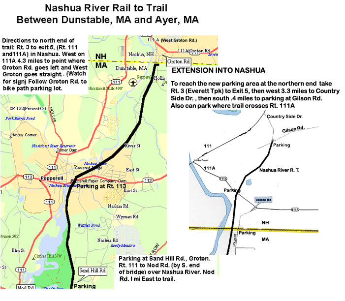
Click here for another printable map of the northern half of the trail which shows directions to the parking areas. This map shows the new extension and parking areas.
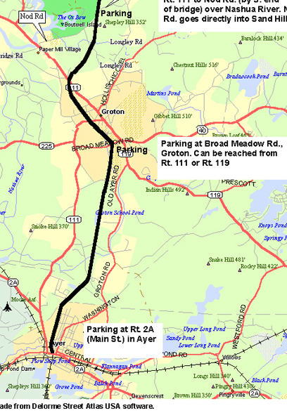
Click here for another printable map of the southern half of the trail which shows directions to the parking areas.
We enjoyed riding the trail in both directions, but found it more enjoyable to ride it in one direction and return by road. Here is a description and map of the road route. These maps show the NRRT in black and the return road route in blue.
The trail is close to the Nashua River for only a mile in Pepperell but because it is the river valley there are many relatively undisturbed wet land areas. Because of this the trail looks rural except for sections in the center of Pepperell and Ayer and along the edge of Groton. The country look of the trail is really noticeable when arriving at the parking lot at the northern end in Dunstable. The trail starts its journey through the woods a few hundred feet from a suburban area of Nashua.
Nice features of the trail are its smooth paved surface and the small number of road crossings, only eight in eleven miles and most are quiet roads. Use care crossing Rt. 113, the busiest crossing, where the path crosses near a road curve.
We enjoyed passing through the Pepperell business area which has some homey Rails to Trails touches. There is an ice cream place called "Rails to Trails Ice Cream" attached to a restaurant and there is usually a portable hot dog stand set up along the trail. There is another little refreshment stand set up along the trail about a mile north of Pepperell. There is bike shop right by the trail at Rt. 113 in Pepperell and a restaurant across the street from the trail. There is another restaurant a few blocks west of the trail on Rt. 113. The Pepperell Covered Bridge is less than a quarter mile west from the Lowell St. trail crossing.
The trail doesn't go through the business district of Groton but it is a short way to Rt. 119 from Broad Meadow St. which the trail crosses. There is a small restaurant along Rt. 119.
Ayer has a few close by restaurants; there are two on Main St. (Rt 2A) a few blocks east of the end of the bike path and a pizza shop on Park St. (Rt. 111), a few hundred feet from the parking lot. There is also a bicycle shop on Park St. about a half mile north of the parking lot.
Here are a few pictures of the trail.