To next page
Ibn Madjid
First navigational poem. (As-Sufaliyya)(1470) (the poem of Sofala)
--------------------------------------
Taken from: Chumovsky,T.A. Tres roteiros desconhecidos
G.R. Tibbetts 1971 Arab navigation in the Indian Ocean before the coming of the Portuguese
Ibrahim Khoury: Ahmad ibn Majid al Sa-di, fl 1462-1498 ; As Sufaliyya : the poem of Sofala / by Ahmad Ibn Magid; Boletim da Biblioteca Geral da Universidade de Coimbra
H. Grosset-Grange; La Cote Africaine dans les Routiers Nautiques Arabes au Moment des Grandes Decouvertes; Azania 1978
H. Yajima: Some problems on the formation of the Swahili world; Seuri Ethnological Studies nr 43
H. Grosset-Grange; Une carte nautique Arabe au moyen age; Acta geographica 1976
-------------------------------------------------------
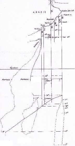
The drawing left taken from Grosset-Grange is a reconstruction of a medieval Arab map of East Africa based on the figures given in Ibn Madjids work.
The pictures shown under here and the text in red do not belong to the manuscript of Ibn Madjid. They belong to Theodore de Bry of Frankfurt who made them 1598-1603. And they represent some of the earliest drawings of East Africa from Europe. They are added here as illustration only.
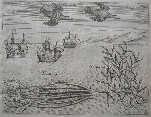
Seaweed and more birds seen [approaching the Cape of Good Hope] during the voyage to India
The sailors saw many plants floating on the surface of the sea during their voyage to India. Among these was the trombas, which was a pipe-like growth with its roots floating free in the water, also the Sargasso, which was a large seaweed with pointed, serrated leaves. The birds included one which was black and white, with a grey bill. The sight of this bird, along with the trombas, was a sure sign the ships were approaching the Cape of Good Hope.
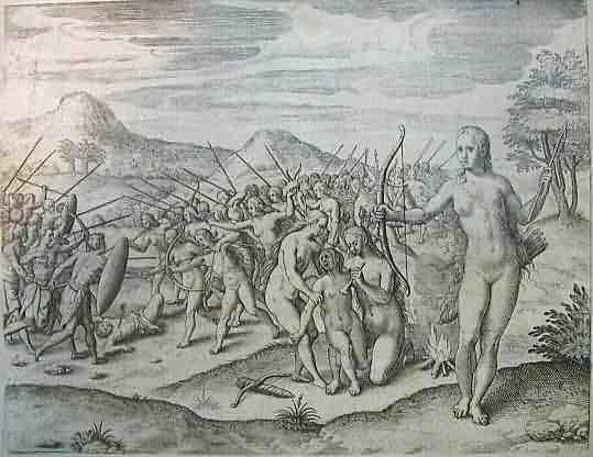
The women of Monomotapa
The best of the legions in the emperor of Monomotapa were women were trained to fight from infancy and had their left breast burnt off, so as not to hinder them when shooting with their bows and arrows, with which they were very accurate, just like the Amazons of Amazonia. These women were strong and sturdy and lived in their own territory, which was given to them by their emperor. At certain times they went off to visit the men, picking out whosoever they chose. When a warrior woman gave birth to a son, the son was sent to live with the men-folk, but if she had a daughter, the daughter was kept with the women and trained as a fighter.
-----------------------------------------------------------------------------------------------------------------------
Ibn Magid wrote 40 works of which 39 in verse. Some are brief, but the Al-Sofaliya is 805 verses, and the original version must have been 701 verses. The rest are later additions, many concerning the Portuguese. It describes the sea route from India to Sofala. The original text dates from 1470. The additions are situated to 1500 (but can be added even way later).
His Sofalia, lost until the middle of the 20th century, was the guide and textbook for Arabic knowing sailors to help them negotiate the East African coast.
I translated the complete text from Portuguese (the translation of Chumovsky) and corrected it with the translation in English by Ibrahim Khoury and the different articles mentioned above. A lot of the text is about astronomical measurements. My text does not pretend to have those translated without error. No explanation is given so as to understand the navigation of the Arabs. The basics is that they measure the height of a star above the horizon in fingers (isba). For more information read: Arab navigation in the Indian Ocean before the coming of the Portuguese
In front of every page first an abstract is given of the page. Some of them I wrote myself. Many are taken from G.R. Tibbetts in his description of the route to Kilwa. Which he also translated (summary) from the Sufaliyya. Note the - to many- differences between the translations.
Introduction and the route from Calicut to the Fal islands. (Laccadive)
(Folio 83 recto)
On behalf of Allah, the good, the merciful.
Glory to Allah, Lord of the worlds. Blessings and peace on Muhammad, His descendents
and His friends. This poem (urdjuza) is called: The Poem of Sofala. Its usefulness
is in the education of courses (of harbors and landmarks) and of measurements (astronomical) of Malaibar, Kabalan (=Concan), Guzerat, Sind and Atvah, who tie the as-Sif at Tawil (= the Long Coast), and to the as-Sawahil, Zandj, Sufal land, Kumr and its islands; (also in this script are) of the rare, things relative to all the currents, that one finds in these regions, until the southern point of the continent. They also give the measurements that allows the navigator (mu' allim) to recognize the decrement or accruement (of the stars) in all their places (hann). It becomes the science of the extraordinary phenomena's, in this way, relative measurements, regions of the Earth, descriptions of the inhabitants of these lands, its sovereigns and the monsoons. Navigating, as they do in these regions, had allowed these navigators to discover new things. It was the place (later) of three (pilots), and the admiring pilgrim of the two Holy Mosques and noblemen Chihabaddin Ahmad ibn-Madjid that Allah fortified with His grace. Amen, amen. (the three pilots are Ibn Madjid, his father and his grandfather.)
Glory to Allah, the not-being created, the un-measurable. Either praised, either feared, either exalted. Language spoken in compliance with the words that give the description - how many things to see in the sea!
Through Him one is not empty handed, in the measurement and routes that we follow in the early dawn, from the land of Calicut to Dabul, Guzerat, Diul and from there, later, to Hurmuz and Atvah (following the workmanship of the Creator, friend) until the as-Sawahil and regions of Kumr (Madagascar), and until Sofala. In all cases measuring and sailing from the land of Calicut until ( the islands of) Fal, following (the star) Djah (Polestar ) at 2 going up to 3 fingers. Your navigate according to Djavza (Orion), and with Tir (Sirius), you must be satisfied with the vigor of the wind during your trip. If this wind is not contrary, and opposing, all the way that you cover so it will be clear, regular sailing going by Kaffini. Count, in total, 20 zam (each zam corresponds to three hours of navigation); on this route this wind is called Magrib (West). While on the Fal islands this wind drops, the right one is Fal and of the left is called Kit al-Huzn (in Arab, Fal means: good prediction; Kit al-Huzn: metaphysical way to say that in an archipelago one has two opposing islands) If your wind blows from the West to the region of Marib, against your ship, or the sea is hot, or it rains, these are phenomena's that alternate and happen on the trip. What matters is it to give to a pilot the description of the route or that of his life? Go up and down and find the good wind. Think about this and take your decision. Djah does not set, go to the north if it (the star) does not reach 3 (fingers), according to kamal (the measuring instrument). Enough to have the instrument to measure on the right hand and its pointer will show you the sea-lane.
(Folio 83 verso):
The island of Kaffini, estimated with the eye. The evidence is that Ramih (Arcturus and Hamal), these stars in the East, go up to 6 nafs (unit to measure the space between the stars). And when measured and it does not reach 6 fingers, then you must stop in a shelter of the island Malaki, because of monsoon rain. When in the rain, let Djah settle in the height (where it gives rest of the disease of rain, the heat and the monsoon in the travels), sail following Simak (Arcturus then Vega) (later Djah goes up until coming close itself to 1 entire finger) you reached already Makudji and going to Guizirat or you directed yourself for Zufara or Kalhat.
While when going for Zanzibar, the dominating wind on the trip is the monsoon that is the one that blows already the seventieth (days of Niruz) (Iranian solar calendar) that is during the start of the trip; on day 80 you will enter (in the port). There the navigator who is going (to this place) in the 90 day (of Niruz) will not be able to enter except in the special years.(when the winds are different from the average). But if you hoist the flag of the Fal (Laccadive) islands, and your direction is for Zandj - then hear my instruction. Sail according to the routes of the setting sun and Djavza (Orion star) (10/24 route of the winds-rose of the Arabs) for the as-Sif at-Tawil (Long-coast), and sail to the land following the route. You will find here Suhail (Canopus) and Zalim (Achernar) at 61/2 (fingers) -- know this. If you find out that the measurements from the kiias (instrument to measure the height of the stars) are not exceeded, go west without fear. Later you will see the two Charat (Ari with Mizar) in the setting sun, together with the sixth (star) Nach; my experience tells me that! They are 4 fingers in kiias (measurement). Together with the increase 3 of kiias she also increases, (rapidly), during the navigation to the long Coast - you know of bachi! (this is the rise of the Polestar relatively to its minimum height above the horizon). You will not sleep one night during this trip - a great error is not pardoned. Here is the land, its sign are the birds ( al Munig): you must always consider them as unalterable rescuers. He is tired that (bird) that is found (bird) 20 zam away, o navigator. If you see many saving birds, approach with prudence to the land, you will enjoy salvation. Each navigator who governs a boat knows the things and knows to observe. He knows many varieties; of hurnub ( or Garbub) (Foetida Anagyris) of the birds, fish and currents, o my assistant! If: to leave of the land of Dabul, follow my descriptions, accept my word.
The Tabkat Atol of Mukbil.
(Folio 84 recto)
Sail for it by the setting of Tir (Sirius) (of Galgos), until the position of Djah is such as was described, because it does not diminish and it does not increase. Follow the direction of Iklil ( Scorpion) with security: following it you will sail for as-Sif at-Tawil (the Long Coast), and the navigation will be in complete security. The limit is the Tabkat atol (chorale island) of Mukbil, you continue, if you do not see the continent, it is because you enter in the deep sea and the wrong course, since you are one of the knights of this sea. Its signals are described above. Here is the clarification about the measurements of the positions (of the stars), (experience is in all places an advantage for the man that travels the sea, o navigating one): here is the first - Charat (of Aries) is mentioned, the two to it (Beta and Gamma) and the Inak (Mizar) (the medium one of the three lateral stars of the Big beer): the regular position for measuring them is on all horizons; but in the lands of the Zindj they are not usable. I mention them, and others in my descriptions. Still the distances (of these stars) in the high land is: in Dabul similar to the one of Djah (Polestar), that is 8 (fingers); it is this one that is similar for all these stars. Each time the distance of Djah diminishes 1 finger, the distance of other stars diminishes by a half. Measure them and list them. If the measurement that you take becomes 8 (fingers), then to be convincing also use the wire (measurement). You will know that this Inak is put in front of Djah and is used like it. If you always measure 10 for Djah, your measurement of this bright star - (Inak) will accordingly show in Mahaiam (region in Konkan) 3 entire fingers on the scale (of the instrument) and each time that the distance of Djah diminishes, calculate the increase for this star for one finger, with a sixth part of the finger diminishing (for the other star); I measured this with precision. While to the star Bar (Aries), it does not diminish and it does not increase: it has 10 fingers. You can use this to your advantage. It is measurable in all the places of India. 0 my end is here to make known the rules displayed. With the measurement, however, of the flashing star (Inak)as reference, it will decrease Bar (Aries) in the sky 3/4 fingers, at every headland. Do not forget the rules of the measurement science, know that Bar and, beyond it, also Mirzam (Tir of Galgos) 7 fingers from the North star - this in a regular measurement. But in the setting sun these stars (Bar and Mirzam) have eight divisions according to the scale (of measurement). Measure this and it counts.
( Folio 84 verso)
Each time that you observe the decline of Djah, you will see decline Bar with 2/3 with all (its stars). I talked about them in this poem, according to my experience. Your measurements concerning Aiiuk (Bar), will be around 8 fingers. Mirzam (Tir) increases 3/4 fingers with a tirfa (or Tiriffa)(coefficient that indicates how far it must go to change 1 degree of height), o my assistant.. Measure Makil and Murabba (they are known to the master and me), when they enter in the culmination of the Gurab star until the last star of (the constellation) the Ava, indeed. (Gurab) is found immediately when it is in line with Makil, but direct in front of Zalim it becomes invisible. Murabba is at 3 fingers and 3/4 at al-Hadd. (It fits) in the limits of the four (stars) of the quadrangle (of the big bear) and its southern star is placed, by times, above it. The measurement gives to it 7 fingers and a half; the main star is the one that is in the center (Gurab). Measure it and list it, follow it and tell (the result) to all people. This star belongs to the ones that is 9 (fingers)and a half (it is known) at Mami. Measure Kalb, later Makil, it will be necessary to count 4 (fingers) above to Mahaiam, until, o careful man, you find the inhabited land (where) Djah will be 6 1/4 - accept the measurement! Kalbs position measures 4 fingers; and that of Makil is known - the decline is noticed: he is 6 (fingers)and 1/ 4, as an initial comment; measure it and list it. It is truth: on the measurement of the stars that go up and go down can be argued. Its measurement tires to dead; the specialist, the methodical scholar only knows it, exactly when if she relates only to this Long Coast, I want to say to the land of the Zindj, my friend. I talked about it (of these measurements of the stars) so that you know the spheres and the course of these pure heavenly bodies. Measure Makil, later Kalb according to the scale (of the instrument), and admire the workmanship of the Lord: (when) you measure Djah 6 1/4 (fingers), they (Makil and Kalb) are 71/2; it makes some of these facts understandable. Above Mahaiam they can be 4 (fingers), but Djah is invariably 9.
Midvar promontory, Samnat then the African Coast; first Djirich to the North of Hirab (region of Somalia) the end of Hirab is in Djarbil promontory. Then a range of ports all in a two day distance, also Socotra.
(Folio 85 recto)
So they increased with 31/2 fingers. Measure this according to the indications of my description. If you measure Kalb and Zalim at Zagad it will always be 4 (fingers) (in this case) plod to sail following the first one; and Kalb is recognized according to the movements of Makil, to interpret them no movement of the mentioned Makil and Muribba is seen in fingers in Djah, but this is modified in all the latitudes with 1/4 of finger, that way you have to regulate. When, on the other hand, the Tir star is your reference it will decrease Aiiuk in its course: then the height of each star is modified with four units. Both (these constellations) are in the West, o captain! In the same way, when the rise of Aiiuk is ended, Tir increases (this is certain). Test them. Your experience will enrich, thanks to it, steer not to the land on them, o observing one. They (these stars) are above of Mahaiam, as is described: 2 fingers, but add 1/2, when you measure Djah 7 (fingers), Tir will be 5 and a bit. And Bar does not decline, does not go up, its stand is 2 1/2 fingers, o praised man! Know the bases of science to measure and do not communicate it to all people. If you leave from Midvar promontory (Ras Madwar), for Samnat (Sumanat), sail with prudence and keep monitoring. These ports are good to enter, and later to leave, as the experienced say. Leave these ports with the diminishing of Iklil and also Akrab in the direction of the end of as-Sif at-Tawil (the Long Coast).
Djirich (Giris) is the port where it (Somalia) starts, to the north of Hirab (region of Somalia). Do understand my list. Hirab finishes, o navigator, in Djardil (Gardil); But at 11/2 finger for Djah there is a promontory similar to al-Hirab; it follows my description. If you delay at the beginning of the al-Mariza (a kind of fish sign of approaching land) one or two days, then you sail following Iklil, navigator, and remember what you forgot to calculate.
You follow the coast (underneath Iklil) and of course, the continent is always present.
Is it necessary to repeat? Look them up you have the data. Notice the increase (of degrees) for the way back, notices them in the way for use on the land. Measure Markab you shall reach the back of Socotra and its coast, Farg al-Mukaddam (Handles of the plough) you will find in the south when Nach (Polestar) has 5 fingers, follow, that admirable shelter! While to the name Farg, (of Markab)it must be written (o man) with a Gayn thus said ad- Damiri (we cannot doubt his words),
(Folio 85 verso):
in his - commentary for the "Used Way", o navigator. Later, on in the book we learn, and we observe with evidence that the Fish (Hut, sign of the zodiac) is together with the Womb of the Fish (Batu al-Hut in Andromeda), o friend! On the scale of the instrument they show 51/2 fingers; my description is in agreement to the comments made for the coast of Socotra. But it happens that Batn al-Hut and Furad (of Hidra) are 4 fingers there. In Guardafui they move from their places; they circulate in the East and the West. Observe them in Guardafui where they are interchangeable and also Djah (Polestar), in the West and the East without making confusion. But Hut extends to the setting sun during this monsoon, o my beloved! This is the knowledge that follows the nomadic navigator; necessary to them. Measure Ramih (Arcturo) with Suhail (Canopus), in front of Guardafui: you will have 10 fingers, o friend! Djah and Farkad (of the Lesser Bear) is ahead of you these comments are good and certain in their use.
When measuring Suhail and Zalm, you will see them equal to Djah, o equal expert. At 4 fingers; observe them (these stars) and hold back this explanation as a zealot. If you follow my description in the promontory of Guardafui, and later in Hili, you will feel as if tasting pure wine. When in parts of the land of the Sind going to Zandj, experiment with this, without recklessness, cross the deep sea: on the western side you will have Himar, later Akrab. When approaching Socotra they advance. Approach on a western course, o my expensive one! Continue steering on them They continue from there and turn for Iklil. 0 your way is long; practical navigation and the sustained experience will follow you, one after the other. Continue following Iklil, for the coast, where the cities start. Here you will find easiness calmness and security. You will see Suhail here, later Makil: at 8 fingers. Observe them, o man who lives long! But Kalb (of Scorpion) and Aiiuk (of Aries) are to be seen at 3 fingers in the sky and also you see Chami ach-Chami (Polestar), and Vaki (Vega of Lira) at 41/2. Listen to me! If you see that the directions, my comrade, made in this way, are correct and if you are suspicious of the clear water sea (he wants to say, ports of the Coast), measure here (the distance of) (two stars) Simak (of Virgin) and remember them. Velas (the Simak stars) with evidence. They are at 6 fingers in the East. Its rise in degrees does shall be noted according to the sailing distance during the trip. Take care of them to be successful. And you will have the test during this navigation about these rules and you will not forget me.
The coast of Gubbat al-Hachich. Lots of astronomical measurements.
(Folio 86 recto):
I described them in one other urdjuza; but still they are important here. Measure Kalb and Zalim with the North star at 7 fingers; they are 4 fingers there is Aiiuk and, later also Mirzam (of Galgos) with 31/2 fingers. Observe and know them. If you look together at Kalb and Makil you will notice six divisions in the kamal (instrument to measure the rise of the stars). While the Murabba and Zalim, are at 71/2 fingers; where the pole star is at 7 at the coast of Gubbat al-Hachich. God protects from dirt and misfortune in it. Tir leads to the setting sun with 4 fingers; Aiiuk is 3 fingers here, according to experience. Observe (the stars), to the left and the right: when the knot (of the instrument) is to the left the pilot sees on the right ( the star of) Zira (of Gemeos) an increase of 1/3 finger in tirfa (or tiriffa)(the latitude equivalent that corresponds to an modification in the height of the polar region of 1 isba is 1 deg 36 ' 25") verify this. In a similar way, with the decrement of the left (star of) Zira, the knot (of the instrument) will be on the right star. Do not argue. You learn, o captain, his characteristics: for the polestar 81/2 fingers; For Chami ach-Chami and the Vaki star the measurements are equal to the initial rules; it uses them. Here you will find Chir Gumaisa (Sirio) 51/2 fingers and further, they have not diminished. It notices the reduction and the increase in Chir and Zira according to their custom. Its custom for each head to half a finger. Useless to continue the description! The two Simak, with pole star at 9 fingers when they are born. They are both with me, 6 fingers is Azal (southern Simak), while Ramih (northern Simak) is 5, this is clear and evident. And when the height of Djah diminishes with 1 finger, Azal increases by half, and 1/8 - you make a knot in the rope (of measurement). But the measurement of Ramih is always 5 fingers. We do not observe them for the navigation, but it is necessary to mention them, in my opinion, o my brother! Because I do not leave a star in the sky unmentioned if in the manual its name appears. But do not have doubt of the measures of the height of Ramih and after of Azal comes Suhail, when it is fixed with the knot (of the measuring instrument). With the pole star at 9 fingers, as it was established. For Ramih the knot indicates 5 certain fingers. But Suhail can be 2 zubban and 1/4 (1 zubban=4 isba=fingers 6deg 28 '). Understand this reality.
(Folio 86 verso)
Every time that Djudaiia (of the Lesser Beer) declines 1 finger, Suhail grows, listen to this, o my brother!
It grows 3/4 fingers - my commentary is exact. Ramih follows the same measurement it is according to my descriptions. If, in a particular case, (Suhail) will be 7 (fingers), in the same time the pole star (Ramih) will be 7. Curious fact. Later, this is certain, the height of each star increases with a half and one tenth, you shall remember of what you have observed. All these stars Suhail (Canopus) and Ramih (Arcturo) -- they are luminous. Accept this truth. You see the pole star at 51/2 fingers Murabba is visible ( square formed by the four first stars of the Bear). Note it according to my description; While the Zalim ( Eridan), is 7 as usual: it does not decrease nor increase. And Djah diminishes. Up to 21/2 fingers. Here (it can be counted) 1 zubban to the stars, Murabba (the square formed by the four first stars of the Bear); I speak of the measurement up to the water horizon please listen! In similar way to this is Ramih (Arcturo) also 1 zubban. Disclosed is this science, Pilot. (Nobody) needs a repeated description, except a stupid one that is one that does not possess anything with two eyes. When omitting Farkad (of the Lesser Bear) in its rising, when the high Sarfa is in the top you will have to notice Farkad in the zenith in Ahvar (or al-Ahwar)(port of Aden) without positive error. Its original measurement at al-Hadd is 211/2 fingers. This is the regular process (to measure), my brother, verify it for the experience; a process to which I really can give credit. If verified it finger for finger. I measured it 1 zubban in al- Hadra island, (island to the north of Zanzibar). I come back o navigation of al-Atwal, brother, toward the so prosperous region of Kalhat. Then, sailing leaving the land, along the shore for Ras al-Djamdjam (al Gumguma) watch out for the plants (without this you will delay). In sailing follow Suhail - this and a support - of the eastern side of this promontory for Masir, will bring you following Akrab in the direction that you want, you sail and you calculate. If this occurs (calculating according to Iranian (solar) calendar ) at the 90th day of Niruz beware of winds in your way when it rains unendingly. Cross not the sea at the beginnings of the currents of air. Cast the anchor and decide to stay. Now you passed where the harbors start. Take information and decisions with firmness. If you want to come back towards the high sea, turn, and you follow your intention and you sail. Cross the sea from Zafar following Suhail: you will see Socotra, who will guide you. When you leave from this island, a good route follows Muhannis. Such routes, o my brother, are created for the travelers. You will see Socotra on the left side, turn following Suhail if you are afraid of the water that might poor into the ship stay to the coarse (and close to the coast), and follow, in the same time, the main road, until the road starts that goes to Hafuni. But whoever traverses the islands directly by the setting of Suhail reaches the back of Samha and Darza. Beware of the islands harm.
After clearing Socotra one sails SW by S and then SW to reach the African mainland at al-Tabaqat or Saif al-Tawil and from here, one takes a bearing SSW, SW or SW by S to Mogadishu and Brava
(Folio 87 recto):
Leave the sea-lanes of Socotra, when crossing from Zafar leaving the island at your right hand side till it disappears in the maritime horizon, till you can only see it in fine weather, that needs time, clearly these roads extend a long way. Proceed according to your experience, friend. When you move seawards of Socotra Himar takes the way, and leads you according to Akrab (of Scorpion), navigator, until you are surrounded by the Tabakat land in the limits of Djirich (Giris) - use my description! And then there is Hirab of the dangerous reefs, this Hirab (locality in Somalia) it is next to the sea (accept my speech), but, that Hirab, is nearer then the region of al Hirab. In Tabakat you will find the Ramih star; it is 5 fingers according to undisputed measurement. If you arrive at as-Sif at-Tawil (Long Coast), you find this land, whose clean way is not difficult. Take your decisions and consult an intelligent, local guide, one that has the knowledge. You get what you want, o new, ignorant subject. Then from as-Sif at-Tawil until the atoll Mukbil the Coast is clean, very clean. The coasts go up under the form of sand hills... Study its description, o pilot. You follow for a while the hills, the land deviates to the setting of Suhail. It is necessary to know this. The sand-hills spread in the direction of Akrab and Himar, and all over the interior, but the atoll (of Makbil) comes and at Muruti you meet a hidden reef, covered by the water, o my beloved! Muruti is a reef separated from the land, that surrounds the navigator who approaches and wrecks them- note here what I say! In the majority of the cases the navigator, does not see, nor it, nor atoll, but they feel it, they are next to the continent, and two of its extremities, stick above the sea. Past Muruti sand hills are found until as-Sanani; listen to my narration. Al-Murit is 11 stretched arms deep stay away. At times you see here a small mountain extending inland. It is close to the coast; then there are reefs till close to Mogadicho. You see the mountain not during the rain or in t he dust. It has the name Hirab in Arab; in the language of the Zindj it has a bad name. It is necessary to see it, but not to know its name. Sail to Mogadicho and to its region; if you want, you enter there, or it directs you, to Mark (port in Somalia), and, later to Barava. Pray you will cross the mountainous plains in one day.
(Folio 87 verso)
Barava is distinguished by seven hills, through which you see its port. Its fourth hill stands above it. On all the sides the hills are abrupt. Enter the port, where you will be sheltered from the elements of the sea and their influence. In the south of the port (Barava) you see an island isolated, high and vast. It is closed to all the winds, as the experts say. Perceive its description and do not argue. Go around part of the island and enter the harbor. The people will come to meet you before arriving here.
You start sailing with aziab (the SE wind ); if you want to enter there, make preparations. You do not want the port, you can sail on along the coast. The land of the people ahead goes on until the end of Sofala (that is the news I give you), until the end of Sofala, pilot. You must have the knowledge, ignorance brings the worst results. Sail according to Iklil (you do not contradict me) for the interior coast of Chika; this coast is known. The first thing that you find in this gulf is the island of the region of Djubb. You sail to there, 4 zam entirely and full, with the wind aziab. From (the island) until Malavan also 4; keep to my verse and keep the attention. From there, 6 (zam) distance, and here is finished the region coast whose description is specially described and each parceled out in sand. Here is Bata, to the south of which you find the island called: faza ali "That Ali Prospers' and known thanks to this last name. Between the island and the continent is the way. On the ocean side of the island is the reef, but close to the island you find that where she is it is necessary to redirect the course; it is up to close to Vazina (where?); the continent is inhabited by tribes, as in Sarik, o careful man! To the south of them there are innumerable small islands, later big ones, o wanted. They are extending from Malavan until Bata. The ones that are in the sea-lane are of equal dimension. The land of Bata is a city of generous people and the cats called al-Zabad. And to increase the news on this land, you will make measurements that are clearly known. Above Barava you observe Farkad 4 (fingers), as the Sarfa (of Leao) - exact as an indication. The greater Farkad, in the zenith, has a height of 8 fingers and more, without error. The same as above for Djubb it has 71/4. In the region of Malavan it is certain that its position is equal to 7 less 1/3. When you measure it, you will know the way. And when you measure the greater Farkad you know its zenith 6 (fingers), and a half -- its position in Sarik country, and later in its islands, is known. 6 less 1/4 in Bata. 5 1/2 exactly. Equally in Lamuh and Kitava measure it and remember you of what you read.
The channel to the Lamu archipelago.
The route then is SW or SW by S as far as Wasini and the coast disappears in a bay to the right (Formosa bay) Here is Shikala (Shaka?) and the island of Zalwilul (Mwamba Ziwaiu) . Cape Kiluma is next and the bay over Qilimane, the bay starts at Shaka. Kiluma the end of the bay (Ras Ngomeni).
(Folio 88 recto):
Is it necessity to explain to the reader the position (of Farkad)? For love, for pious love of science, it is known: at the beginning of Ras al-Hadda (promontory in SE of Oman) it starts with 21 (fingers) and a half, use the graduation (the measurement) for Ahvar (port of Aden) finger for finger for each tirfa, (coefficient that indicates how far it must go to change 1 degree of height) because (Farkad) is above the polar and has here no error or deceit only measuring to wide and to narrow; I tried this, and confirmed it through observance, with certainty: He is 4 (fingers) plus about 3 strait on. While its height in Hadra, is even more approximate. If you do not see Farkad in the previous measurement, and you are having difficulties, measure the height of Farkad according to this description, together with the two Himar. Here is the description: if (these stars) coincide completely in amount of fingers, the subject is clearly decided. From the limits of Ras al-Hadda up to Mafia the difference would not be one finger. And if you make this measurement also, then occupy you with that and you leave us to come back with the explanation of the preceding narration. 0 man who in earnest is the researcher of the roads of lands and reefs of the South where the land turns for the islands of Kitava and Lamuh, they are distinguished by raised hills of sand (this description is true). The entrance to them is the entrance through the channel, it is the only one. But this channel is long; it reaches Vazina, as they call it. At the entrance of the channel Kitava is found, on the right side; if you understand what you read. And the land of Lamuh is to the left. An island plus cultivated land. Above them you see Azal in the East: 5 (fingers), the same thing, it is truth. Azal has the same measurement, and Murabba meets 10 fingers in measurement. And the seventh Nach, Dabaran and Bar are seen at 7 fingers, with the eye. And at seven Nach and Ramih are similar here to the first measurement; use this! The seventh Nach with Zalim - 61/2 fingers know them! If you leave them behind you, close to Chikala (or Sakla), o my next, that is a small gulf, o nosey parker!
You go down (then) with the wind chulli, pilot: there where the land turns, in fact, ahead of you is Zalvilul; it is an isolated island, o brother. In its land and its waters there are reefs, where the winds are firm. Behind it the new gulf, Kilimani (or Qalman); it needs care and it is vigilant. Later comes Ras Kuluma - port sheltered for (the wind) kus -- and all the remaining portion that the Lord placed in the South. There are no harbors in this land: you can see with your own eyes the gulfs and the promontories. When you go there, following Akrab, later, the two Himar, keep yourself on the right course, and check from experience.
Next Malindi at 2.5 deg L.B. and Kilifi with the first of its mountains Mangi Huzn (or Juzur). Next the estuary of Mtwapa and then Mombasa at 2 deg L.B. Thus 20 zam SW by S from Barawa should bring you to the coast but if not turn W by S or WSW until you see Mangi Huzn in the distance. Then one sails SSW to Wasini which is 1.5 zam from Mombasa.
(Folio 88 verso):
After this, first place you will see is Malindi, but before it a long promontory reveals. In this burned region, in the South the wind is wild. It takes care of itself, do not come close yourself. And Farkad - consult the description - is 2 entire fingers and a half here . You see here the first one of the mountains Kalfa, and then Mundji Huzn. Read the information on them and you will know them. All this you will find, without a doubt, in two days from the city of Bata. Sail following Akrab and Suhail (you know them), in the high sea during the night. The day trip directed towards the white cloud, the night, accordingly to the black one. These two clouds, my brother, are white. But one you distinguish it with your eyes, and the other one is faint in the clouds. That one that you see can be observed between Suhail and Tir. It is at 10 fingers of Suhail. Listen to this entire narration. From Tir they (the clouds) are at two arrows distance; you will see with your proper eyes as they line up. The black clouds are in Murabba (square formed by the four first stars of the Bear)-see them at the end of the night; listen to me! They are visible in the season in which one travels to Sawahil, during Tirima (4th month of Persian calendar) when entering Melinda. When the monsoon blows the navigator to the littoral; seeing Tir (of Galgos), she approaches. Next comes Minwafa bay, and Mombasa to the south of them.
Here Farkad is 2 fingers, useless to argue; measuring gives certifications. (Mombasa) island my brother is one, and its bay is at the north of Mitwafa, and the routes skirt it, to the left; it perceives this interpretation. When you come close to the south of this locality, you will see three (pieces of rock), pilot. The small rises of land, close to Mombasa, you have to observe them from the sea and to remember them, so as to be able to enter surely in the port, without complaining of them. In the entrance, enter, then, in Mombasa, satisfied that the trip went well; here is the place of the commerce and the victory.
If you direct yourself on the hills - hills of Barava (I noticed the locality) sailing an entire 20 zam, measuring the two Himar, follow Tir and also, Djavza, you will see the mountains of Kalfa. You will see, at a distance, together Mandji (or Mangi)with the islands; you do not leave to sail elsewhere. To the setting of Suhail (Canopus) the road is favorable, and this leads from Mombasa to Vacini. Certainly, you must sail 1 zam and a half. Know that Muhannis enters the game, follow it; till the dawn - do not oppose yourself to my advice! I controlled it without sleeping during the night while taking notes: I followed such roads and it will be successful! Navigate here cautiously the west of the al-Hadra island, because in this one they find problems (shallow water), my friend, close to the eastern side of the northern end. If you are smart, watch during the night here.
Sailing S by W you reach Ra's al-Humam (Cape of Doves the northern cape of Zanzibar) leaving Minshar (the southern cape of Pemba) on the east. A route passes between those two capes SE by E to Madagascar and Sa'da (on the west coast of Madagascar at 10 deg G.B, the ford of Sada still exist), but the passage between the island is full of dangers. The text is then not clear which side the route goes, the next section is rather jumbled so that Minshar may actually be another cape on Zanzibar island or even another name for Ra's al-Humam and the text also contradicts itself here by saying that the ocean side of both Zanzibar and Pemba is free from dangers.
(Folio 89 recto)
Vacini looks like this: it consists entirely of problems (shallow water) until South of it, o my brother! The Zindj says that (the problems) are also in the North of the island, hear them, according to me this seems to be an error, friend. Follow my description - meet the truth. When leaving Vacini, my brother, the sea-lane utile is following Kutba (Polestar) and Muhannis, the careful man, until you sight Ras al-Hamam, that is in Zanzibar. The oriental promontory of this (island) - it has the name Minchar. Ras al-Hamam and Minchar they are opposite the south of Hadra island, in the East and the West in the same way.
Between them find the way, 0 traveler to Kumr (Madagascar) or Sada its reefs and islands - that is certain - follow the rising of Iklil, my companions. You have not to steer for al- Hadra. I don't have doubt that Minchar then will give you obstacles. Between Minchar and this promontory Ras al-Hamam the navigators get problems (the rocks become fastidious forcing to stop), turn right, and you will find way, pass Ras al-Hamam sail along Zanzibar that is on the left. Arrive in the afternoon, it has there deep water, it is 7 fathoms deep, or a bit less. You will sail here, until you perceive houses, whose hospitality became proverbial. You will see all the islands, o navigator. Two are to the left, and all the others to the right and west (of Zanzibar). It has deep water, o accompanying one. Here is Machiia (or Masiya), the pretty white one, a port where blows the wind, aziab (wind from the SE) and kus (western monsoon). That the Creative God be praised. You see Suhail here and Aiiuk (Bar of Aries), on the same altitude, certainly. They are measured together with the two Zuban ( from Libra); I measured them with the astrolabe here. (0 instrument) it showed 9 degrees and 2/3 of a degree, as the rule. 0 navigator find satisfaction close to the coasts of all these great islands - I mentioned Hadra as to Zanzibar-, there are no difficulties here, there is water - and between them is the two Farkad (of the Lesser Bear), 1 finger is their measurement, but in the North of al-Hadra island the measurement is 1 finger and more, in front of Vacini. Here it is my description. As to coastal lands, fromVacini until here, they are certainly below Kutba (Polestar) and Muhannis (star from the constellation of the Centaur). There are two reefs with rocks, don't come close yourself! One of them leave it to the left, that is, close to Vacini do not argue! Close to these reefs there is no way for the strait of Zanzibar. Receive my information.
(Folio 89 verso)
Close to Zanzibar there are a certain amount of islands 16 of them, almost an archipelago, know them. They are in the south and the west of Zanzibar, my friend! And Zanzibar is a great island, has forty places where you can discharge. It is necessary to follow the coast, a one day trip and you will accept my information. And know from its round shape, that it makes for a vast trip. It doesn't have a sea-lane for it, the way is obstructed by rocks know this. Its northern part of call is Ras al-Hamam, and also Minchar - learn this! And its promontory in the South, my brother, is called, Samakamand (or Smakmand) (or Kamandasi) o wanted! In the South-West - where you meet Ras Vasfiia, (or Wasinah) as experienced people say. It is auspicious and sailing along the firm land, look at it with two eyes. How a pretty place! See Maga at left, it is a head on Zanzibar coast. Later you will sail 1 zam (from Maga) to the island of Mucavva (Mashwa - Pungune island?)(or al-Maswi), the island is small. Above it there are the two Simak, that is certain. You won't see them hidden, perceive the reality. The island of Mucavva has close vegetation however: it is to the side of the promontory (rocky coast) Iacar, my brother. It is distinctly seen to the left of Zanzibar, and between them, the islands meet. Leave them all to the left, and go for the deep, if you arrive at the afternoon, o navigator! These islands are extended to the West. If you pass the night here you will be stolen off. You are not safe, when you are close to them, until you continue more ahead, following Tir and Iklil. Later, of the northern side, they (these islands) have of the coast, reefs and rocks that you see in its proximity. You will approach it and find anchorage sheltered when kus blows, and underneath (the star) Akrab. Even if you want to give up the deep, you can approach. You sail here for Zanzibar following the rising of Suhail-understand my explanation. You do as you want-you cast anchor or you go for the deep and with the (wind) aziab. You leave this place, still during the night, following the direction of the rising Suhail for the Kafur (or al-Kafir) island. 2 zam with no contrary wind, the roads are clean, to the right and the left. After a good time you will see the island Kafur and Zanzibar from the high point of the mast: I believe that it is necessary to sail like this. In an equal way, if you want to have clear way in its sea conform you with the two Himar for this sea-lane 2 zam will bring you with no contrary winds upto Ras al-Fil, count (the two zam) from the islands, according to the indices. The name (of these islands) is Sind (or Sunda); they are five; they have anchorage to the south. 0 its name is Sind in the language of the Zindj. If you want to reach its people, it will be necessary to accept my advice! On the reef you will reach them, in its southern part, is Kamfara (or al-Kafir) island, as the inhabitants call it. You will not leave them without becoming their friend, during the night stopping. On the going or on the return trip.
Beyond this is al-Matrad, here there are two villages or islands called Shali and Molali (Salali at the Rufiji ?) (or the Sukuti and Fanjove reefs).
Beyond this and to the left (?) is the island of Kwale followed by one called J al-Sharqa by the Arabs and Ikuhajunda by the Africans. From here to Mafia is 1 zam SE by E
(Folio 90 recto)
The Arabs gave its name: the Kafur island; o known. There, over you the sky is always clear in all its extension. People arrive here of the coast (of the firm land) - she knows! Because the island if found close to the coast, and - the mainland - it is part of the Sunda islands, friend! The way for Ras al-Fil follows the direction of both Himars. And the head 'of the Elephant' (he wants to say Ras al-Fil ), o nomadic man, is a cliff on the shore, o my next one, and it is extended to the North; you can cast the anchor in it and sleep there. And coming to Sunda (Sudao), follow exactly the rising of Suhail, until this island (Kafur) disappears from your eyes, sail according to Kuntba (Polestar to the North), aiming it. You will arrive at Ras al-Fil at the reef. At sand bank and reef, close to the strait adjust your measurements and try. When leaving the reef to the right, you will sail certainly until Mafia. And if to continue the trip, leave it to the left, you will sail for the Long Coast, your choice. Everywhere you can cast anchor. Ahead on the Long Coast you will see the plains with roads, there are seven; people settled in two villages here. Close to the promontory there is a gulf. 0 the promontory is spacious, a gulf that opens a comfortable entrance for the small ships. When aziab blows very strong, the one that penetrates there enters to the two settlements that are on the coast. While the great ships, cannot enter the port here as the small ones do, because of the reef, which forbids their entrance. These (settlements), close to the strait, serve as signals: I mentioned them because they indicate the way. The northern one is called Chali (Sali), and is thus mentioned; the southern one is known under the name of Mulali. From the settlements you see the reef of this strait. There you enter with faith and luck. The water (in this strait) is 5 or 6 (fathoms-stretched arms) of depth. I speak (listen to the description) of the central part of the sea-lane. While to the sides there is little water because of the reef and, after that the coast, friend. In front (of the strait), close to it, it has an island called Kuvala (is Kwale); the port to the side of it is small, but well-taken care of when you are in its latitude: understand: underneath the water it has a rock there. Give attention: the water breaks ahead of the rock, making white foam, it retreads leaving the naked rock. The exposed rock, my brother, appears before Kuvala, all are entirely to the left; accept my notes. And, later, Charka (as-Sarqa) island (the Oriental one). You meet it necessarily from the north. The Zindj calls-it Ikuhadjunda. This name was told to me by an experienced pilot. From the promontory of the Long (Coast) this island is at a distance of 1 zam -keep this information. Sailing, my brother, for Mafia, follow the rising of the two Himar. And another road follows the direction of Akrab, you are on the main lane. Roads to choose by your will, friend of mine! In these roads there are the reefs, that you know is truth.
From Mafia to Kilwa the bearing is S or S by W, first meeting a small island and reef called Manji (Mange island) the reef being SE (or SW) of it, leaving the chain of islands which run south of Mafia to the left. The first of these is Waquza (Okuza)
( Folio 90 verso):
Then sail according to Tir and Djavza, you leave from Charka island. You will cross the islands in the sea following my speech. 0 its name is pronounced: Machihuabili (Masangubili). The northern island is also called Vamlul; the one to the south it is long and raised near Famia- 0 its name is Falulu (Fulu Lu) (or Fluluwa): full of trees and mud. Between these islands follow the sea-lane, in which is Ceilao. They are ports these settlements with each wind the experienced one observes them from Mafia. From Charka island you can see Mafia island. Know this and write it down. They are near the coast like (the islands) Kais (Qays) and Handarani (Hindurabi), the similar winds bring you (close) to these lands, o accompanying! When sailing to the Great Sea, be suspicious of the night, be cautious. When you miss Mafia harbor in Wamalul and Fluluwa, then you sail, in these waters, according to Suhail, for Mafia and Sila, source of mysteries. God protect you from wreckage.. While in the localities there, the way along the coast is due south by Kutba (Polestar) and Muhannis my friend. Be warned that its cliffs are numerous. You incline following Suhail, that you know! Before arriving in Mafia, you will find here a submerged mountain range with a reef, but it does not belong to Mafia. Turn there, to the right or the left till you reach al-Masiya, sail following Kutba for Mafia, here is a good island: small, triangular, and cultivated. In truth Farkad is hidden here, and Nach exactly is at 12 fingers, with certainty. The Zindj lies speaking on this subject; because Nach is higher here than other stars, and they deceive people, saying it is more then 12 fingers. And between the two Farkad, the Greater is 21/2 fingers; I convinced myself with my proper eyes. While to the Minor - my brother 3 1/2 (fingers), according to correct measurement. Is it that necessity to describe this culminating star. It is not dumb, as for Farkad: they contain this in itself, when they arise with Himar to the zenith, above the South Pole. Measure them, man! And if Allah leads you, pilot, at the end of the sailing season to this sea, leaving from the land of the Hindus if the sea-lane drags you it will not be convenient, but take measurements together with all the things that I indicated for you again. And if you leave Mafia to Kilwa the royal, follow Kutba and Muhannis: you will find reefs and a small sub-water mountain range, close to them (the Zindj pilots call it Mandji, the reef found underneath Sahail), until arriving in the neighborhood of the island; o young men. While to the southern side of Kilva, all (the reefs) start on your left. Between them you find the way for the traveler. And if you go to far you will see the islands. The first one of them is Vakula (Waqula); it has to the left a long reef that is part of it at its northern side resembling al-Matrad. Its exterior coasts, o pilot, are seen from the Long Coast, o eminent man! This island, my brother, has a rounded off form, the bush is seen clearly from the mast. The coast is white, and Mafia is seen from there. Accept my meaning for the trip.
.. ..and the last Kilwa Nuni (Nyuni). Shunga Shunguh (Songo Songo) is left on the right. The last island before Kilwa is the island of Hansah (South Fanjove island) al-Hanashan is to the south of this by 2 zam, an uncovered bank. A bearing of S or S by W from Hanash brings you to the right of Hanashan. WSW then brings one to Kilwa harbor.
(Folio 91 recto)
Before reaching this coast, you will see an island. On it you see high, great trees, and they come close to the reef (of Waqulah); they are the start of it. All the full rain clouds pass to the left, of the island. Its southern part is called Kilva-Buni (or Tuni); here the coast is not safe. People sail, in the closed season from Mafia for these islands; and from here it goes to Chundju-Chundjn, (Sang Sanguguwa) that is to the right. Listen to my explanation and understand the reality. Later they sail along the coast of the reef, sailing the small boats, with the wind of the South and the entire Long (Coast) is to the left of you; cast anchor, if you want, your choice. Here there are anchorages between the reefs, you find waves; it is beyond argument as is similar for Charka (as-Sarqa) island, north of you. Know that when leaving Chundju-Chundju, according to your plan, you must maneuver thus you are in security. Approach to the deep close to Hanach island to anchor; if you want to leave breach the white before sunrise or in the evening. In fact, it is the last one of these islands of the southern side. Know this.
Before Chundju-Chundju you will find the reefs that you do not know. They are in water less deep then 3 fathoms, without a doubt. And after leaving the reefs you have crossed you see the mountains of Kilva clearly! But to the south of Chundju-Chunclju you meet submarine rocks. Take care they are in your way. In the south of Hanchan island there is a reef and a submarine mountain range that partly stands west of it. Take care, in its outskirts, in the dark, where to find it, and when to find it, and it takes all your attention. Go for Kilva from the island known under the name of Hanach (al-Hanas) (Hanchan) following Kutba and Muhannis until you are on the latitude of the mountains of the North. You will see with your eyes a reef to the north: it is the reef of Kilva; To approach it you sail along it, enter in the open mouth, you will be save. And from there until the Hanchan (or al-Hanashan) islands is 2 zam, following Mulhannis, o pilot. When sailing on the right of the reef watch it before it comes close (you are smart), measure here Tir (you will not enter West of Kilva, through ignorance), sail until you can say of the region that it extends to your left and that you have reached the region of joy. Uncurl the flags in safety: ahead of you it is Kilva the royal. And go ahead to all the houses (they are friendly and safe houses of Kilva the royal) come close, people look at your ship and the people look at its wheel, in the port. That you have the health for this excellent trip of yours for this city, and the desire to arrive there, and that you get better than pure gold. About the measurements; Farkad above of it at 2 fingers that we determined, certain information is known. And Aradji here, at the same moment, is at 8; you understand this. Nach at 11 1/2, full ones. This when you arrived with high water, is enough.
(Folio 91 verso):
While on the way for Mafia, below Farkad (of the Lesser Bear) looks to the straight route, following the Minor, as already said. In the equinox of the two Himar, see them at 41/2 fingers, as already mentioned.
Measuring Nach (of the Big Bear), will give 12 (fingers); and this distance (of Nach) increases your knowledge. When you come from Kilva to Sofala, the way for the land is unquestionable. Nach being at 11 (fingers) you will see Vamizi (Wamizi)(island to the south of Kilva), underneath the polar region of Suhail o glorious man! The island (Vamizi) whose population is Muslim. People sail for it following the rising of Suhail. They sail peaceful along the coasts there are here, you sail here in the direction of the rising of Suhail. Day or night, it is possible to cast anchor in any reef, where you will be able to pass. When Suhail will be about 9 fingers, that is an indication for Sindjadi (or Singagi)(port in the region of Zanzibar). Its population is Muslim, dominated by infidels. More to the South of it is a long, continental reef. It is the place for silver and amber. Then following Kutba you see Malbaiuni (Mocambique). Here Nach truly measures 8 fingers. I already explained you, adolescent. This measurement is a bit to big; understand the rules, according to my words. From (Vamizi) you move away, in the direction of Sofala, following Akrab and Iklil. But, when you leave this island (Vamizi), enter in the high sea, far of the continent and this way, during the day you will make 4 zam due north, following Kutba and Suhail - accept these words. Later, direct you, following Akrab and Iklil, and you will penetrate the sea at night, thanks to this indication; 0 your ship will exceed by two or three days the machiias (small boats of Eastern Africa), that you will leave behind. The water that you encounter in this way becomes shallower, close to the land. With this, you come close yourself to it; close to Kuvama (or Kwama) is a reef, notice my information. Leave space to the right where the reef is. Sail along the continent, until arriving, o accompanying, to the eminent Sulan (or Sulanyat), that is a reef above Sofala. And everything here is sand, my pilot! You do not meet clay here, nor chorale reefs. Keep Sulanyat reef at right.
This will finish o accompanying. Have confidence, in this strait. You visit the people, close to the strait: in truth you see the region with your proper eyes. Here the water becomes clearer, and the device to measure the depth will indicate the limit when searching for the firm land - consult my manual! If you want to anchor in these places, so be it. Here the land is green; disembark and be contented. You must be afraid, however, of high waves and coasts, because the sea-lane is hidden - accept my advice here! (the sea-lane) can bring you down to Kuvama (or Kwama), land of the infidels. Therefore, inform you on the trips. If it is necessary, to disembark here (at Kwama), before the day, be a watchman,
Description of the entrance to Sofala
(Folio 92 recto):
because more frequent here is the wind of the South, and the water has a monthly tide, o wanted! Close to the land, however, o pilot, is Dilabar (name of the wind) which leads you to the south-west understand my clarification. The sea-lane looks like the one of Cambaia here (port in Guzarate). Understand it before you enter, thanks to these indications, and penetrate here during the full moon. The water in Cambaia is exactly the same. The navigation is best when the Nach stars are 5 fingers ; but be afraid of fierce contrary winds. Leave, however, when Nach is 7 (fingers), up to 9 understand this description. As recognition point is the high reef, close to Kavama: my brother. But close to Sofala the reef is different, low. Sail for (don't make confusion), Sofala and the signs to recognize it, and keep your desire to enter in check, now being close to it. To the south the sand hills and coconuts will serve as signal. You will see a strait here, close but with low water; 2 fathoms deep, without a doubt. You will enter in the strait with the full tide - the sea-lane in Cambaia is the same.
In the entrance you will find wood logs as markers for the ships, put by man expecting reward by God. When sailing for this place (Kwama) from Kilva, and if you want, follow the coast of the firm land, pilot; therefore then, you will take a small boat, made for these small entrances (when, in the sea-lane, there are dangers of contrary winds that occur, friend) go up to the sea, pilot, and, later, advance for Kilvani, steering for the coast is good from the limits of Kilvani - to Kavama. And Nach will be 7 fingers - this is good navigation. And from Mulbaiuni follow the navigation routes with good speed, during which you will see a mountain that rises. But you will not see in this lane the mountain, without a doubt, except when sailing in the direction of Akrab. Arriving in the mouth during the night, approach and disembark before the morning. You will find the strait, and about it wood logs on both sides. The fisherman of the place will come to you. In the heights you will see ahead of your Simak; in this way you will enter Sofala and have more information. Here you will find the two Aradji, with the 3 fingers that correspond to them. While the Hirab stars, in truth are six, measure them in a particular way - accept this as the description. 0 it will be better for you to direct yourself, so that you are the center of the trip, from Kilva for here - hear my information-during the fifty days of the start of Niruz (Iranian solar year), and best would be to use the advantage of the monsoon of the first twenty days. While by the time of leaving Sofala to far, it is one hundred and seventy (days of the start of Niruz), without doubt. Know: they are the most beautiful of the monsoons from before and after this.
(Folio 92 verso)
Leaving earlier (to Sofala) - well-taken care of! - the wind kus (monsoon of the South) is disastrous, later the wind is even way stronger. You go up to the sunrise (=east), 0 its land (is laborious), it arises close by - look at it with attention, pilot. The waves go up in these instances, blown up from the shore. It was here that the Francs (Portuguese) stumbled, they had confidence in the monsoon, on the day of Saint Miguel or so it seems. The waves precipitated them, in these lands of Sofala, (the ships) turning over.
The masts (of the ships) dived in the water, and the ships had been underneath the water, o my brother. Some of them drowned - they know thus what it is the monsoon of this land. But when, after two hundred days (of the Iranian solar calendar), there blows the special monsoon - and the sea is rough; at hundred seventy days (follow my instruction.) sail the sea according to Simak and Suraia, going up my brother! 0 the southern wind of the Yemen, Aden to Huriya and Dimani are similar to this. Know the conditions of the sea, pilot! After sailing till Nach reaches eight and a half (fingers), your route will continue along the coast. Sail for Mulbaiuni and its outskirts. Here, the ship cannot go further. Before this port its opening ahead of you, you will see with your proper eyes two mountains, a red and another white. They lead the pilot to it- he will proudly recognize that he sails in the direction of Mulbaiuni. Here it also leads for Mucanbidji (or Musanbigi) (Mozambique). There you find rest for the ones you care. During one month, more or less, you continued the trip through pearl reefs, as the ones that follow Kalhat (port in Oman) until al Bawatin, al-Hawr and Djarun (or Garun) (Ormuz) - do understand. The sea surrounding Kilva is not closed (means no end to the sailing season from Mulbayuni to Kilwa) - understand my verse. And above Mulbayuni are our Nach stars, 71/2 (fingers), according to the opinion of all people. From Kilva to sail for the high sea, certainly, you must not sail for Nach, but Suhail, is in its birth (rising) - the charts perceive it. Till Mulbaiuni, and remain in the high sea following Akrab - it is the route as for sailing for Sofala, there it will be 6 (fingers) for Nach - understand this description. Take care, do not shorten the measurements. If you commit an error, the world will forget your existence. The navigation is dangerous at 5 (fingers) and a half, because of the southern winds, my brother. I mention Mulbaiuni and its outskirts, in the bay of Moma (or Muma). There are Muslim inhabitants, but at 7 fingers of Nach live the infidels who have come to Kuvama; follow the information.
This bay is long, its originates in the Egypt- Nile valley. - Here at that distance. The majority of those living between Sofala and Kilva (or Kagalwah) are infidels, who are called to arms, according to the name of Muna-batur, a great king whose will is followed by the infidels. He owns the center of Sofala, because he governs the eastern part of this region.
Description of the interior of Africa and of the possessions of the franks.
(Folio 93 recto):
You see there the dwelling of the infidels, its borders here. (the king) governs here, from Ahvar until Zanzibar, as much the lands as the seas. He possesses pure gold mines which are found in the region of the infidels with their remote inhabitants. And the mines of Nubia also belong to these rulers; they are in his possessions. These people communicate one with another; a sea separates them and the border, on the firm land, goes down to the sea on the western side. Experienced people, communicated me this news about them. It takes in barsak (ships), brother, seven days, to reach firm lands, o careful man, and to be able to observe the arrival of the infidels. While from the western sea - according to information - one says that these people arrive, they excavate copper to get the white metal (o informer): the silver that is paid with this copper; these people that come of the tribes of the Francs and the (Western) Magrib - understand my words and follow your way, my friend. Take in consideration that the Nile is divided in three branches, without making a mistake. The one of Nubia is the river that you cross in a day, passing the surrounding Saha (or Sanga), o traveler. The second part is the one that passes close to Kavama-described above, by one man who knows it. And the third part is the Egyptian Nile. While to the gold, my friend, accept my official statement. Among the people, the inhabitants of the West and the North - I speak of the gold of the Nubia - each coin of Machrafi (or al-Asrafi) is made of it. Knowing this, do not ask more to me on this subject.
On the northern part are some islands. They are on the west side, I know, o careful man. Concerning Sofala - it is separated from the people of Muna-Musavi (Monomotapa), and the ruler of Zabnavi (or Zimbawi) ( Zimbabwe) -, it is here that the gold mines are, and the slave trade - you are informed. And the trip between (the lands) of the two Negus (kings of the Ethiopia), o glorious man, lasts one month from Sofala to the West, with the border line in Somalia, as people say that have experience. Here Zabnavi governs - and in the South there are no others that are equal to him. It doesn't have, nor in Sudan, nor in its western parts, others then wild places or abandoned islands, this is south of certain oases that I know. I say this and he who knows can control the information. Our information is completed by the Francs that have started to govern the populations in this area, the coast of the continent and all the islands (and its domination on the continent, in its upper part, is known to be until the limits of the sea Zukak (lit. "sea-street", strait of Gibraltar), and unto Kumr (Madagascar), friends)! Also they govern (the Francs) the numerous islands that are in the 20 zam of the lands of the infidels, and the prolongation of these islands in the South. Everything that it includes in this region is different, o wanted! These (islands) are called Sabta (Ceuta) for they are inhabited by the Adwa. And Halidat (the Canaries) - understands what you read: in reality, they meet the west of the waves (end of that sea), at a distance of 20 zam. My islands, is opposite to them, from the Frank; here is the complete information, in part the inhabitants (natives) of these islands are red in color - know this. They consider them as originally of the Saadat islands, that are situated further East than Halidat; let this guide you! These are all the fragments off land that are (of the Francs) spread over diverse countries and territories.
(Folio 93 verso):
(the Francs) they had arrived at Calicut - pay attention to this useful chapter - in the beginning of the year 906 (1,500-1501). There they sold and they bought, as they were able, they bribed the Samiri and they oppressed the people.
With them arrived the hatred for Islam. And people had fear and anguish. The land of the Samiri was no-go for the ones of Mecca, and Guardafui became the place of the watchman. Someone said to me that the Francs had come from the Sudan shore and had defeated the Maghrebians and Andalusia. The limits of the Francs, in the North, are the numerous islands that they govern. The region of its people goes to the East and reaches through the South - this is exact - it goes until the borders of Sin (China), brothers. Study my description and imagine this land. To the right of the territory in which are the Turks, Georgians and Armenians - as a narrator communicated to me. Between them and the sea is only a mountain range; its eastern part is abandoned. Let us step to another subject. At the border of the Francs (west) are four islands called Frangiya. They are, o beloved one, high (in the South and the North), they are raised, great, and high. Their ancestors come from there. They are situated (at a long-distance) and have an extreme fleet of ships. Know that this is Bandaki (Venice), o accompanying, the market, of everything what one can find in the outskirts of the Rum land (Byzantium), and that is moved away from them, oh that people. Its description is real - therefore I make it. I do not know what will happen after me. Between them (the Francs) and the inhabitants of India.
I come back to the exposition of my first subject: Nach measures in Kavama 7 fingers. In front of it (of Kavama) a reef is found, a bit to the East, be afraid to sail in this direction, inquire first. They are the sands there towards the setting of Tir (of Galgos) disclose them until you distinctly see them - accept my information. And in front of Satawah, o adolescent, live the native infidels, understand what you read! (Tir is) 6 (degrees) in Sofala, 5 in the islands called Satuvah (Satawah): accept this information! Next comes Manarah, when Nach is at 4 (fingers), is an advantage, then Maqarah and then until Kumr (Madagascar) - notice it. It does have here cliffs and islands in the reef here. Everything I explain so that you know.
The port of Sofala exports pure gold, and also beyond it in Kilvani (Kilwani is the island of Chiloane). Do not argue I simply mention it, o man who asks me, of the coast and the gold mine - accept my indications! More to the south, o my brother, the way to these mines is hard. You follow it. In the southern part of Sofala, after traveling for two days, without a doubt, you will find a port for all the winds, and (the stars) Nach (at the height) of 51/2 (fingers) a bit less. After this further south Nach reaches 5 fingers, as experienced people say. After that, the people of Mulbaiuni city (Mocambique), and after Mulbaiuni here start searching: later appears Malabati ahead, the one that is called "coastal land", still it does not appear. Here measure Nach at four fingers. What does it say little people? And later in the South appear the Charbuh (Sadbuwah) islands; there are three: The flesh-colored one, between them, is a friend, it is Vacika (Wasika); here one meets ivory and amber. Here measure Hut and Inak. Consider the measurement of Nach, friends.
The island Vara or Wara (Ampaza) and the franks.
(Folio 94 recto):
They are three (fingers); this was tried, as I described and they have observed it. The ships of the Francs had arrived there, and had taken possession of the island (Vacika), after assaulting it. Behind it you only meet the island Vaza (Wazah) (Ampaza), of which nobody skirted its southern side. There are marshes, together reefs and mountains - God only knows them, glorious Lord. Here is Nach my brother, without exception 2 (fingers), after having gone down. This is what you already know, friend. And the firm land, here ends, the land goes to the west until the junction with the coast of al-Wahat (the oases). On the western side appears Tikara (al-Takarah) here, that is, the oases of the deserts of Sudan and others that are in these places. Between them and the mines of Sofala the desert meets, as they call it "the desert land".
The sea this side is extended to the west. Experienced people confirmed it. Its people are red colored, because it is cold There is an abundance of these lands, my brother. Here the ships of Francs had passed in the year 900 (1495-1496), brother. They oppressed it for two entire years, and were passing here, evidently, on the way to India. Who searches for Sin (China) watches the dangers; in all other cases he does not have hope. This way the Francs had come back from India and the Zandj and later, in the year 906, new ones had arrived in India, my brother. They had acquired houses there, after that they were domiciled, they had created friendships and they supported the (governor) samiri. People doubted them, asking if they would be wise or thieves; but they, during their trips, would coin currency in the port, the port of Calicut. Oh! If I knew the consequences that would result of them. The people were surprised of that they did. 0 its power in the East is extended until the mountains of the Egyptian Nile - see its description! The waters that belong to them are divided in portions, first the Nile with his extension in Cham (Siria) has cataracts - only Allah, its creator, can count them. But the second portion - the western one - belongs to the native infidels of Sofala, people of the firm land. The Sudan lays, my brother, between these two regions, dangerous desert o pilot. The third portion (of the Nile) is the eastern one, close to Kuvama, there it goes in the direction of Suhail. Kavama is the place of the pure gold mines is Sofala of the rivers. This part got measured on the growth of the height (of the stars). The inhabitants of the firm land are at a distance of 1 zam and between them - hidden plains of a terrible kind, full of savages, and fierce animals, elephants that make havoc as a thousand camels and all this in the two thirds of the universe and of all the creation - the North, the West, and later the East; of Africa.- in fact, this third part is called the animal world (of the world). Measuring this part, and the changing of the distance (to the stars). The traveler does not find a guide here; he loses the way between the walla of trees. But close to the coast the navigator can sail for the West, the North and the coastal lands.
(Folio 94 verso):
We did not finish, one more thing of the Westerners - the truth on them, understand well my friend. They bring zingiber and copper, as the infidels of Sofala and the slave traders have copper and gold and silver. Accept my information! Such mines are only abundant in the West and they are known. The southern part of the islands of the sea are not known without my indications. Unknown are these Rukh islands, where the Rukh surprises old elephants. It grabs the elephant and flies away with it. To the lands of this coast, and the islands - accept my information! These islands seem to be, according to scientists, the Saadat islands - accept the principle. They meet not far of the southern coast, in the same way as Halidat; understand what is correct. All the information, full man of experience, keep it. They (the islands) are the start of the dangerous places; remember the indications. On the population of these islands the following knowledge, pilot, is enough for now. Close to them, to the left - learn of my information -, poor tribes live as tall as the arm of the agriculturists of Misr (Egypt). This is also communicated to us by the Franc-Portuguese; this division is made in agreement of words. One has left them, o careful man, in truth, towards the Muna-Musavi empire. The mine of the gold - accept this complement of information - is more to the South than Sofala; It is called Vadihuria (Wadigra). To sail for it, the last city is called Saiha (Siha). To the mine from this city one month is necessary, in the northwest direction; its inhabitants are infidels. In these lands the naked savages do not know the Takrur (language) properly.
(Between these lands) there are pockets with muddy water. They are clearly seen. (the savages) They look with curiosity at the ships, close to the coast, (they sail) in its sea. (the sailors) look at the fire and the tobacco that call attention when they see this locality. Entering these places - the desert water seeping from the Egyptian Nile, (o understand my exposition) reaches the sea of the western side - this is what they say. You don't pass here without necessary knowledge, thus I teach what looks like real science. While the Francs - they sailed here anyhow-later they made fortifications. In the first place, leaving (the land of the) Francs, as they told me then sailed to the South-West: a route of ten days with one contrary wind being disastrous, to the coast of the Halidat islands. They told me: after a day, turn from the islands, sail for the South, during ninety days listen to my speech! The water, underneath them, all the time, had the depth of 8 fathoms, without diminishing, this is enough, they leave behind them the islands of Saadat (Fortunate islands). At the same time they were looking for the people of Abyssinia; then they entered mountains, and asked for all the people that frequented the Indian land; - understand here my instruction -.
Angazidja, Dumuni, (both in Comores) Landjani (west coast of Madagascar)
(Folio 95 recto):
Sometimes they meet in that land sometimes not; because it is the middle of the road to lands as Malabar. Six entire months of travel (understand), it has many islands in this trip. Diverse groups, leave on the ninetieth day of Niruz (solar calendar). Its warriors are rich of experience (they have been to all the islands; its men had governed in many places). They follow exactly the information on the route; remember it so as to understand this sea, all is mentioned in my descriptions. My aspiration is that you increase and you perfect your knowledge of this sea, even after my death, o noble man, because the Francs will not leave these people, and its science must be known. If your days and nights will become many you will be happy to die, o men. If I continue to live until a time of peace, I will congregate all the knowledge, worth to be known of all the northern lands of Rum, and, later, of Sin, and I will not hide it. While (navigating) Sofala and the as-Sawahil, arriving at its oriental part do not fear. Here are the signs of the sea to Kumr and the islands that you find between it and the coast of the continent: the most known of these islands is Angazidja (Angaziga) (Grand Comoro), o accompanying; it is west of all the other islands, according to explanation. Here Nach is 11 1/4 (fingers). And a considerable island - listen. Of this until Kumr the way leads East - you can choose (accept the information of a friend); and you will arrive at these islands, Kumr is found underneath of Farkad and Nach - It is there exactly. And the southern point of Kumr is underneath the polar region of Suhail - without mistake - underneath Farkad, as (the city of) Sofala. And of Ahvar until the limits of Djubb and to the land of Mogadicho (al-Maqdis)- and beyond they (these stars) decline following Nach. Altitude measures above of islands (in such a way as is known to men), later observe the ascent (of the measurements) above of the as-Sawahil. I am not aware that this is suspicious science, friend! If in it (Hawiya)(manual of navigation of Ibn-Madjid) the names are different, then it is necessary to believe the present redaction. I am taught that below 10 (fingers) there are situated Midvar (or Madwar) and Diu, while both are assigned the same locality. Follow this education!
(Also below 10deg) Muhaiam (Mayaham) and Tana(h), Nahravara(h) (or Dahrawi)-accept this explanation! Another part, in Sadjir (or Sagir), and later in Zufar (or Zafar) (note for yourself these signs) and also in the unknown seas, they are up to 7 fingers. Similar indications are found in old rahmanadj (old Iranian script). Other names are used, they are changed; the best ones of them had been known since long. Accept the measurement of Dumuni (island of the Comoros) of 11 (fingers), at 20 zam of Vamiz (Wamizi) in the high sea. And from Kitava, following Suhail to Dumuni - and you will see the islands. These people they sell and they buy (in these islands). While Dumuni (Damuni), is close to that place of Dibu (Diabwa). In Dumuni Nach is 101/2 fingers. On this occasion, it measures in Sada 10 (fingers) as usual. This place is at the East side of the islands. Measure Nach in Landjani - it is 9 (fingers), this is enough, my brother. It is more than 30 zam of the coast of Ahvar. Believe my word! Go for the five (here mentioned) islands that are known; here you sell and purchase, with the people. When the Nach stars disappear - o men you will finish in Kumr. Note the information. Therefore, (Dumuni) is one of the islands of Comoro, islands of the land of Kumr, the navigators come to it -accept this indication, people that sail! While islands that are abandoned, are abandoned of live. Useless to prolong the text! But you must measure the southern point of Kumr measure Nach - it is its true name, my friend.
(Folio 95 verso):
Also measure the northern point - where Nach is 11 fingers - 20 zam from Munavvara (or Munawwarah) island. (this island) is situated in the East, pilot, and its coast is much further in the sea then Tira Raga, my brother. Of the islands until the coast of the continent it is three days of navigation, at least.
Some of the islands are close to the coast; the navigator sets out with the wind of the two sails; the other islands, still with the spear (of the wind) kus (the western monsoon) not; you will get there only by leaving from Ahvar (al-Ahwar). But, here the crossing is similar to Socotra. - I Know them. (The extend of all these islands ) from Kitava until the Ras al-Milh, according to Tir, o pilot (I speak with veracity). And if to come to Dumuni, from Mombasa, learn these expressions: 0 to be born (means rising of), of both the Himar; the route of Zanzibar for Dumuni follow the birth of Kalba; while for Kilva, for it sail following Tir - consult my notation! And Sofala and Ahvar pilots rarely travel to the islands do not contest this. When traveling for the localities of the South (and for some between them) they sail once in several years. To the east of Kumr they find some islands: of them a man of full experience spoke to me, expert in these things. At the same time we hear a surprising communication of an admirable expert, very intelligent. These islands are considered as extending to the zone of the North, and they are in the East, in the direction of Barava, Djubbe with Kitava, and of Mombasa-understand what you read! Consider yourself, adolescent, a part of these islands are called Zarrin understand them! The news came that testified this information (among the Zandj), o glorious Muvdja as-Salib; so it is necessary to develop mine here. In this you find material for it, o observing! With many plants and birds, sugar cane and cinnamon you are informed! The firm land is extended until you notice (and more to the south of it) the mountains - of the sea. When we hear information on this land, all the doubt on it disappeared. These islands are separate one of the other - my education makes it understandable! 0 traveler. See them, when leaving to the sea, when being afraid of the contrary wind and directing yourself to reach Hadra, during the rare years of travels. Certain natives sail for Zanzibar on the long coasts, and not the western side. Follow my interpretation and verify it. I interpreted this, o accompanying, but the responsibility of this is with the one that communicated it to me, it is according to his promise. The Francs had said the truth: "We discovered them (the islands) on our way". The coastal monsoon, in the direction of Kumr, of the islands and Sofala - it learns, - remains from the start of the Niruz, during seventy days; but for the inhabitants of Kilva, it keeps longer to the 90th day. You need one hundred and seventy days to sail of Sofala, without a doubt. (more or less- inform you). While its monsoon (of Sofala), the last twenty days of the Niruz, I already mentioned more about it above, amiable man. In Sofala there do not blow other monsoons, think and take the decisions. On the other hand, for Ahvar (el-Ahwar), and later for Kumr, there is a common season (according to what my informers say), during the year it can be used two or three times. If however, you go for Angazidja, you find, at a hundredth days of Niruz, the most convenient monsoon for the navigator who advances, amiable man. But by a light wind not a violent wind. But to go there, to have success, the monsoon, Dimani for the return is an additional season, o pilot!
Al Kumr / Closing
(Folio 96 recto):
The departure of the inhabitants of Kumr for as-Sawahil is is two seasons - you learn it when you ask. I told this to you so it will allow you to choose the route, to pass in this sea in your lifetime. You will find here the confirmation of my words and the truth of my view; with effect, it is the result of the great knowledge of my spirit. Certainly enter both - the continent and Kumr (Madagascar) - the distance is 8 zam for the southern point of Kumr, o wanted. I cite the true name of Kumr, according to its pronunciation sounds thus listen to the information.
I told you what is necessary for the trip. But how many islands more and how many other places exist still! There still is the islands of the women in which the unlucky wrecked is alone and does not have a friend, on islands of the Rukh bird, the dwarfs who are the last representative of the generation of Adam ( know it), when (only) minute divisions are (unknown) in the measurement of the stars and the routes, reefs and the islands without men, the elements of the water and the port where you approach, - for a courageous man the interest in itself will exactly be the reason of everything. Search more precision and test to get the result, o pilot, and later define it. In conclusion: have confidence in this (urdjuza) of Sofala, it will serve you of faithful guide for the South; accept these speeches. No other one exists about this way. But, of course, the proper knowledge is still more important. You will increase your knowledge in this direction - now science and art come from the Francs. Lately in stages: they have conquered the region of Hodeida - know it.
This Urdjuza has seven hundred verses stated here exceeding one. Accordingly remember the words of Ahmad as-Sadi (Ibn-Madjid). That mission in life and death comes of Allah, who pardons the errors. I transposed (the words) in verses, and I do not see what it can ask; with effect, no question is imposed, nor to those who asked for it, nor for those that want to perfect it itself, nor to the ones that do not ask for anything. I learned (this urdjuza) during the life of the pilot, who is informed of it and the difficulties that it presents in its interpretation. 0 governor of the people remember the trip, following my route, and receive information that is a victory. Clearly the one that comes with its proper eyes will be a support for the people. Support me, the first Guided Prophet considered it itself; they had left the one that saw with its proper eyes the people. Thus the problem of the value is decided. This urdjuza entirely occupied the first place in our heart.
The reefs, the lands and the measurement, the winds, monsoons and people, later the stations, where it is deep, and the entrances in the islands, I described in a true and detailed way. Listening thus to my advice: follow (this urdjuza) with prudence and accept the Prophet and my will: That Allah blesses the afternoon and morning, the Prophet's purity, the best one of humanity, during the time that Nach turns around its polar regions, and the Zindj finds the way, following the clouds.