ES 771 Remote Sensing Project
ES 771 is a course in the Geospatial Analysis program at Emporia State University in Emporia, Kansas.
James K. Deane, Fall 1999
Application of aerial photography and
satellite remote sensing to topographical analysis and predictive
modeling of an anastimotic river system.
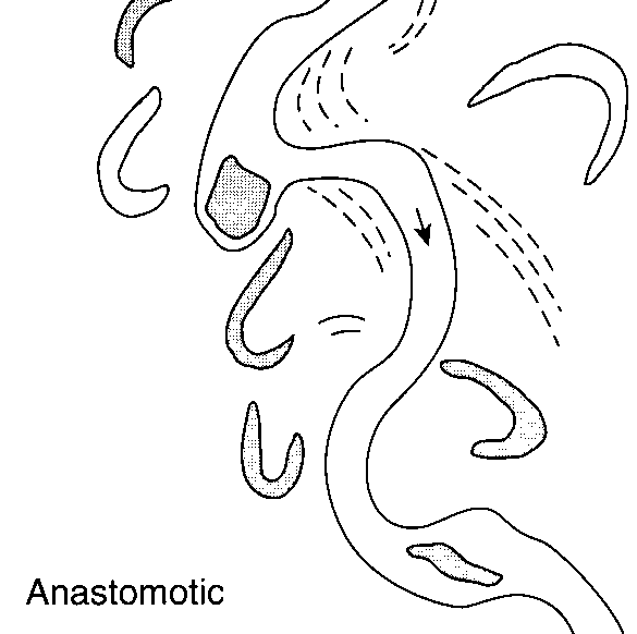
- Abstract
Remote sensing has been used successfully for topographic
analysis and modeling of flood plains. Mature flood plains, those who
have had sufficient time since formation to erode and even out major
surface irregularities tend to have drainage systems that follow an
anastomotic pattern (see illustration). This pattern is characterized
by the serpentine path of rivers and streams and a constantly wandering
path, similar to the rapidly wandering path of a rivulet of water down
a pane of glass. With homes, farm buildings, and agricultural fields
often in proximity of a river and in or near a flood plain, it is
important to reliably analyze the behaviour of an anastomotic drainage
system and predict it’s future path. Through the use of aerial
photographs and/or DOQ (Digital Orthophoto Quad) data, the general
behaviour and near future changes can be modeled and predicted.
What remote sensing data is used in this type of analysis?
 From FRS, pp.301
The first decision facing a researcher, aside from what location to
study, is what type of remote sensing platform to use. To gain an
understanding of the behaviour of a particular drainage system, one
must use data gathered over an extended period of time. Often, this
means years; utilization of the many sources of archived data proves
useful in this situation. Satellite data, such as that from the
Landsat series of satellites, may be useful for flood plain studies,
particularly in larger river systems, and in cases where variations in
the soil, vegetation, and hydrology may serve as indicators of past or
future drainage patterns.
Satellite data is very complete and useful, but "…photography
provides an inexpensive means of mapping the land-water interface and
monitoring changes. (Executive Summary, U.S.G.S. Bulletin 1926, pp.XI)"
DOQ’s (Digital Orthophoto Quads) offer a higher resolution image and
ease of stereoscopic analysis. One of the primary benefits of the use
of DOQ’s is the direct correlation to landmarks and topographic maps.
Through the accurate manipulation of scale, position, and orientation
of an aerial photograph, an aerial photo becomes more useful, and the
position and scale of a feature may be determined to a high degree of
accuracy.- For a small-scale project such as that considered here, aerial
photos in the form of DOQ’s prove to be the most efficient method of
obtaining data. Due to the regular schedule of aerial photography and
the meticulous archiving of past data, there are many years of aerial
photographs available for study for nearly every spot in the United
States. Thus, the analysis of change over time—the clues that allow us
to predict change in the future—is made even easier.
-
-
Determining former drainage paths
- Determining former drainage paths involves
observation of several different sources of data in an aerial photo.
One of the most obvious indicators is tree growth. In arid regions,
tall trees may grow almost exclusively at or near the banks of rivers
or bodies of water. Knowing this, a stand of trees near but not on the
banks of a river, in the appropriate shape, may be interpreted as an
indicator of a recent shift in the river’s path. In climates with
sufficient precipitation to allow for freestanding tree growth, the
absence of old growth trees in an appropriate (oxbow, serpentine)
pattern would indicate that the area had recently been under water.
- Other
vegetation patterns will also tend to outline the former river channels
and banks. The nutrient rich soil left by sedimentary deposition is
quickly settled by rapidly growing plants and grasses. The most
essential element of this feature is that, regardless of the actual
species of plants growing in a former river channel, the type and
density of growth will be different from the norm for the
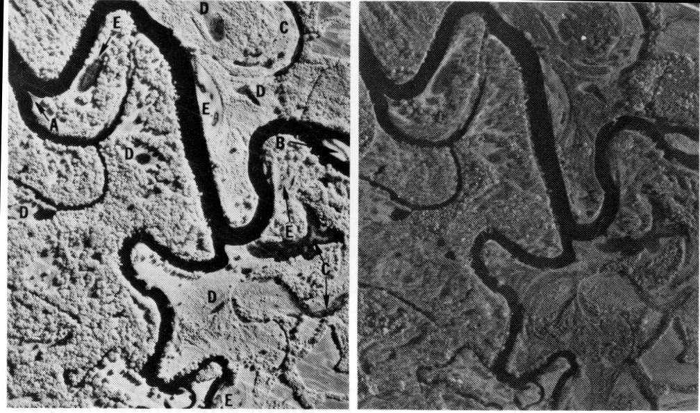 surrounding area.
From FRS, pp.44
In the analysis of vegetation patterns, information from space
based multispectral imaging systems such as the Landsat TM may also
prove useful. The only limiting concern is the resolution of those
photos; airborne multispectral scanning may prove more useful.
Another useful feature to consider when looking for evidence of
former drainage paths is soil. The sediment, sand, and rock common in
a river channel are visibly different from the standard groundcover,
and may be used as a basis for demonstrating the river’s previous
paths. Looking at the image below, a detail from the infrared (left)
photo above, one can see the filled river channel at the upper right
quadrant of the image.
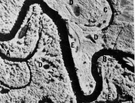 Detail, from FRS pp. 44
A careful eye will also discern some additional river channels
between points E and D. Again, multispectral scanning could provide
some added detail and bring out differences in the soil and vegetation
that would provide more clues to the former drainage patterns.
However, it can be seen through these pictures that simple infrared and
panchromatic photography may provide sufficient data to suggest the
patterns that are being explored.
One site of interest is near Reading Lake in Osage County, KS.
This area (see following illustration) includes a major feed river that
enters the lake from the northwest. Through anecdotal evidence from
local inhabitants, logjams have been building for many years, severely
impeding the flow through the river channel. Ground observations after
major flooding have indicated that the river may be cutting a new
channel to bypass some of the blockage. In this instance, a
winter-scene image using MSS or radar may allow mapping of elevation
contours to determine the location of the line of lowest elevation
across the ithsmus, and thus the future river channel. In this
instance, we see the necessity for predicting such behaviour; local
landowners may need to alter planting or building plans to suit the
behaviour of the river.
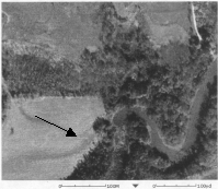
Image courtesy of USGS
via MS Terraserver
Obtaining Aerial Photographs
Many resources exist for the collection of aerial
photographs. Through the internet, it is possible to locate
comprehensive coverage for the entire United States and much of the
rest of the world. A list of useful sites follows, but one of the most
useful for U.S. based research is the U.S. Geological Survey, USGS.
Their Earth Science Information Center (ESIC) archives aerial coverage of the United States and its territories from the 1940’s to present.
Links to sites for obtaining digital RS data
Earth Science Information Center (ESIC)
Data Access and Support Center (DASC)- Kansas Geological Survey (KGS)
- U.S. Geological Survey (USGS)
- IP/GIS Datasets at
Digital Orthophoto Quad (DOQ) search
Other links
GRASS - JSC Digital Image Collection Search (Space images)
GeoTIFF Homepage (New digital distribution techniques)
Conclusion
Analysis of digital orthophotos and other readily available
forms of RS data gives the researcher sufficient data reserves to
monitor the behaviour of anastomotic drainage systems and make some
predictions about future behaviour. Additional data, in the form of
multispectral imaging and radar imaging, may increase the accuracy of
these predictions.
References
Aber, James. Instructions for Creating Earth Science Student Webpages. http://academic.emporia.edu/aberjame/web_page.htm
Avery, Thomas E. Fundamentals of Remote Sensing and Airphoto Interpretation, 5th Ed., New Jersey, 1992. Abbrev. FRS.
U.S. Department of the Interior, USGS National Mapping Division.
National Mapping Program Technical Instructions: Standards for Digital
Orthophotos. 12/96, Adobe PDF document.
U.S. Geological Survey. How to Obtain Aerial Photographs. http://mapping.usgs.gov/esic/aphowto.html.
Watson, Ken et. al. Airborne Remote Sensing for Geology and the Environment—Present and Future. U.S. Geological Survey Bulletin 1926.

Back to ES771 Syllabus | Emporia State University Home