| Matthew N. Selvey Family Blue Springs, Missouri |
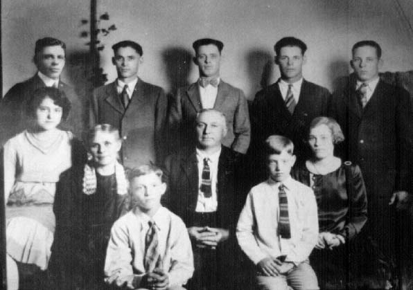
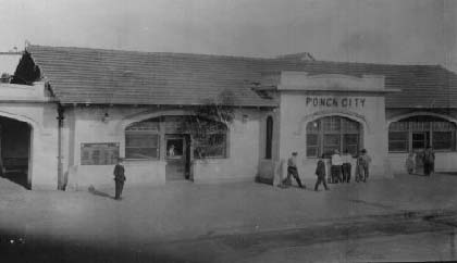
MELCHI ESLEY SELVEY & LILLIE JANE MOORE Missouri - Oklahoma 1890�s Lillie Jane Moore was the eighth child born to Sirmira Angeline and James Nicholas Moore. She was born September 12, 1875 (died January 10, 1955) in Lone Jack, MO. She married Melchi Esley Selvey (born September 21, 1870; died May 21, 1931), in Blue Springs, MO. She was a very small woman, probably less than five feet tall, and before her first child was born had polio or paralysis and was unable to walk well. About 1891, Lillie Jane and Melchi Esley moved to Oklahoma, near Ponca City. Photo From Virginia Selvey Davidson� Back row: Buford, Eugene Virgus, James Matthew Lloyd, Dillard, John Wesley; Ollie Jane, Lillie, Melchi Esley, Grace Elizabeth; Paul B.; Silas |
 |
 |
 |
| More on Matthew and Melchi Selvey can be found on the Selvey Charts 4th Generation... Line 6 |
| Connie and I need more on the Matthew Selvey Families [email protected] |
| Matthew N. Selvey Funeral services for Matthew Selvey, father of Mrs. S. A. Beal of Independence were conducted at 11 o'clock Sunday morning at the Baptist Church in Blue Springs, Missouri. Mr. Selvey had resided for many years in the area, services were in charge of Rev. F. M. Stillions of Blue Springs burial Blue Springs cemetery. In the Sni-Bar Voice newspaper dated Sept. 16, 1921 the obituary for Matthew Selvey read as he being born in Tennessee Feb. 7, 1839. In infancy moved with his parents to Virginia and thence to Missouri at the age of 16. Mr. Selvey was converted in 1914 and united with the Baptist Church of this city. He has been confined to his room for the past six years, during which time he found great consolation in the savior and in his messages. Through all these years of sickness he was faithfully and loving cared for by his daughter Mrs. Lucy Clark. On September 9, 1921 at 10:25 p.m. he departed his deceased, weary body to enter into rest. He leaves two sons, M.A. Selvey of Bliss, Ok., M.E. Selvey of Ponica City, Ok., and six daughters Mrs. John Snodgress of Lone Jack, Missouri, Mrs. S. A. Clark of independence, Missouri, Mrs. G. W. Alley of Lee�s Summit, Missouri, Mrs. Burton Mc Daniels Clark of Blue Springs, Missouri, Mrs. Molly Roydston of Fairmont, Mrs. Alley Patterson of California. Besides three sons and daughter there are 49 grandchildren and 41 great-grandchildren to mourn the temporal loss of the loved one. Funeral services were conducted Sunday, September 11th at the Baptist Church by Rev. Franklin Stillions the pastor. Matt Selvey was 82 years, 7 month, and 2 days old. Children listed in Matt�s will were, Martha S. Snodgrass, Lucy A. Brown, Manassas A. Selvey, Mary L. Boydston, Sarah E. Alley, Boda A. Beal, Melchi E. Selvey, Alice E. Selleck. Personal property consisted of household goods, 2 horse harness, and 3 head of hogs and a chattle mortgage and note for $100.00. Total value of property left would not exceed $250.00. Note was presented to the court by his wife. At the time of Matthew Selvey�s death his real estate consisted of lot 2 and 3 in block 4 of the Webb addition of Blue Springs, value $1000.00. All of lot #5 in Block 2, in the Mocks addition in Blue Springs. Cash in the bank $1,517.00 and notes and loans due him for a total of $4238.21. Burial expenses for Matthew Selvey consisted of the following, casket costing $185.00; suit $25.00, ambulance $10.00, sexton fees $8.00, hoes .50, total cost for the funeral $228.50. Matt Selvey had a large family, two sons Essie and Manassas moved to Oklahoma the remainder stayed in Missouri. To See Lands and Home Locations in Jackson County of our Selvey Ancestors. By David Clow June 2000� Take 470 to Lees Summit exit 7B to 350, go 21/2 miles turn right or north at the stop light on V Hwy also called Noland Road. Go 41/2 miles on Noland Road to 40 hwy, turn right or east on 40 hwy and go 11/2 miles east to Lees Summit Road. Turn left or north at Stephenson�s Restaurant and go 1 mile to 39 Street, turn left or west on 39th Street and go 2 blocks to the Church of Christ. The church has 2 buildings one is concrete and the other is brick. My ancestor Reuben Harris is buried under the front steps of this brick building church. This was a cemetery and when they moved the graves to build the church Reuben Harris grave was unmarked. A marker was placed in the Blue Springs Cemetery near the Selvey sites. Later it was determined that Reuben Harris�s bone were still in the area of and under the front steps of the church. Now go back to Lees Summit Road go south to I 70 and then east to exit 18 on Woods Chapel Road, now right or south on Woods Chapel Road, about 1 mile to the Old Mill Park. This was the original old town of Blue Springs and at the southwest corner of this park was the old spring first owned by William Harris a son of Reuben Harris. From this park go south on Woods Chapel Road to Walnut Street turn left on Walnut Street about � mile to the Blue Springs Cemetery, which is across the street from the United Methodist Church. Enter the cemetery through the old rock walls or gate and immediately on entering the cemetery you are in the northwest corner of the cemetery and this is where John and Elizabeth Selvey are buried and 3 feet west of John Selvey grave is the grave of Japtha Crawford. East and south of John Selvey is Reuben Harris all these are my grandparents, great, great, greats or so. When you leave the cemetery go back out the same way you came in onto Walnut Street and then go south on Walnut to Woods Chapel Road. Turn left on Woods�s Chapel go � mile south to 40 hwy. Turn right or west on 40 hwy. At this corner you are looking at the eastern part of the 700 acres that James D. Hall my great great grandfather owned, his land took in of most of the Lake Tappawingo addition. Now your going west on 40 hwy, go past Bowlin Road and you come to the old Stanley Cemetery on the south it sets between the west and the east bound lanes. Halls and the Stanleys are buried here more of our great greats. Cut through the service station drive get on the east bound side of 40 hwy and go � mile to Woods Chapel Road turn right in Wood Chapel now going south now across the lakes, now turn left or east on Leggitt Road. Cross the Jacomo dam, when you are crossing the dam look north or left, the water you see now is below Jacomo and is the Blue Springs Lake water and out in the water is a concrete structure and this is about the area that Garnett Selvey owned 12 acres on the Little Blue River (1840). At the east end of the Jacomo dam and to the right is shelter house #1 is the site of a school which is where Robert Selvey grandma Ethel Joyces, Leland and Roy Selvey�s father attended 1 or 2 grades of school. Now continue east on Leggitt Road � mile and when the road turn to the south you can see a old hedge row running east and what use to be a road that went on east � of a mile this is the south west corner of land owned by John B. Selvey in the middle 1800s. This is where John B. Selvey lived, the house at 3200 Leggitt Road would be the extreme western edge of John Selvey�s land. To see where the Selvey house stood continue on south on Leggit Road a couple of blocks it turns back east to the first street S.W. 22nd Street. Turn left or north go 3 blocks to a dead end 3150 SW 22nd Street, it�s a private drive and where the house sets is the same location where John Selveys house set. The Selvey farm contained 40 acres. Now go back out to Leggitt Road and continue east � mile to 7 hwy. Turn right or south on 7 hwy look for South Gate Dr. on the left while going south on 7 hwy. This is land that Louis Selvey owned he�s a brother to John Selvey. Continue South on 7 hwy to Wyatt Road, if Wyatt Road went west you would be at the little house that Charles Selvey and John B. Selvey built, and where John B. Selvey died. If the road went through to Jasper Bell Road you would find the second house that Charles Selvey built and later the home of Ray Selvey. To get to Ray�s old home place you�ll have to go on south on 7 Hwy to Cowherd Road and then west to Jasper Bell Road. Now your are back on 7 Hwy and still going south to Colburn Road, turn east or left and go 1 � miles to gate # 1 to Lake Lotawana. Continue east � mile and on the south or right before you get to the little river is the land of Matt Selvey a brother to John B, Selvey. Now continue east on Colburn it dead ends at the Buckner Tarnsey Road turn north or left on Buckner Tarnsey go 1 � mile to the Harris Pots Road turn left or back west follow this winding road 1 mile to a hard 90 degree to the right or north. Now go � mile to the corner of Old Maror Road and Enoch Mill Road on the southeast corner of this intersection is the land my great great grandfather Japtha Crawford family lived, he was shot here during the Civil War. Now go north just 1 block to Major Road turn left, go to Cook Road and turn left to Wyatt Road again and on the northwest corner here is the land of Lewis Selvey another brother to John B, Selvey. Lewis was a horse trader and died in Kansas City while trading horses. Going to bed he blew out a gas lamp in his hotel room thinking it was a coal oil lamp and the gas in the room killed him. To get back to 7 hwy goes west on Wyatt Road to 7 hwy and then north to I70� Hope you enjoyed the trip� |