Ottawa, Ontario
Latitude 45 19 N (45.3), Longitude 75 40 W (- 75.7)
Sun and weather statistics
Click here for NASA SSE data (solar radiation and surface weather) for Ottawa
Parameter definitions for the NASA SSE data presented at above link
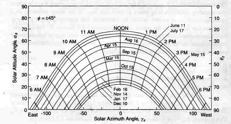
Solar position chart for latitude 45º :
Solar azimuth angle: the horizontal angle between south and the position of the sun.
Solar altitude angle: the vertical angle between the horizon and the position of the sun.
Zenith angle: (theta sub z) the angle between vertical and the position of the sun.
The University of Oregon Solar Radiation Monitoring Laboratory offers
an on-line program that creates sun position charts for any point
on the surface of the earth, in either solar time or local standard
time. The program may be used at http://solardat.uoregon.edu/SunChartProgram.html.
It creates Adobe PDF files that may be printed to produce full page
images that are convenient for plotting the shade produced by objects
near a solar collector. I have used the this program to produce
files for Ottawa which are available here: June to December - EST (pdf), and December to June - EST (pdf).
I chose to produce these charts to show the azimuth of the sun at local
standard time (Universal Time - 5 hours = Eastern Standard Time). As a
result, the line for the position of the sun at noon is S shaped, as
compared to the straight line in the chart shown above.
David Delaney home

