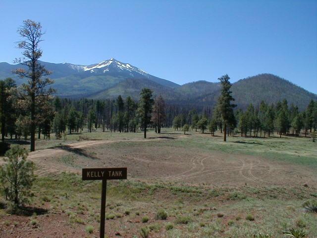
| BABBITT RANCH/COCONINO RIM* (REAL COWBOY COUNTRY) Where are we on the AZT? This segment starts in the San Francisco Peaks near the Arizona Snow Bowl, travels across miles of cattle country and ends 73 miles later at the South Kaibab Trailhead. Route: The AZT Trail, or any kind of human trail, for the first few miles from the Snow Bowl is non existent. It�s a good test of one�s trail sense and use of the compass. The goal is get to the Kelly Tank area where the signed AZT starts again. Arizona Snow Bowl to Cedar Tank Ranch area (20 miles): At the most northern parking lot at the Snow Bowl, walk northwest across a beautiful meadow for a few hundred yards until reaching Kachina Wilderness markers. Continue north just outside (west) of the Wilderness area for about 3 miles. If you get lost in the forest, keep heading north until reaching Hart Prairie Road FR #418. There are a few summer homes along this well maintained road. Continue north of FR #418 for another 2-3 miles, hopefully on some ranch type roads, passing west of White Horse Hills until reaching FR #514, another well maintained road. Alas, after a short walk east on FR #514 to Kelly Tank, the signed AZT reappears on the north side of the road and unfortunately on the other side of the fence.. The pleasant but currently burned tree-filled trail parallels FR #514 heading north for about 2 � miles and then continues north where #514 veers east. The trail is hard to find here but just walk north. Within a half mile, the AZT crosses another forest road (#523) and continues north on a lesser quality but signed forest road #416. Forest Rd #416 will take you just west of Missouri Bill Hill to the northern boundary of the Coconino National Forest where the trail turns west and in just under 3 miles passes to within eyesight of the Cedar Tank Ranch to the south. I think the song Wide Open Spaces got its name from this area. Cedar Tank Ranch to the Grand Canyon (52miles): The AZT is now in the Babbit Ranch area and on the Kaibab National Forest map.. The Kaibab National Forest is so big they sell two different maps to adequately cover it all. The route through here is well AZT signed, often along rancher roads from Cedar Tank Ranch to the Grandview Firetower that is located at the Grand Canyon National Park boundary. At Cedar Tank Ranch, the AZT turns north on the road(9008A) to Tub Ranch. On the road by Cedar Tank ranch, there's a wecoming AZT sign there. Five miles north, at Tub Ranch the trail/road passes thru a gate and continues up a small mesa behind (north of) Tub Ranch The road continues northwest for about 5 more miles and passes under power lines. It then heads generally north for nearly 7 miles to Upper Lockwood Tank. It then winds northeast a long mile thru a small valley to Lockwood Tank and FR # 301. At Lockwood Tank there's a large, generally dry, stock tank and the remnants of a cowboy shack and corral on the small mesa above the trail and stock tank. Turn left, northwest, on FR #301 and walk 2 miles where the road/trail exits Babbit Ranch at a gate and enters the Kaibab National Forest. Leave the road and turn left.because, after a whole lot of road miles, the AZT finally leaves the road for a cairn marked trail. It pleasantly makes its way northwest to the historic Moqui Stage Stop five miles ahead. The trail turns north � mile before reaching the Moqui Stage Stop location. But, be sure to make the short trek over to the long ago stage stop and take a break. Once back on the AZT you will be entering a much more tree lined and rolling stretch. A welcome change from the previous road miles. Plus the trail continues to be well AZT signed as it makes its way to Russell Tank. There�s a cattle tank at Russell Tank and a nice area to camp. Heck it even has block wall bathrooms too. On both edges of the Russel Tank area the trail passes through small gates. In less than 2 miles, the trail crosses FR #310 and there's only 10 miles to Grandview Firetower. For about a mile the trail is a bit overgrown and difficult to follow as it makes its way through a small canyon. It's a beautiful area though and provides some nice long distant views to the NE. Good trail returns and as the trail approaches the Grandview Firetower area, there are several interpretive signs about replanting trees, mistletoe disease etc. The signs are the most interesting thing to read since Flagstaff. The Grandview Firetower area is another good place to camp although there�s no water. And no reservations are needed as it�s just outside the GC National Park. The AZT route from here to the Grand Canyon National Park (actually to the North Rim) is all unofficial i.e. there ain�t no signs or designated routes. West across the road from the Grandview Firetower, follow the Tusayan Bike Trail by the parking lot for about 16 miles to just north of the town of Tusayan. There's lots of decent camping spots in this stretch. The bike trail actually goes west under highway 180/64. But instead of going under it, follow the path north. Soon you will cross into the Grand Canyon National Park thru a gate. If your conscience is bothering you the fee station on the highway is west less than a half mile. As you hike north on old 2 tracks, stay left when the road Y's. AFter 2 1/2 miles, the path swings to the highway but walk on it for only a few hundred yards before veering off on another 2 track. This too will parallel the paved highway for another 1+ mile before it turns east for another nearly 2 miles where it comes to highway #64 near the point where the road entering the S. Kaibab Trailhead/Yaki Point turnoff is. The tram comes to the Trailhead area and I strongly recommend taking it to the village for a shower at the laundry. Also, remember, you need overnight backpacking permits from the Backcountry Information Center (928-638-7875) to camp anywhere in the Canyon. A fee of $10 per permit and $5 per person per night was charged in 2001. They don�t take phone in reservations either. But they do take walk-ins if there are camp sites available. Worthwhile Detours from the AZT: The relics of the Moqui Stage Station are worth the short detour if only to say you were there. A climb to the top of the Grandview Firetower could be a life ending thrill. If you have the nerve, a neighborly stop at Tub Ranch could be memorable. The ranchers along this stretch waved as they drove by ( but a hiker tells me he made this stop and was greeted by 5 snarling dogs). Tusayan isn't notable but if you need a room or meal, it works. But ya gotta stop and see some of the differnt Grand Canyon Rim views in the Park. Places to Camp � Camping is only permitted in designated campsites in the Grand Canyon National Park. Thus the Grandview Firetower area is a definite campsite, if you don't have a permit. ANd there's lots of decent camp spots west of the Firetower to Tusayan. In adition, near Russell Tank is a decent spot too. The center section of this segment, from Cedar Ranch to Moqui Stage Stop, is kinda like camping in Kansas. There�s lots of flat ground, not a lot of trees, but jaw-dropping, fantastic, very photogenic sunrises and sunsets. And finally on both ends of this segment, there are some peaceful meadows, woods and quiet places to set up for a night. Take your pick. Length � >73 miles Power Rating � Easy physically, signed well, and it would be difficult to get lost on the trail/road. It�s a long stretch but per day mileage should be very high. Water* � There are no streams along this route. But there are a number of cattle tanks, a couple of ranches, and a few, usually vacated, summer homes north of the Peaks. Be sure to have a full water supply for the 26 mile stretch from Tub Ranch to a few miles south of Russell Tank. I don�t know what kind of reception one might get at Tub Ranch though I have found cattle ranchers quite friendly. Watch out for their dogs tho. And, take off the vegetarian patches before knocking at the gate. And one hiker reports that there is water in a holding tank behind the cabin at the Grandview Firetower. Finally, Tusayan of course has water and there's water at the South Kaibab Trailhead (and bathrooms). Bikeable? Real bike friendly. From Hart Prairie Road FR #418, this is one long stretch that could be ridden but take the signed bike detours between Russell Tank and the Grandview Firetower. Permits � See above. Camping is only permitted in designated campsites in the Grand Canyon National Park. And a site is difficult to get many nights. And, of course, permits are needed below the Canyon�s rim. Maps** � The Four Peaks Ranger Station sent me a copy of a topo map that someone had personally highlighted the AZT to Coconino National Forest�s northern boundary. Be sure to request one from them. That and the Kaibab National Forest maps will get you to the Grand Canyon. Advice � The Grand Canyon Crunch ice cream at the Bright Angel Lodge snack bar is a just reward at the end of this lengthy segment. Cautions � Expect lots of people in the Grand Canyon Village. It gets several million visitors a year. Everyone deserves to marvel at this natural spectacle so be patient with the visitors. And don�t worry, only a fraction of a percent are going to hike very far into the Canyon. And be carefull in the Fall if you are west of the Grandview Firetower to Tusayan. This is a hunting area. The good news is the hunters have some elaborate camp sites and are usually a friendly bunch ready to share the-more-than-enuff goodies they bring. Life on The AZT � Bring your checkbook. There was a large �For Sale� sign near Kelly Tank. It was on a beautiful piece of ground that looked south towards the majestic San Francisco Peaks. * Remember just about all water sources are seasonal in Arizona. Check with as many sources as possible before entering an area, including the local National Forest Service. **(In addition to On the Arizona Trail guide book) HOME EMAIL ME NEXT CHAPTER |
 |
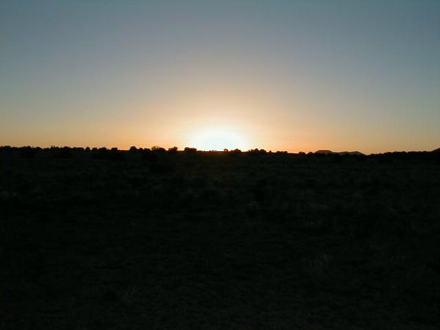 |
| L) Looking back at the San Francisco Peaks Below) The best sunrises on the AZT |