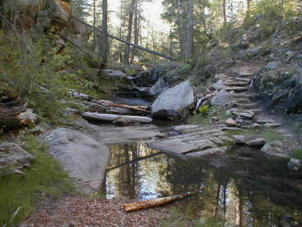
| THE MOGOLLON RIM TO MORMON LAKE* Where are we on the AZT? This section starts at the Pine Trailhead and travels east on the Highline Trail to Washington Park. Then, after ascending the Mogollon Rim the AZT continues north until it reaches the Blue Ridge Campground. From the Blue Ridge Campground the trail leisurely travels northwest to the Mormon Lake area. And then wrapping around the western side of Mormon Lake this stretch ends at Highway #3 at turnoff to Ashurst Lake, 82E. A distance of 82 miles. Route: Pine Trailhead to Blue Ridge Campground (29 miles): The Pine trailhead is on the southern outskirts of Pine, AZ. along Highway #87. Proceed east on the Highline Trail #31 for nearly 16 miles. It�s distinct, easy to follow, never level or straight but not dramatically changing either. The trail stays below and south of the Mogollon Rim as it passes near Camp Geronimo and by Geronimo Springs until it reaches Washington Park, which is 16 miles from the Pine TH. At Washington Park there�s a trailhead/parking area where the trail proceeds north, finally ascending 1000� to the Rim and a well-maintained and popular forest road. There�s also a Battle of Big Dry Wash historical marker at this spot. Continue north on the gravel road for a � mile to the General Springs Cabin and onto the Fred Haught Trail. This begins a simply beautiful trek (see below). You�ll love it. The Fred Haught Trail continues for 2-3 miles. A carsonite marker, kinda confusingly, points left (north) as the AZT veers from the Haught Trail. 5-6 miles further the trail dips down and crosses East Clear Creek and shortly thereafter it passes right through the middle of Rock Crossing Campground. Another 3 miles of easy hiking and the AZT comes to the Blue Ridge Campground. Blue Ridge Campground to Mormon Lake (44 miles): The AZT continues north from the Blue Ridge Campground for a mile where it again crosses Highway #87. Passing through a metal gate the trail continues on faint paths, crossing FR #211 after another mile and, continuing northwesterly for another 2-3 miles it crosses FR #82. As you approach FR #82, the AZT parallels the forest road for a few hundred yards north before it (the AZT) crosses FR #82. (So if you get to FR #82 and don�t see the trail heading west, you are probably too far south.). The AZT continues west and north on jeep roads, trails and through forest land. It�s signed through here but you have to keep an eye out for AZT markers. In some areas the signs are tacked 8-9 feet up a tree. The AZT passes by Turkey Mtn and Gonzalez Tank, as it proceeds north and west passing just to the north of Pine Mtn. where it connects with FR #135. After a mile, FR #135 junctions with FR #294 in the Bargaman Park area (there isn't a city like park there tho). This spot is about 22 miles from the Blue Ridge Campground. The AZT proceeds south at the junction alongside FR #294 and winds itself south, west and then north where, 8 miles later, it returns to and crosses FR #135. {Or if you are biking, I suggest continuing west on FR #135 from its junction with FR #294. West of the junction, FR #135 is a well-maintained dirt road that passes by the Mahan Ranch area. Five miles from the junction (about a mile east of Highway #3) is the point, described three sentences ago, where the AZT crosses #FR 135.} After crossing FR #135, the AZT proceeds north on a jeep path. There are AZT signs occasionally as the trail continues north and west and approaches Allen Lake and Highway #3. If you miss the signs, walk north alongside Highway #3 until reaching FR #91 where 1/2 mile west on #91 there's an AZT marker. At the point where the AZT crosses FR #91, the Mormon Lake Lodge and Store is about 6 miles north and slightly west. AZT signage soon becomes non existent but that's OK as this is a lovely area to use some of the Arizona Trail sense that you have developed since starting your adventure. And, if as you wander this area, you come to FR #219 follow it north to the Lodge/Store area. The AZT is planned to pass about 2 miles south of the Lodge/Store and semicircle around the west side of the lake to Double Springs and Dairy Springs Campgrounds. The Double Springs area is about 22 miles from Bargaman Park. Mormon Lake to Highway #3 (9 miles): The planned trail leaves the Double Springs Camp and passes Dairy Springs in another mile. It stays west of the paved lake road and continues north where it comes to and follows an old railroad grade for about 2.5 miles. At that point it leaves the RR grade and turns east for a mile where it comes to Highway #3 at the Pine Grove and Ashurst Lake turnoff, 82E. Suggestion: Until the AZT is completed, I suggest walking northwesterly from the Mormon Lake Lodge site directly across the dry lake. At the northwest edge of the lake, exit and walk west to the paved road, then follow the paved road for about 1 1/2 miles to FR #132. Take #132 west for 1/4 mile to an unsigned (hopefully it's signed now) trail. That's the AZT and it's a very pleasant, distinct path for about 5 miles to Highway #3. Worthwhile Detours from the AZT: 1) The town of Pine, of course. It�s a cozy little place. And Payson, which 30 years ago was like Pine, is 20 miles south of Pine if you can get a ride. Payson has chain restaurants, motels, retail stores. You know, the kinds of places with stuff you want to get away from but just can�t pass up when you�re close to them, like a Dairy Queen Blizzard. 2) The Blue Ridge Ranger station is less than a mile east of where the AZT crosses Highway #87, near the Blue Ridge campground. 3) And finally, a must for those wishing to break a steady diet of Top Ramen, the Mormon Lake Lodge area (www.mormonlakelodge.co) � a restaurant, grocery, campground, laundry, shower, post office, friendly folk, etc. Places to Camp � 1) Pine Trailhead; 2) several spots along the Highline Trail; 3) near General Springs Cabin is a nice spot; 4) Rock Crossing and Blue Ridge Campgrounds are both established small fee sites; 5) Double Springs and Dairy Springs Campgrounds at Mormon Lake; and best of all 6) many spots alongside the trail. Length � I estimate 82 miles. Power Rating � Overall this section is a definite moderate. The short ascent to the top of the Mogollon Rim from Washington Park is the only real huffer. The trek along the Highline Trail is moderate, as is the area between the top of the Rim and Blue Ridge Campground. From Blue Ridge to Mormon Lake physically it�s easy. But finding the trail is a little difficult, tho, even if one does get lost, it doesn�t take much to wander onward to Mormon Lake. Water* � Springtime 2001, the creeks were trickling on the Highline Trail. And there were several small creeks from the Rim to the Blue Ridge Campground, including East Clear Creek, which flows into the Blue Ridge Reservoir. The streams disappear between Blue Ridge and Mormon Lake though there are some cattle tanks along the way. Blue Ridge and Rock Crossing campgrounds, when open,have water. There's the Blue Ridge Ranger station too. And, of course, the Mormon Lake community has water. Bikeable? Definitely! It�s a bikerider's passage from Blue Ridge Campground to Mormon Lake. And for the better riders, the Highline Trail is a challenge. Getting up the Mogollon Rim is a carry-your-bike section. And, from the top of Rim to Blue Ridge Campground it's a doable ride, tho there are nearby forest roads to traverse this area on a bike too. Permits � None needed. Maps** � The Blue Ridge Ranger Station (Blue Ridge Ranger Station, HC 31, Box 300, Happy Jack AZ 86024, 928-477-2255) sent me a copy, with the AZT path highlighted, of a decent map of the area from General Springs Cabin at the Rim to just south of Mormon Lake. Very worthwhile to have. Also, the Coconino National Forest Map, 928-527-3600 is available for a fee. Advice � Stop by the Blue Ridge Ranger station for advice, water and bathroom before continuing north. It�s about a mile northeast of the Blue Ridge Camp on Highway #87. And also more importantly, I don�t miss a chance for some waitress served restaurant food and suggest heading directly to the Mormon Lake Lodge restaurant from FR #91. Cautions � Even in late May the night-time temperature drops considerably once on the Rim. It got down to 39 degrees by General Springs cabin on the night of May 22, 2001. Life on The AZT � My AZT hike along from General Springs Cabin to the Blue Ridge Campground was what I call a �Bo Derek� experience. A definite �10�. The trail offered cool shaded trees, picturesque streams, some magnificent long distance views, coyotes, elk and my first black bear sighting. What a thrilling piece of the Arizona Trail! * Remember just about all water sources are seasonal in Arizona. Check with as many sources as possible before entering an area, including the local National Forest Service. **(In addition to On the Arizona Trail guide book) HOME EMAIL ME NEXT CHAPTER |
 |