| THE LEGENDARY SUPERSTITIONS* Where are we on the AZT? This section starts at the AZT Trailhead, near Picket Post Mountain, that is four miles west of Superior, Arizona. The AZT proceeds north over the Superstition Mountains and ends up nearly 42 miles away at the Lake Roosevelt bridge and dam. Put on your hiking glasses because you are going to see firsthand a picture of Arizona. Route: The trailhead is � mile south of Highway #60. [If driving, turn south off of Hgwy #60 between milepost #221 and #222 and soon you�ll see an old windmill] The trail proceeds north from the trailhead on a good trail before shortly coming to a passage under Highway #60. There�s some rock cairns along the wash south of and leading to the highway, but there�s nothing on the highway to denote that the AZT crosses underneath it at this point. North of the highway the trail goes up the west side of the wash. The trail is faint in places but a few rock cairns point the way. The terrain is gentle and after a few miles crosses Hewitt Station Rd. and a railroad track. There are some AZT posts that help. About 3-4 miles from the trailhead, in beautiful Whitford Canyon, the trail will pass alongside a trickling stream through a very weedy section. Keep your eyes on the trail beneath the weeds and also for any little creatures lurking within them. Soon the trail reaches Forest Road #650. The AZT crosses the road and meanders in and out of some gorgeous desert terrain for a few miles before returning to FR #650. Just south of the road is an AZT sign that leads into the Reavis Canyon. The trail is easy as it follows a streambed and crosses a flat, rock floor area before it ascends a pass over Montana Mountain. That climb is a huffer. At the end of the climb, the trail returns again to FR #650 and heads west on the road for less than a mile and then north for less than a mile when it comes to a T with another road. Turn left at the T through a gate and follow that road as it descends to FR #172A and Rogers Trough. You�ve just put in a solid 15 miles. Rogers Trough has a parking area, seasonal stream (the spring is a short distance to the east) and good places to pitch camp. While Rogers Trough is an OK place to camp, just 6 miles further on the AZT is the popular Reavis Ranch area, a true oasis. Old Elisha Reavis was thought to be a bit crazy when he established his farm in the middle of the Superstitions in the late 1800�s. Crazy like an AZT hiker me thinks. Anyway, from Rogers Trough, the AZT follows the creek northwest for 1 � mile on the Reavis Ranch Trail #109. At that point, stay on the Reavis Ranch Trail for 4.5 more miles as it turns right (north) at the junction with the Rogers Creek Trail. Slowly the scenery changes as the trees get taller, leafier and more dense. There are tall pines, sycamore and even Fall apple producing trees that old man Reavis may have planted. There�s lots of flat, soft, grassy ground near the stream that passes by the remnants of the farmhouse. Stop here. Lie down, close your eyes and enjoy! Finding the trail out of the Reavis Ranch area is a little confusing but from there on it�s generally easy for the 12 mile hike to Cottonwood Creek. There�s a signed turn off about a half mile north of the Reavis Ranch remnants. Turn right 90 degrees onto Reavis Gap Trail # 117 (the AZT directional sign is on the wrong side of the sign post). Be careful here and don�t go through the fence opening but turn right and cross the grass meadow about 100 yards. You�ll immediately begin an ascent up a rocky path. The trail then ascends and descends for many miles. There are spectacular views in several directions, most noteworthy the Four Peaks mountain range that dares the AZT hiker to step foot onto her domain. After 3.3 miles on the Reavis Gap Trail #117, the AZT turns north on the Two Bar Ridge Trail #119. The Two Bar Ridge trail is pretty faint in several places. Look closely for rock cairns. And about a mile from the #117/#119 junction is Walnut Spring which had a decent pool in May 03. But I doubt it will last very much later in the year. There are some Indian village ruins in the area too. About a mile north of Walnut Spring the trail descends into another dry creekbed and then ascends about 900'. Pay close attention as you climb out of the creekbed because about 200' up, the trail passes some very old, distinct rock walls of some long ago Indian community. Pretty darn neat. At the top of the ascent,.Apache Lake comes into view in the distance to the west. The trail offers continued vistas as it follows along the mountain�s ridgelines for several miles.. Best of all, the trail is easy to follow. After 4 miles on the Two Bar Ridge Trail, the trail passes the Tule Trail #122 which heads east. Continue on the Two Bar Ridge Trail as it switchbacks up most of Pinyon Mountain before it turns east and passes some old signs noting you are leaving the Superstition Wilderness Area. Shortly,the trail arrives at FR#83 and follows the rough road for about 1 1/2 miles where it comes to a junction with trail #120 that leads into Cottonwood Creek. The first mile heading south along Cottonwood Creek is cairned often as the trail crosses the creek numerous times. Then suddenly and happily, the scenery becomes lush and tree lined as it comes to Cottonwood Spring. It offered a decent trickle of water in May 03. The tall trees only last a few hundred yards. But less than a mile further, a similar area awaits, tho in May 03 it offered no water. But it did have enuff space for a nice overnight camp site. From that spot the trail emerges into the saguaro lined desert trail with tall cliffs overhead. Then the trail joins FR# 341 and follows it several miles. Views of Roosevelt Lake make for some great pictures. Soon the trail turns onto Trail #121, soon overlooks a mobile home park and a Z shaped fence gate that leads to a 1906-1915 cemetery. It's worthwhile to walk the 200 yards and take a look at it. (This is also a nice exit to the Marina store, Ranger Station and lake which are directly across the highway from the mobile home park). The final 1 1/2 miles to the Lake Roosevelt bridge are a tuffy. Up and down several long grades and in and out of several drainages. The trail exits to Highway #88 and continues on the highway over the dam bridge where it joins the Vineyard Trail. Worthwhile Detours from the AZT: 1) On the Rogers Creek Trail #110, about 1 mile west of its junction with the Reavis Ranch Trail #109, there are some Indian ruins. As noted above there are a couple of other ruins along the AZT route too, 2) the early 1900 cemetery near lake Roosevelt is kinda different for the AZT and 3) the store at the Lake Roosevelt marina (a mile southeast of the dam) offers some food and drink that a weary hiker might want. They even have a light menu of cooked meals too. They are only open Fri-Sunday until May tho, and 3) the overlook at the dam is worth a stop too. Places to Camp � 1) Don't camp at Picket Post TH, it's too noisy. 2) Whitford Canyon and Reavis Canyon offer two great springtime campsites that usually have water. 3) The best camp site, as mentioned above, is Reavis Ranch and many Phoenix area hikers backpack there for a night or two, 4) Just before reaching Pinyon Mt there is a nice spot in the trees that some hikers have used. 5) And at Roosevelt Lake, behind the Ranger Station, along the shorline it is especially nice except the ground isn�t a sandy beach. But, the water provides a wonderful bath after a day�s hike though. Length � A long 42 miles. Power Rating � A tough segment. The elevation challenge was a 9 on the 10 scale and the trail condition was rocky in several short sections. A hiker with a hurt ankle could be on Two Bar Ridge many days before anyone else happened along. Water* � In the late winter and springtime of 2001 and 2003, there were several small streams running between Picket Post TH and Reavis Ranch. But between Reavis Ranch and Lake Roosevelt, water is sparse. Carry plenty of water but look for the few possibilities like Pine Creek and Walnut Spring which is 4 miles north of Reavis Gap. Also, note, I found no water in the cattle troughs at the southern end of Cottonwood Creek. But there was a dirt stock tank on FR #83 west of trail #120/Cottonwood Creek. And, there was water at Cottonwood Spring in May 2003.. Bikeable? Not unless your bike has wings. Anyway, it's another big Wilderness Area. I suggest taking the very scenic Apache Trail (SR #88) from Apache Junction, AZ. to the Lake Roosevelt Dam. The paved highway turns to dirt somewhere east of Tortilla Flats (restaurant!). It won't be any easy haul but there's lots of places to camp and great views. Permits � None needed. But, there�s a small fee to camp at Lake Roosevelt. Maps** � 1) Superstition Wilderness Outdoor Recreation Map by Beartooth Publishing, Big Sky, MT (very good); 2) Tonto National Forest Map; 3) the Tonto Basin Ranger District Roosevelt, AZ, 85545 also has copies of topo maps on which they highlight the AZT for some of this section. Advice - Take a swim in Lake Roosevelt. It�s the best bath you�ll get in 50 miles. Cautions � There�s lots of old west stories about many people who mysteriously died or disappeared in the aptly named Superstition Mountains. I suggest you not read any of them until after you have hiked through this segment. Life on The AZT � As I trekked high upon the Two Bar Ridge trail in 2001, I thought there wasn�t another person for miles. Suddenly an Air Force Jet came whooshing by so close I could see the pilot. Too cool. * Remember just about all water sources are seasonal in Arizona. Check with as many sources as possible before entering an area, including the local National Forest Service. **(In addition to On the Arizona Trail guide book) HOME EMAIL ME NEXT CHAPTER |
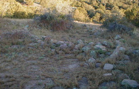 |
| Ruins near Walnut Springs |