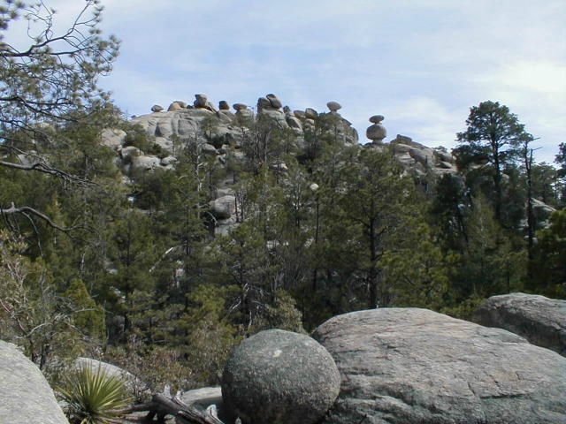
| The Santa Catalina Mountains � Paradise in the Desert* Where are we on the AZT? Northeast of Tucson, Az, around and over the Santa Catalina Mountains. More precisely, this route is from Reddington Road to Molino Base Camp to Romero Pass around Mt. Lemmon to NE of the town of Oracle. About 57 miles total. NOTE: Oct 2005 The after effects of a 2003 forest fire have severely impacted this passage. It is very overgrown and nearly impassable in several areas especially the Canada del Oro trail. Users are advised to not take the Canada del Oro route. Instead, users are advised to follow the Mt. Lemmon Trail into the Summerhaven community and then follow the Oracle Ridge Trail and reconnect with the AZT at Dan�s Saddle. Nov 2004 note: Hikers are having trouble finding the trail between Hutch's pool and Romero Pass. Check with the Coronado National Forest Santa Catalina Ranger district before hiking the AZT in this passage ( 520-749-8700 or520-388-8300) Route: This segment starts at the point that the AZT, coming from the south, reaches Reddington Road. Continue across Reddington Rd. There's a large, worn AZT trailhead sign about 1/8 mile north of the road. The trail heads a little northeast before turning west. The little used trail is pleasant and provides some nice views. In approximately 4 miles it leads to the Lake area. It's a bit confusing but be there's another large AZT sign on the south side of the Lake. The Lake (yes it�s a desert lake which, when it has water, means it�s the size of a Midwest cowpond) is the beginning of an extraordinary 20 mile stretch of pleasure hiking. The 6 miles from the Lake Trailhead sign northwest to Molino Basin Camp are easy except for looking at the looming peaks of the Santa Catalinas ahead which dare you to enter. They look awfully high. And the last trail mile before Molino Basin Camp is a steep 800�+ elevation gain that then drops down into Molino Canyon, crosses the Mt. Lemmon Highway and heads straight through Molino Basin Campsite. The campsite is a good place to eat lunch, rest or stay overnight. The same goes for the �Prison� Camp (former WWII Japanese internment camp) two miles further west on the trail. Don�t worry there�s only ghosts there now. The next 13 miles from Molino Basin Camp to Romero Pass are a real bonus to the Tucson citizenry. Man, they are lucky to have it in their backyard. The trail, which becomes the West Fork Trail at some point, is easy to follow, marked by signs or cairns. It passes Sycamore Reservoir, intersects the Bear Canyon Trail after 7 miles and the locally renowned Sabino Canyon Trail 8+ miles from Molino Basin Camp before coming to Hutch's Pool.. The trail�s setting is splendid with lovely trees and streams. And it�s mostly level with a couple of exceptions, particularly just before Romero Pass. (CAUTION IN MARCH 2004, THESABINO CANYON WAS CLOSED TEMPORARILYDUE TO SOME MOUNTAIN LIONS ROAMING THE AREA WITH NO FEAR OF HUMANS. AND AS NOTED ABOVE, THE TRAIL BETWEEN HUTCH'S POOL AND ROMERO PASS IN THE FALL OF 2004 WAS REPORTED VERY OVERGROWN AND DIFFICULT TO FIND. From Romero Pass the trail heads northeast and up on the Mt. Lemmon Trail. It�s a short huffer, about 2 miles, to the junction that leads a) through the Wilderness of Rocks or b) to Summerhaven. Glimpsing the Wilderness of Rocks is worth the diversion from the AZT. Seeing so many, huge boulders perched precariously on other boulders is near unbelievable. How could they have been placed like that, you�ll ask yourself (See picture). But instead of taking the Wilderness of Rocks Trail, the AZT stays on the Mt. Lemmon Trail and goes more northly for another 2.5 miles where it hits the Sutherland Trail junction. The AZT heads west for less than a mile on the Sutherland Trail before quickly joining up with the Canada del Oro trail (ANOTHER AREA REPORTED OVERGROWN IN THE FALL OF 2004). Note tho, the other choice is to stay on the Mt. Lemmon Trail that obviously heads towards Mt. Lemmon and then towards the village of Summerhaven. At 9157�, Mt. Lemmon affords another peak to bag if you�re so inclined. Summerhaven was severely damaged by the 2003 fire. As you can see the AZT doesn�t pass through Summerhaven, but you�ll have two junctions that will lead you to it. I am always inclined to take any trail that goes towards a hamburger and a Pepsi so I took the Wilderness of Rocks route. Unfortunately there aren�t any overnight campsites in Summerhaven, but there is a public bathroom. If you decide to go into Summerhaven you can rejoin the AZT by backtracking to the Sutherland Trail junction or a) take the Oracle Ridge Trail just north of the village where it meets the AZT at Dan�s Saddle or b) the Red Ridge Trail to Catalina Camp. Back to the AZT where the Sutherland Trail junctions with the Canada del Oro Trail. Heading northeast the Canada del Oro trail passes Shovel Spring and about 6 miles later reaches another junction. Take it southeast 2 miles to Catalina Camp. From Catalina Camp it�s less than 2 miles east to Dan�s Saddle on the Oracle Ridge Trail. The Oracle Ridge Trail will take you all the way to the small but spread out city of Oracle if you are so inclined. From Dan�s Saddle, it�s about 11 miles to Hildreth�s Market in Oracle where you can find a cold drink or ice cream bar and friendly conversation with Lita, the owner. Also, a mile and a half west of the Hildreth�s Market is the Chalet Village motel. Kinda run down but the rooms are clean and affordable. But, actually Oracle is a few miles off the AZT. So, back to the AZT at Dan�s Saddle. The Oracle Ridge Trail heading north from Dan�s Saddle is an easy-to-find, more down than up route that provides some long views and the first glimpse of the white dome shaped structures at Biosphere 2. It�s an experimental, fully contained attempt at human self-sufficiency. It�s now owned by Columbia University and still in operation and giving tours. (NOV, 2002 UPDATE - THE ORACLE RIDGE TRAIL IS NOW IN VERY POOR CONDITION DUE TO A SPRING FOREST FIRE) At nearly 8.5 miles north of Dan�s Saddle the AZT junctions with the Cody Trail #9. To stay on the AZT take the path east 3.7 miles to Control Road #38 (Mt. Lemmon Rd), which is also the location of American Flag Ranch. At the historical and vacant American Flag Ranch, there may or may not be running water from the spicket on the building. But there is a surprising number of vehicles that pass by the adjacent road so keep that in mind if you camp in the vicinity. And if there�s no water at the Ranch buildings, continue on for about 3-4 more miles on the AZT and hopefully you�ll find a windmill pumping a trickle of fresh water into a trough (See Water section below). It�s smack dab in the middle of Oracle State Park. Overnight camping may not be allowed but if one is discreet, he or she could probably make it through a night. From the windmill it�s another 3-4 miles of good, desert trail to Highway #77. At Highway #77 the AZT ends at a barbed wire fence that not very effectively blocks the passage under the highway (milepost #105). So either climb through the barbed wire or climb up the embankment to cross the busy Highway #77. The dirt road that you�ll find at that point is the Tiger Mine Road. Walk 1.5 miles on the Tiger Mine Road and you will come to a large AZT Trailhead sign that leads to the next segment of the AZT. Even if it�s late in the day I suggest hiking another mile or so to find better camping spots. But there�s no water close by. Worthwhile Detours from the AZT: 1) The Wilderness of Rocks Trail; 2) Summerhaven; 3) Prison Camp Interpretive signs 4) Mt. Lemmon Peak; 5) Oracle 6) The Biosphere 2 (you�ll need to hitchhike from Oracle). Places to Camp � There�s many inviting spots alongside the trail, especially between The Lake and Romero Pass. And there are established campsites at Molino Basin Camp and Prison Camp that provide tables, grills, and toilets. Also, Summerhaven has some day-use-only picnic spots, but unfortunately no overnight campsites and a few rooms that can be rented. And finally the area around the American Flag Ranch looks like decent camping. Length � 57 unofficial miles from Reddington Road to Tiger Mine Trailhead. Power Rating � Overall I�d rate this long stretch slightly below difficult. The hike up to and over the 9,000� mountain is surely a grand ascent but it didn�t seem as difficult as the Rincons. Plus the splendor of the a) The Lake to Romero Pass and b) Oracle State Park sections make this a hiker friendly segment. The trail was in good condition though quite rocky on Oracle Ridge, signed and easy to follow with only a few exceptions. The was also plenty of water in the Spring of 2001 on the south side of the mountain and adequate sources on the north side to get one to the Tiger Mine Trailhead. (But there�s none there) Water* � In April 2001 the streams were flowing on the south side of the Santa Catalina Mountains. There weren�t any on the north side tho. The American Flag Ranch has a water spicket at the house that may be turned on. If not a few miles further on the trail, there�s a windmill, located in the middle of Oracle State Park, pumping water into a trough. If it's not pumping, I suggest a sidetrip a couple of miles to the Park Headquarters. Bikeable? The 8 mile section from Reddington Road to Molino Basin Camp is bikeable although the last couple of miles will entail pushing the bike up a steep 800�+ mountain. From Molino Basin Camp, take the paved, but steep, road to Summerhaven. I believe a few daredevils ride the Oracle Ridge Trail between Summerhaven and Oracle (I mostly walked this stretch). Finally, the stretch from American Flag Ranch through Oracle State Park to Highway #77 is a great bike ride. Permits � There�s a fee to camp in the established campsites in the Santa Catalina Mountains. Also, there�s a park entrance station south of Molino Basin Camp for cars driving up the Catalina Highway. Maps** - 1) The Santa Catalina Mountains, Arizona � A Trail and Recreation Map put out by Rainbow Expeditions of Tucson was really helpful in this segment. I bought mine at a Wide World of Maps store in Phoenix. 2) Coronado National Forest Map, Safford and Santa Catalina Ranger Districts, 520-749-8700, 520-388-8300) The ATA sells maps of most AZT segments - call 602-417-9300. Advice - Summerhaven is a good place for a cup of coffee and bite to eat. Check out the Alpine Lodge (520-576-1544) for an overnight stay and some good restaurant food. The Mt. Lemmon General Store is there too. Cautions � Take a good rest a mile or so before reaching Romero Pass. The terrain at Romero Pass is exposed and the ascent gets steeper as you hike north up the mountain. Also, they get ski level snow in the winter on Mt. Lemmon. Life on The AZT � Small towns, I love em. Oracle is one, tho it�s a strange blend of some pretty common looking houses and other new, upscale looking abodes. Lita, the owner of Hildreth�s Market has no secrets and will give you her life history soon after you sit down in one of the kitchen table chairs by the front door of the store. And at the Chalet Village Motel, Marty, the owner, and I talked about the Arizona Trail. She being a horse rider who rides the AZT, gave me the Arizona Trail Special and lowered the room rent from $40 to $25. * Remember just about all water sources are seasonal in Arizona. Check with as many sources as possible before entering an area, including the local National Forest Service. **(In addition to On the Arizona Trail guide book) HOME EMAIL ME NEXT CHAPTER |
| The Wilderness of Rocks |
 |