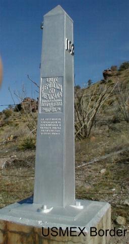
| LOOKING SOUTH AT MEXICO* Where are we at on the AZT? This 22 mile section starts at the Mexico border in the Coronado National Memorial and ends at the south side of Parker Canyon Lake. Route: To get near the southern starting point of the AZT, go to Montezuma�s Pass. It�s located in the Coronado National Memorial, which is about 20 miles south of the city of Sierra Vista. The Pass is located up the mountain, a dirt road drive west of the Memorial Headquarters. You can�t miss the Montezuma Pass TH as there�s a large parking lot, bathrooms, signs, etc. The starting point of the AZT is actually south of Montezuma�s Pass. Yep that�s right, to start the 700+ mile AZT from south to north, you hike 1 � miles south to a 7�-8� silver pointed monument at the U.S./Mexico border. I guess you actually illegally cross a fence into Mexico, take pictures, climb back over the fence and hike back to the Pass. It�s an easy, scenic and informative walk. At this time, because you are at the start of the wonderful AZT, you will really be revved up. Take your time and enjoy the first miles. Back at the Pass, across the road from the Pass�s parking lot, the trail heads north on Crest Trail #103 into the Huachuca Mountains towards Miller Peak (about 9466�). This segment is a good initiation to the AZT with remnants of old mines, scenic views to Mexico, and a rapid elevation change. You�ll do some huffing. Along the way, you�ll pass the junction with Lutz Canyon Trail before arriving at a side trail that goes to Miller Peak. If you�re into peak bagging, this takes a small amount of effort. At the top of Miller Peak, the panoramic views south and west are breathtaking but you may not want to look north at the sprawling city of Sierra Vista. It ain�t exactly pretty. Returning to the Crest trail, it levels out and the hiking is very easy. About � mile past Bathtub Springs, continue on Trail #103 that heads west, and initially quite steep, down the mountain (see Caution below). You can crank out some quick miles thru here or chill out and enjoy the delightful trail thru the forest. There were several possible springtime streams through here and many good camping spots too. After 3+ miles from Bathtub Springs, the AZT leaves Trail #103 south of Pat Scott Peak and heads towards Copper Glance mine. The downhill steepness soon gives way to an easy going, creekside trail #117 in Sunnyside Canyon until it passes out of the Miller Wilderness area. If you are getting antsy, wondering if you are on the AZT as you are walking along the creek, keep an eye out for a large parking/camping area. It is on the right (north) side of the trail. About a 1/4-1/2 mile west of the there, beside the trail/road is a small AZT sign that takes you to Scotia Canyon. From there, the trail #127 heads west and south through Scotia Canyon for about 4 miles, crosses FR #48 and in another mile reaches an AZT sign on the south edge of Parker Canyon Lake. Worthwhile Detours from the AZT: 1) Miller Peak at 9,466 is the highest point in many a mile; 2) Coronado National Memorial Visitor�s Center � lots of interesting stuff in a small space. Places to Camp: 1) Near Bathtub Springs is a good first night camp. It�s about 6 miles from Montezuma�s Pass. But, and I�m only going to say this once, camp several hundred yards away from any water source as the local animals want to drink the water too. Two small herds of deer went down the trail past our campsite in the middle of the night on their way to Bathtub Spring. 2) There are lots of possible campsites near the trail as it heads west down the Huachuca Mts. 3) Parker Canyon Lake: A) There�s an established $10 a night campground on the north side of the Lake (the side opposite the AZT). It has running water, picnic tables and bathrooms. Or B) if you prefer to stay close to the established trail, there�s plenty of flat land as the trail passes south of the lake. Length - 22 miles. How are you feeling? Power Rating � Overall this section is moderate. The trek north from the Montezuma Pass parking lot to below Miller�s Peak isn�t easy. That section is steep with an elevation gain of about 2,800�. You will definitely break a sweat. Generally the trail in this entire 22 mile segment is solid and distinct in most places. But expect snow to cover the trails on the north side of the mountain in the winter and early spring months. Water* � Maybe at Montezuma Pass, ask a ranger at the Memorial Visitor�s Center. And Bathtub Spring usually has water; in the spring there may be several streams near the trail, down the west side of the mountain; and Parker Canyon Lake has water too. Also, when you get to the AZT Trailhead sign at Parker Canyon Lake, you can walk east on the road about a mile to the private residences. There's a few year-round residents who are friendly and might provide some water. And there's the Marina Store on the north side of the lake that has water, Pepsi's and other supplies too. It's closed Wednesday's. The Parker Lake Campgrounds have water too. Bikeable? Well you can get from Montezuma's Pass to Parker Canyon Lake but most of the journey won't be on the AZT because the trail immediatly heads into the Miller Peak Wilderness area. But the suggested 21 mile bike route is an easy one. It starts at the Montezuma Pass parking lot and proceeds west down the mountain, on Forest Road #61. You'll fly for several miles. Then the road becomes less steep. After about 13 miles on FR #61, it comes to an adjoining small road that is signed and heads north to Sunnyside Canyon. Go that way. It's a rougher ride but after 3 miles the road comes to T. There's a sign there that points left to #4759 and Ft Gate #7 (and right to Sunnyside Canyon on #228). Go left on #4759 for about .3 of a mile where there are AZT signs indicating it crosses the road. Turning left onto the AZT leads into a wonderful trail through Scotia Canyon (though it was scorched in 2003 by a forest fire). This fun little ride lasts for about 4 miles where the AZT returns to FR #61. Continue on the AZT route as it crosses FR #61 for another 1.2 miles to a Arizona Trail Head sign on the south side of Parker Lake (and high above the lakeshore). Unfortunately the lake's campground and store are on the north side of the lake, a ride of about 3-4 miles. Dave's rideablity scale: Over 90% rideable tho mostly not on the AZT. Permits � None needed but you can�t camp overnight in the Coronado National Memorial, which includes Montezuma�s Pass. Maps** - 1. �Hiker�s Map of Huachuca Mtns�, $4 from the Coronado National Memorial Visitors Center, 520-366-5515 2. Coronado National Forest Map, Nogales and Sierra Vista Ranger Districts, 520-670-4552 3. The Arizona Trail Association sells maps of most segments - call 602 417 9300. Advice - Visit the Memorial Headquarters Visitor Center. The rangers are friendly and helpful and the Center has lots of trail and area information. Also take time at Montezuma�s Pass to enjoy the views and read the interpretive signs about Coronado�s journey thru this area in 1540. There�s lots of history in this area and the National Parks Service has done a wonderful job of capturing it. Try to contain the natural instinct to get your adventure underway too quickly, i.e. a good place to start practicing �Stop and smell the wildflowers.� Cautions - 1) Don�t get spooked if you run into a Mexican walking north in this area. He or she is probably just heading north to find a job. 2) So you don�t end up back in Sierra Vista, when you get � mile NW of Bathtub Springs be sure to take the turn that heads west, steeply down the mountain. Don�t take the trail #107 that goes to Carr Peak. The directional sign in March 2001 made it appear the Crest Trail and the Carr Peak Trail went the same direction. They don�t. Life on The AZT � I liked looking out over the San Pedro Valley where Coronado�s entourage passed 460 years ago. Maybe in a past life I was with Francisco and the entourage..��..nah, most likely I was eating gruel near a peat bog trying to grow a few potatoes. *Remember just about all water sources are seasonal in Arizona. Check with as many sources as possible before entering an area, including the local National Forest Service. ** In addition to On the Arizona Trail guide book |
 |