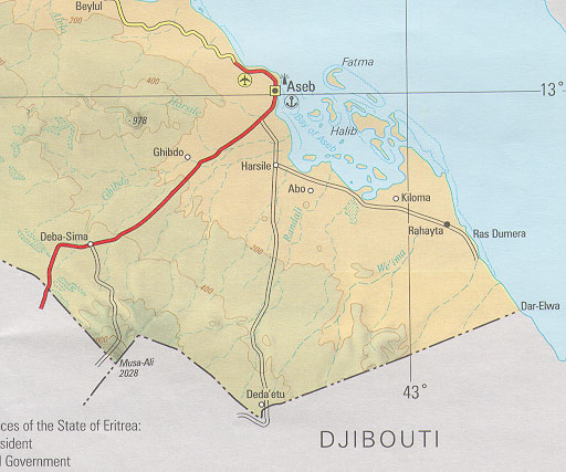
An Illegal Map? - Eritrea's official map of 1995 annexes a portion of northern DjiboutiThe Gundet Newsletter, May 18, 1999The Eritrean government published a new official map in 1995. The graphic below depicts a portion of this map along the Djibouti-Eritrea border. The map shows a strategic section of northern Djibouti from Ras Doumera to Dar Elwa, annexed to Eritrea. The area is strategic because it borders the Bab-el Mandeb strait on the entrance to the Red Sea. The Eritrea-Djibouti border as depicted on the new Eritrean map conflicts with all other common maps in public circulation. In particular, the map violates the orientation of the border as depicted in the authoritative reference �African Boundaries : A Legal and Diplomatic Encyclopedia" by Ian Brownlie. Readers are encouraged to verify this for themselves. For example, Dar Elwa is clearly depicted in Djibouti according to �African Boundaries� while the Eritrean map shows Dar Elwa inside Eritrea. Click here for the official Eritrean map of 1995. Click here for the Djibouti-Eritrea border as shown in �African Boundaries�
The Mussolini-Laval AgreementThe source of Eritrea�s claim is well-known. It is the agreement signed between Mussolini and the French Foreign Minister Pierre Laval in January 1935. As part of this agreement, France ceded a strip of northern Djibouti to Italy, and also ceded a strip of northern Chad (the Aozou) to be included in Italy�s Libyan colony. In return, Italy agreed not to support Germany in case it went to war against France. However, this agreement was never ratified by the French parliament, and in fact Italy reneged on the agreement in 1938. Here is what �African Boundaries� has to say on the matter:
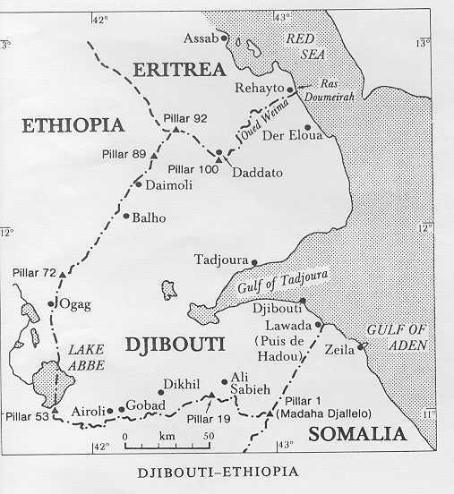
Despite this, Gadhafi tried for many years to annex the Aozou strip to Libya by force. However, Libya�s military invasions were defeated, and Gadhafi was forced to take his case to the International Court of Justice (ICJ). In 1993 the ICJ ruled that the Aozou strip belonged to Chad. Clearly, this was a strong signal that the unratified 1935 Mussolini extortions were not a valid basis for territorial claims. The previous agreement delimiting the Djibouti-Eritrea frontier is the Italian French Protocol of July 10, 1901, which establishes the Oued Weima (a dry streambed) as the boundary between Djibouti and Eritrea from Daddato (Deda�etu) to Ras Doumeirah. The new official Eritrean map places the Oued Weima within Eritrea. Thus it is clear that Eritrea�s new official map is illegal and represents a desire by Eritrea to expand its borders to the Bab-el-Mandeb strait on the flimsy basis of the 1935 Mussolini extortion. Based on Eritrea�s previous aggressive behavior, one can be sure that once the French leave Djibouti, Eritrea will invade and occupy this area. Djibouti will then be forced to negotiate on terms dictated by Eritrea. This is classic militaristic nationalism. Before this happens however, we certainly hope that Eritrea�s military machine will be destroyed and the Eritrean elites will learn the appropriate lesson from their disastrous invasion of Ethiopia. We are waiting to see what the �independent� Eritrean intellectuals have to say on this matter.
Part II: Is Ethiopia�s new map of 1997 Illegal?Eritrean propaganda constantly highlights a new Ethiopian map published in 1997, as being the cause of the current Ethio-Eritrean conflict. This Eritrean propaganda is transparently hypocritical considering Eritrea�s illegal official map of 1995. But it is also false. Ethiopia is well within its rights to map its territory in accordance with the Italo-Ethiopian treaties of 1902-1908. Previous to 1952, all maps depicting Ethiopia were produced unilaterally, by the colonial powers that bordered Ethiopia (France, Italy and Britain). Ethiopia is not bound to these maps. Ethiopia only has a legal obligation to bilateral treaties, and Ethiopia certainly has every right to map its own territory as delimited by those treaties. The following quote may be relevant in this regard:
"Unauthorized aliens" are not going to determine the borders of Ethiopia. With regard to the Eritrea-Ethiopia border, it is obvious that there is a big problem with the Italian maps � they simply don�t match the treaties (for reference see some of the archived articles and maps on this website: http:\\www.geocities.com\~dagmawi). In addition, Italian administration never extended over all the areas claimed by its maps. Thus it is ludicrous to accuse Ethiopia of mapping territory which belongs to Ethiopia according to the Italo-Ethiopian treaties and which has always been under the sovereign jurisdiction of Ethiopia. In fact, it is the Italian maps and any derivatives based on those maps that are illegal.
Conclusions:(1) Eritrea�s official map of 1995 illegally annexes territory belonging to Djibouti. (2) Ethiopia�s map of 1997 is in concordance with the Italo-Ethiopian treaties that provide the basis for delimiting the Eritrean border. |