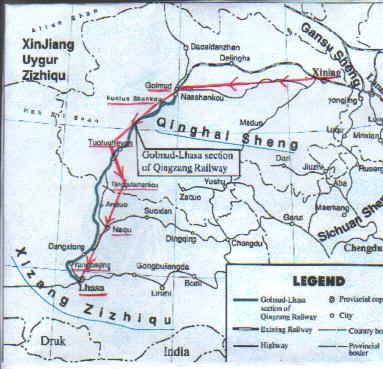
We had 1165km to cover before Lhasa and the journey wouild be broken up over three days. The first lap from Golmud to Tuotuo He the source of the Yangtse River is reputed to be the most difficult and our guide optimistically prepared us for an 8hr drive over 402km. The journey started on a good tarmac highway with desert on both sides and brown mountains in the distance. Cables, wires and electric lines contrast with the gradually opening amphitheatre of rocks, granite and sand. The passing mountains alternated between changing shades of beige, olive and ochre. Although the Qinghai plateau is a desert there is no lack of water because of the many glaciers and spring and underground waters.
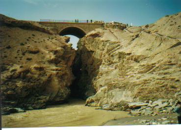
On our steep climb up the Kunlun Pass we stopped by the Kunlun Qiao which is a lookout point for viewing the awesome
rend in the mountains probably the result of a natural fault. At this point we must have been above 4000m but heedless of the height or perhaps we had passed the altitude initiation test, everyone was dashing down the canyon like mountain side without any apparent ill effects. We also rested at the Kunlun Quan which is a natural spring whose waters refreshed Princess Wencheng and her entourage on their epic journey to Lhasa or so the story goes.
In front of the Xue Shan Cafe, where we had our lunch, the white tongue of the Meikuang Glacier protruded down the Kunlun
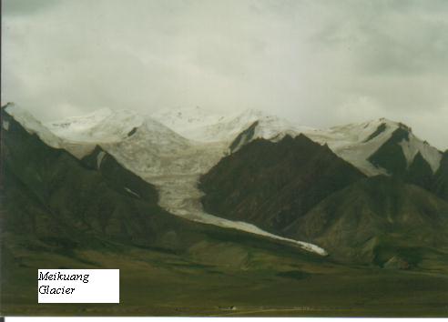
Mountain slopes. Shortly after we were elated when light snow dusted our windscreens in chilly salutation. The weather is unpredictable and an azure sky greeted us on the top of the mountain pass. The scenery like the rarefied air took our breath away. Stretched before us were endless vistas of snow fields and moorland pierced by Yuzhu Peak (6177m) of the Kunlun Mountains. A recent earthquake had broken in two, the landmark plaque flanked by a snow lion and an eagle decked with white scarves.
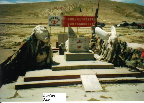
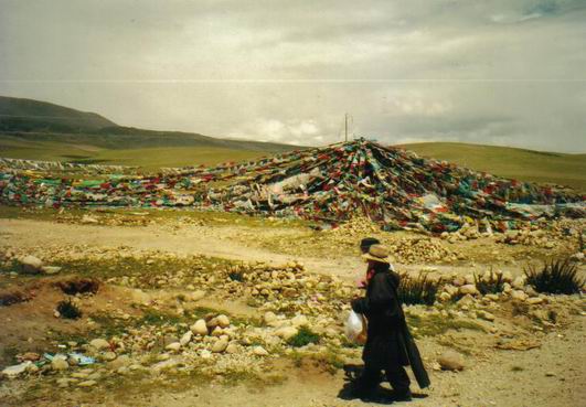
The Chinese marks high passes with pillars, statues and plaques. The Tibetan way is more artistic and spiritual. They decorate the passes with gossamer flags which hang in long strands from poles or tied together to form a pyramid like structure. These prayers flags have chants inscribed on them and wing their way heavenwards. Small cairns built with stones and rocks and some times laced with prayer flags and wild flowers are another Tibetan expression of reverence. We cherished a few silent moments to celebrate the peace that such high places inevitably brings.
So far we had been having it easy on our most difficult day but leaving the pass our trip literally started going downhill. It has been said of this highway that if the mountains don�t kill you the traffic jams and road blocks would. The Qinghai Tibetan Highway at an average elevation of 4000m is under constant stress all year round from adverse weather conditions and wild fluctuations in temperature causing the road surface to crack up and break open. Whole stretches of the Highway maybe arbitrarily closed without prior warning for repair and resurfacing. Travelers along this way really have to chance it.

Just looking at the line of vehicles lined up bumper to bumper was enough to give us mountain sickness. All the vehicles including ours had their ignition off and from the stoic atmosphere all round it looked like everyone was prepared to camp overnight on the mountain. The guides tried every trick in the book to get us out of the jam. An eternity afterwards a policeman comes aboard to inspect us. It transpired that our guide had �bluffed" him that some of his passengers had taken ill and to give us special concession. Our wan faces must have convinced him because miraculously he agreed to let us move and was quite solicitous about our welfare! At the next road block we were not as lucky. We were not accorded VIP treatment and had to wait in line until the authorities gave the green light which was many moons later!
The road blocks and jams had delayed us by many hours and we had hundreds more kilometers to cover before Tuotuo He. The road had turned very rough and it felt like we were on the dirt track but I couldn�t see as it was pitch dark outside and inside. The coach raced along at breakneck pace in a race against time. I did not know whether to be glad or alarmed by the darkness. The altitude was getting to our heads and hunger was gnawing at us. Instead of enjoying Qinghai�s endless plains, it felt more like enduring endless pain on an endless journey! In this manner we must have climbed to the Feng Huo Shan Pass at 5100m in the dark! And we were to pass the source of Tuotuo He at 4530m in this manner too. We were too dumbstruck and shell shocked to complain that we had missed all the sights.
At 11.30 pm we finally pulled up at Tuotuo village, 4650m for dinner and at 12.30pm, after 18hrs on the road we reached our overnight hotel. The �hotel' which everyone afterwards referred to as the �Hei Dian' or Black Inn did not have electricity. The entrance was lit up with a gas lamp but the interior was plunged in ghostly shadows. Someone was passing candles around and in the confusion we were shunted into shack like rooms. I tottered to the common loo which by the light of a torch turned out to be a trench!
Barely had our heads touched the pillow when it was morning call at 5 am and we were on the road again. This stage would take us from Tuotuo He to Naqu over 433km in blank hours, no one dared hazard a guess. We were beginning to feel suicidal and fatalistic as the previous days pattern was replayed. The worst ordeal was when we were held up for 3 hours. Some of us then decided to convert our seats into daybeds by pulling out the centre aisle seat and settled down for a well earned snooze. Those of us who did not gain this privilege commented that the coach was taking on the appearance of an ambulance.
After all the jams and blocks and diversions, we were finally riding on the highest road in the world. With glaciers flanking both sides of the road we ascended the Tanggula Pass at 5231m which is the highest point in the Qinghai Tibet Highway. For a lowlander like me, 5231m was indeed a high point in my life. And now I felt that the hardship of traveling this road was well worth it. I couldn�t get over the wonder that I was higher than the peak of Europe�s Mt. Blanc or the Annurpurna base camp. �What is a mountain peak elsewhere in the world is but a highway in Tibet!" - is an appropriate tribute to the ingenuity of the Chinese road builders.

At this altitude harsh natural conditions are the order of the day. The average annual temperature is -8C with the lowest temperature reaching -40C. The oxygen content here accounts for only 50 percent of the volume at sea level hence the area is regarded as a �life-threatening zone" Even in August we donned down jackets and mittens when we stepped out into the thin air and bitter cold to experience the barren wilderness.

For obvious reasons, the pass is not a place to tarry and we descended swiftly following the highway until we leave Qinghai province behind and arrive at Tibet�s most northerly town Naqu. Naqu is the administrative headquarters of Northern Tibet and here in a symbolic gesture to mark our stepping on Tibetan soil, we were greeted with white scarves.
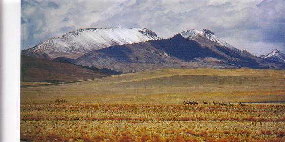
On our third and last day�s ride into Lhasa, the road improved and we covered 330km over 5hours. From Naqu onwards the bleak and desolate Qinghai plateau is replaced with pastoral scenes of sunny valleys and running streams. We start to catch glimpses of colour - valley floors golden with rapeseed wheat and maize, hill slopes dotted with clumps of mauve, pink and blue wild flowers and of course black yaks, white goats and wild ponies. Footbridges over streams are festooned with prayer flags, medieval Tibetan farmhouses with flat roofs and square cut windows are hung with bright strips of cloth, while electric wires compete with prayer flags which fly like ship�s mast from every Tibetan homestead. It gets to look more and more like God�s own country and it is not for nothing that Tibet is known as the Holy Land.
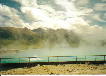
Stopping by the Yangbajing Hot Springs we are an easy 91km away from Lhasa.
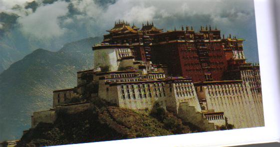
As we approached the Holy City we felt charged by energy from the sun. Lhasa is also known as the City of Sun with 3000 hours of sunlight annually and the intensity of the sun is like nowhere else on earth. Bathed in this radiance we follow the tree lined road until the golden roofs of the Potala Palace told us that we had arrived.
Picture References:
Faces of Tibet, Where beauty roams and Potala Palace taken from the book "Touring Ngari in Tibet"
Other pictures by Heng.
Internet references: Route Map taken from: http://home.c2i.net
Our trip to Tibet took place in August 2002.
Go Back to Previous Page