|
|
||||||||||
|
|
||||||||||
Aerial Views |
||||||||||
|
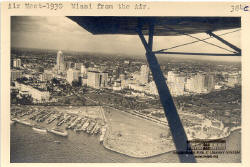
Air Meet, 1930 Miami from the Air |
This is an aerial view of downtown Miami in January, 1930. The view is from over the mouth of the Miami River looking northwest. The old Royal Palm Hotel can be seen at the left edge of the photograph. Bayfront Park is in the foreground with the Band Shell partially covered by the wing support. The County Courthouse, then the tallest building in Miami, is visible in the distance. |
|||||||||
|
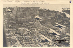
This January, 1930 aerial view of the downtown area is from the northwest. The County Courthouse on Flagler Street is partially covered by an Army bomber in the center of the frame. Bayfront Park and the mouth of the Miami River are visible in the distance. The military aircraft shown in the photograph were visiting Miami to participate in the annual All American Air Meet held at Municipal Airport. |
Air Meet, 1930 Bombers over Miami. |
|||||||||
|
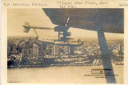
Pan American Airways: Over Miami from Air |
A Pan American Sikorsky S-40 Clipper Ship flying over downtown Miami. Bayfront Park and the hotels along Biscayne Boulevard can be seen in the foreground. The Freedom Tower, then the home of the Miami News newspaper, is visible at the right edge of the frame. |
|||||||||
|
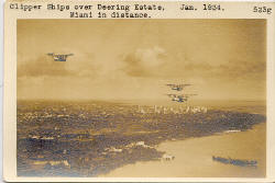
Three Pan American Sikorsky S-40 Clipper Ships flying over Biscayne Bay. This January, 1934 aerial view is from the south. Coconut Grove and the Deering Estate are seen in the foreground. Downtown Miami is in the center of the frame and the islands of Miami Beach are barely visible in the distance. Pan American's Seaplane Terminal was located at Dinner Key in Coconut Gove. Much of the area between Downtown Miami and Coconut Grove was still undeveloped at this time. |
Miami Skyline. Three Clippers over Vizcaya. 1934. |
|||||||||
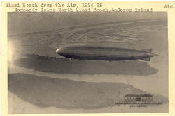
"Los Angeles" over Normandy Isle & N.M.B. 1925 |
The U.S. Navy Dirigible "Los Angeles" seen over northern Miami Beach in the mid-1920s. The two islands of Normandy Isles are undeveloped in the foreground. Most of Miami Beach is visible in the distance. South Beach was the only commercially developed area of Miami Beach at this time. | |||||||||
| This 1935 photograph shows the Goodyear blimp "Defender" flying over Bayfront Park. The Everglades and Columbus Hotels are seen at the edges of the photograph. The County Causeway crossing Biscayne Bay to Miami Beach can be seen in the distance. After World War II, the causeway was renamed McArthur Causeway to honor General Douglas McArthur. |
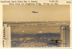
Bayfront Park, Biscayne Bay & Beach from Roof of Congress Bldg. Blimp in Sky. 2-25-35 |
|||||||||