|
|
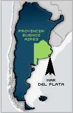 |
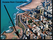
Mar
del Plata is
located in Buenos Aires Province on the oriental foothills of the Northern
Hills, by the Atlantic Ocean, To get to this region you can take Nº
2 National Route and Nº 11 Provincial Route. There is an International
Airport called Brigadier Bartolomé de la Colina a few kilometers
away from the city that operates 10 daily flights from Buenos Aires. Mar
del Plata has a temperate climate dominated by masses of humid, hot, sea
subtropical air from the semi permanent anticyclone of the Atlantic. The
average temperature is higher than 22º C in the hottest month, the
annual average temperature is 14º C and the maximum registered temperature
is 35º C. This city is the perfect combination for those who search
for tranquility and rest as well as for the possibility of finding everlasting
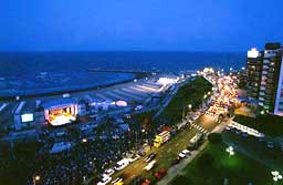
noise and entertainment Mar del Plata is a city with many challenging
opportunities. |
|
|
Attractions:
Cliffs, ravines, dunes and long beaches help you to enjoy the sun of summer
through golf, bike crossings, horse rides or four track excursions. In
the air, you can enjoy paragliding, tandem or first flights and also water
sports such as windsurfing, jet skiing, diving sailing and swimming. At
night, pubs, discos, Theatres casino and bingos are ready to receive the
most demanding tourists |
|